


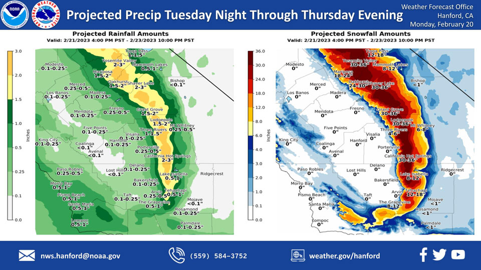
Projected Precipitation for Mariposa and Oakhurst 1.50" to 2.00"
Projected Precipitation for Yosemite Valley: 2.00" to 3.00"
February 20, 2023 - The National Weather Service Hanford Office reports the first in a series of cold storm systems this week will impact Central California Tuesday night through Thursday evening, resulting in low elevation snow and a chance of rain in the San Joaquin Valley.
Snow levels will start at around 5,000 feet Tuesday night, before dropping to about 1,000 feet Wednesday.
The majority of this precipitation will fall Wednesday afternoon through Thursday evening.
Area Forecast Discussion
National Weather Service Hanford CA
204 AM PST Mon Feb 20 2023
.SYNOPSIS...
Dry conditions through Tuesday morning. Wind increases Tuesday
afternoon and remain high through Wednesday morning. Winter Storm
Watch is in effect from late Tuesday night through Saturday
morning.
&&
.DISCUSSION...
A ridge is currently sitting off the coast with a
shortwave trough to the west of Baja California. This ridge has
helped keep us above average the past few days. However, this set up
will dissipate starting Tuesday as a strong trough slides through
the area. The winds will pick up ahead of the precipitation due a
very tight pressure gradient from the trough. This increase in winds
have led to the issuance of a Wind Advisory for the San Joaquin
Valley and West Side Hills as gusts will get up to 40 mph in the
Valley and 50 mph in the West Side Hills Tuesday night through
Wednesday morning. In Kern County, the Mojave Desert slopes and Kern
County portion of the desert will see wind gusts up to 65 mph which
warranted an increase from a High Wind Watch to a High Wind
Warning.
GEFS and European model ensembles are in good agreement about the
positioning and strength of the trough that moves in Tuesday. Both
model ensembles also agree a second shortwave trough later on
Thursday in Friday will move through and strengthen. However, both
the ensembles start to differentiate with regards to the positioning
of the second trough on Thursday through the weekend.
Tejon and Tehachapi Passes will be areas of heavy impact from this 1-
2 punch as snow levels are expected to drop to 1,000 to 1,500 feet
during the storm. Current snow forecasts are showing up to a foot of
snow between 1,000 and 4,000 feet and between 1 to 2 feet of snow
above 4,000 feet for the passes. This amount of snow will result in
the passes needing to be closed for a period of time which will
impact traffic getting to and from Los Angeles.
The Sierra Nevada and the foothill areas including Mariposa and
Oakhurst are also under a Winter Storm Watch from Tuesday afternoon
until Saturday morning. The foothill areas between 1,000 feet and
3,000 feet including Mariposa and Oakhurst could see 1 to 2 feet of
snow from the two storms. Between 3,000 and 5,000 feet the expected
accumulation increases to 2 to 3 feet and 3 to 4 feet of snow can be
expected above 5,000 feet. Travel will be nearly impossible for many
of the foothill communities due to the amount of snow.
Latest probabilistic forecasts have less than 33 percent chance of a
tenth of an inch of rain accumulating on Wednesday for the San
Joaquin Valley. The probabilities increase to being between 35 and
60 percent chance of a tenth of an inch of rain for both Thursday
and Friday.
&&
.AVIATION...
VFR Conditions will prevail for the next 24 hours for Central
California with some spots of MVFR possible until 18Z today.
&&
.AIR QUALITY ISSUES...
ISSUED: 02/19/2023 13:54
EXPIRES: 02/20/2023 23:59
On Monday February 20 2023, Fireplace/Wood Stove Burning Status
is: No Burning Unless Registered in Fresno, Kern, Kings, Madera,
Merced, and Tulare Counties. Burning Discouraged in Kern (Greater
Frazier Park Area) and Sequoia National Park and Forest.
&&
.CERTAINTY...
The level of certainty for days 1 and 2 is high.
The level of certainty for days 3 through 7 is medium.
Certainty levels include low...medium...and high. Please visit
www.weather.gov/hnx/certainty.html for additional information
and/or to provide feedback.
&&
.HNX WATCHES/WARNINGS/ADVISORIES...
High Wind Warning from 10 AM Tuesday to 10 AM PST Wednesday for
CAZ337>339.
Wind Advisory from 1 PM Tuesday to 7 AM PST Wednesday for
CAZ300>316.
Winter Storm Watch from Tuesday afternoon through late Friday
night for CAZ318-320-322>331.
Winter Storm Watch from Tuesday evening through late Friday
night for CAZ332>336.
Source: NWS
