


Includes Mariposa, Oakhurst and Yosemite National Park
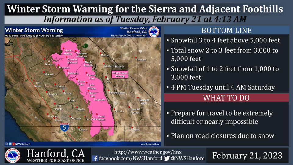
February 21, 2023 - The National Weather Service Hanford Office reports a Winter Storm Warning is in effect for the Sierra Nevada and adjacent foothills from 4:00 P.M. Tuesday afternoon until 4:00 A.M. early Saturday morning.
A Winter Storm Warning means significant snow accumulations will make travel very difficult to impossible.
The majority of this snow will fall Wednesday afternoon through Thursday night.
Winds may gust as high as 70 mph on exposed ridgetops and near the crest.
Travel could be extremely difficult or impossible. If you plan to travel, consider alternate strategies. If you must travel, remember to carry tire chains, plenty of food, a good deal of water, warm clothing, and a flashlight in your vehicle.
Winter Storm Warning
URGENT - WINTER WEATHER MESSAGE
National Weather Service Hanford CA
137 AM PST Tue Feb 21 2023


Mariposa-Madera Lower Sierra-Fresno-Tulare Lower Sierra-
South End of the Lower Sierra-Yosemite NP outside of the valley-
Yosemite Valley-San Joaquin River Canyon-Upper San Joaquin River-
Kaiser to Rodgers Ridge-Kings Canyon NP-Grant Grove Area-
Sequoia NP-South End of the Upper Sierra-
Including the cities of Bass Lake, Coarsegold, Fish Camp,
Oakhurst, North Fork, Auberry, Camp Nelson, Tuolumne Meadows,
Wawona, Yosemite Valley, Devils Postpile, Florence Lake,
Lake Thomas Edison, Lake Wishon, Huntington Lake, Shaver Lake,
Cedar Grove, Grant Grove, Hume Lake, Giant Forest, Lodgepole,
and Johnsondale
137 AM PST Tue Feb 21 2023

...WINTER STORM WARNING REMAINS IN EFFECT FROM 4 PM THIS
AFTERNOON TO 4 AM PST SATURDAY...

* WHAT...Heavy snow possible. 1 to 2 feet of snow accumulation
  from 1,000 to 3,000 feet, 2 to 3 feet of snow accumulation
  from 3,000 to 5,000 feet, and 3 to 4 feet of snow accumulation
  above 5,000 feet. Winds could gust as high as 70 mph.

* WHERE...The Sierra Nevada and Foothills.

* WHEN...From 4 PM Tuesday to 4 AM PST Saturday. Snowfall will
  occur with two main systems. There may be brief breaks between
  systems.

* IMPACTS...Travel could be very difficult to impossible. The
  hazardous conditions could impact the morning or evening
  commute. Very strong winds could cause extensive tree damage.
  The cold wind chills as low as 30 below zero could cause
  frostbite on exposed skin in as little as 30 minutes.

PRECAUTIONARY/PREPAREDNESS ACTIONS...

If you must travel, keep an extra flashlight, food, and water in
your vehicle in case of an emergency.

The latest road conditions for the state you are calling from can
be obtained by calling 5 1 1.
Source: NWS
