


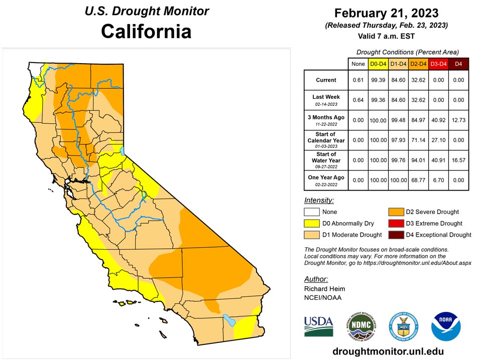
California and National Drought Summary for February 21, 2023
Summary
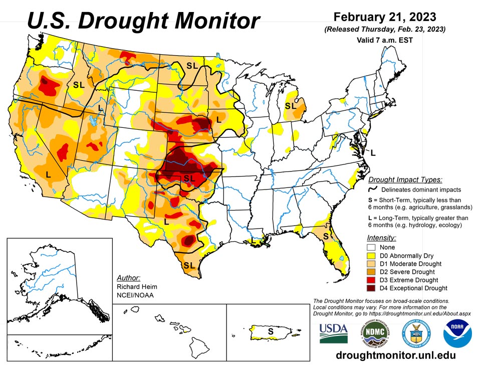
February 23, 2023 - An upper-level ridge over the northeastern North Pacific Ocean deflected Pacific storm systems away from the West Coast of the contiguous U.S. (CONUS) during this U.S. Drought Monitor (USDM) week (February 15-21). This resulted in a generally drier-than-normal week over much of the West. An upper-level trough developed over the western CONUS downstream from the ridge, and the trough was responsible for a cooler-than-normal week over the West. Strong high pressure over the Gulf of Mexico extended into a ridge across the East Coast. A southerly flow between the trough and eastern ridge spread warm, moist air from the Gulf of Mexico across the eastern CONUS and directed weather systems northeastward from the southern Plains to Great Lakes. Two weather systems early in the week generated above-normal precipitation across parts of the central to eastern CONUS. As the week ended, weather systems moved across the northern tier states, bringing areas of snow. The week was wetter than normal across parts of the northern Rockies, from the Four Corners states to western Great Lakes, and from the central Gulf Coast states to Ohio Valley and Mid-Atlantic states. It was a drier-than-normal week across much of the West, southern Plains, coastal Southeast, and southern Great Lakes to New England, and parts of the northern to central Plains. Drought or abnormal dryness expanded where it continued dry in parts of the Pacific Northwest, southern Plains, and Florida. Drought or abnormal dryness contracted or reduced in intensity where it was wet over parts of the Four Corners area, southern and central Plains to Upper Mississippi Valley, and the Big Island in Hawaii.
Northeast
An inch or more of precipitation fell across southern parts of the Northeast region, with West Virginia receiving over 2 inches. Half an inch or more extended northward to southern Pennsylvania and southern New England, while half an inch fell over northern Maine. The rest of the Northeast had less than half an inch. Other than abnormal dryness contracting in West Virginia, there was no change in status for the Northeast, with a small area of moderate drought remaining over eastern Maryland and spots of abnormal dryness scattered across other states.
Southeast
Weekly precipitation totals across the Southeast region ranged from over 2 inches in the north and west to no precipitation across much of the Florida peninsula. Abnormal dryness expanded to all of the west coast of the Florida peninsula. Otherwise, there was no change in status for the Southeast, with some moderate drought remaining in Florida and southeast Georgia and a few spots of abnormal dryness in other states.
South
Two inches or more of precipitation fell across eastern portions of the South region, specifically parts of Mississippi and much of Tennessee. Half an inch or more occurred from there to eastern Oklahoma and northeast Texas. For the rest of Oklahoma and Texas, the week continued a dry pattern. Abnormal dryness and moderate to extreme drought contracted in eastern Oklahoma, due to wet conditions this week and previous weeks and improved soil moisture and streamflow conditions, and abnormal dryness contracted in northeast Texas. But extreme to exceptional drought expanded in western Oklahoma and the Texas panhandle, while abnormal dryness and moderate to severe drought expanded in parts of southern Texas along the coast and along the Rio Grande River where streamflow and soil moisture conditions deteriorated and precipitation deficits continued to grow. According to media reports, 80-mph winds created a dust storm in the Oklahoma panhandle that caused a multiple car pileup, killing a driver.
Midwest
Multiple storm tracks gave the Midwest region wet conditions along the Ohio River in the south and across the Upper Mississippi Valley and western Great Lakes in the north and west. Half an inch to an inch or more of precipitation fell in these wet areas, while a dry band of less than a quarter of an inch stretched from central Illinoi to northern Ohio and southeast Michigan. Totals over 3 inches resulted in flood warnings in Kentucky. Soils in the Upper Mississippi Valley were dry in the fall, and these dry conditions were locked in place as the soils froze with the onset of winter. The recent precipitation reduced moderate to extreme drought in Minnesota, Wisconsin, and Iowa, but the extent of abnormal dryness was kept intact to reflect the dry and frozen soils that haven’t benefited yet from the rain and snow. Abnormal dryness contracted in southern Indiana, and abnormal dryness and moderate to severe drought contracted in northwest Missouri. Moderate to severe drought continued in Lower Michigan.
High Plains
A storm system tracked across southern parts of the High Plains region early in the week, with another late in the week tracking across northern Wyoming. Weekly precipitation totals were half an inch to over an inch in parts of Wyoming, Colorado, northern and eastern Kansas, southern and eastern Nebraska, and southeast South Dakota. The rest of the region received little to no precipitation. Moderate to exceptional drought was trimmed in a few areas of northwestern and eastern Kansas, and adjacent parts of Nebraska, while abnormal dryness and severe drought were trimmed in southern Colorado. No change was made to the drought areas in the rest of the region.
West
Half an inch of precipitation fell over a few areas in the Four Corners states and in western Oregon, while 2 inches or more of precipitation occurred over parts of the Washington Cascades and northern Rockies. But for the most part, little to no precipitation fell across large parts of the West region. Abnormal dryness and moderate to severe drought were trimmed in northwest New Mexico where this week was wet and moist conditions were evident in soil moisture, snowpack, and Standardized Precipitation Index (SPI) indicators. But low streamflow, snowpack, soil moisture, and SPI values prompted expansion of abnormal dryness and moderate drought along coastal Oregon and southwest Washington, as well as in the Idaho panhandle. While many reservoirs in California have recovered from the recent atmospheric river events that have struck that state, reservoirs in Oregon continue at drastically low levels and some reservoirs in Utah remain at low levels. As of February 21, 2023, the water level in Lake Powell was 3521.53 feet above sea level, which is the lowest level recorded since the lake was filled in the 1960s. As noted by the media, Lake Powell is a man-made reservoir that sits along the Colorado River on the Arizona-Utah border. It generates electricity for about 4.5 million people and is a key part of the Colorado River Basin system, which supplies water to more than 40 million people. Further north, an extension agent in Blaine County, Montana, reported the drought is causing reduced water for irrigation, later emergence of spring grasses, and grazing must be supplemented and water hauled for livestock
Caribbean
Rain fell across the northeastern half of Puerto Rico, with a few locations receiving an inch or more for the week. But most of the island was drier than normal. There were local observations of vegetation drying along the southeastern coast, but other indicators (streamflow, reservoirs, groundwater) were optimal, so there was no change in status for Puerto Rico.
Most of the U.S. Virgin Islands have remained drier-than-normal this week. The satellite data (i.e., National Weather Service’s seven-day quantitative precipitation estimates) and station observations show that the rainfall amount received over most parts of the islands was less than 0.5 inches. The one- and three-month Standardized Precipitation Index (SPI) maps shown that conditions are still dry at St. Thomas and St. Croix. However, St. John was in relatively near-normal condition. Vegetation Health Index there has been no stress showed on vegetation during this week.
Specifically, St. John (Rafe Boulon/Windswept Beach) reported 0.31 inch of rain this week. The depth to water level at Susannaberg DPW 3 well (St. John, USVI) on February 22 was 11.53 ft below land surface. Even though there has been a decreasing trend in water since November 2022, the depth to water level at Susannaberg DPW 3 well is relatively lower than it was September to November 2022, resulting in a near-normal condition, so St. John remains at the status quo of drought-free conditions.
St. Croix (Henry Rohlsen AP) reported 0.16 inch of rain this week. The depth to water level at Adventure 28 Well (St. Croix, USVI) on February 22 was 27.00 ft below land surface. The analysis showed a significant decrease in water level (about 2 ft) since November 25, when it was 25.04 ft below land surface. This week’s 1-month and 3-month SPI also confirms dry conditions persist on the island, so St. Croix remained in short-term moderate drought (D1-S) this week.
St. Thomas (Cyril E. King Airport) received 0.49 inch of rain this week. There was also an increase in depth to water level at St. Thomas. The depth to water level at Grade School 3 well (St. Thomas, USVI) on February 22 was 7.62 ft below land surface. Although conditions were slightly approved on the island, St. Thomas remained in short-term moderate drought (D1-S) this week due to previous deficits.
Pacific
Drier- and colder-than-normal weather dominated Alaska, except for southern coastal locations. But with near to above-normal snowpack, no change was made to the depiction in Alaska, which remained free of drought and abnormal dryness.
In Hawaii, a Kona Low dropped one to two feet of rain over the Big Island, and 3 to 6 inches of rain were recorded over Oahu. Maui was the driest island with less than 3 inches recorded. But all of the main islands were wetter than normal this week, with this week’s rainfall giving the Big Island above-normal statistics for the last 1 to 6 months. Abnormal dryness (D0) was eliminated from the Big Island, leaving a small area of D0 remaining over Maui.
American Samoa remained free of drought this week. With one day missing, weekly rainfall amounts of 3.01 inches at Siufaga Ridge, 2.91 inches at Toa Ridge and 6.46 inches at Pago Pago.
Drought is not currently a concern in Palau, as rainfall totaled 1.46 inches at Koror COOP and 1.80 inches at Palau IAP (Airai).
Wetter-than-normal conditions returned to the Mariana Islands this week. Rainfall amounts on Rota and Guam were 3.65 and 3.15 inches, respectively. On Saipan, rainfall amounts observed at Saipan (IAP, manual gauge), Saipan (ASOS) and Saipan (NPS) were 1.90, 1.74 and 1.37 inches, respectively. The Mariana Islands remained drought free this week.
Wet weather continued at Yap, Korae and Ulithi this week, where rain totaled 2.89, 2.44 and 2.18 inches, respectively. Pohnpei reported 1.43 inches of rain this week while Chuuk, Nukuoro and Woleai each received below-normal rainfall amounts of 0.48, 0.89 and 0.99 inches, respectively. These locations remained free of abnormal dryness, though, due to wetter preceding conditions. Dry conditions continued on Kapingamarangi receiving 0.46 inch of precipitation this week as the island remains in short-term abnormally dry condition. On Lukunoch, conditions continued to deteriorate this week resulting in three consecutive weeks of below normal precipitation (i.e. 1.75”, 0.45” and 0.29”). Lukunoch was moved to abnormally dry conditions this week. Similarly, Pingelap has deteriorated to abnormal dry conditions this week due to below-normal precipitation over the past three weeks (i.e. 0.04”, 1.06” and 0.77”). No depiction was made for Fananu due to missing data (six days missing).
Heavy rains were observed on Mili and Jaluit this week with 3.30 inches and 2.57 inches, respectively, allowing these locations to remain free of drought. Majuro reported 1.18 inches of rain this week and remained free of drought. Ailinglaplap received no precipitation this week but remained drought free due to above-normal precipitation from previous weeks. Dry conditions continued on Wotje receiving no precipitation this week as the island remains in short-term abnormally dry condition. On Kwajalein, dry conditions continued the past five weeks (i.e., 0.43, 0.23, 0.04, 0.18 and 0.46 inches of rain, consecutively). Thus, Kwajalein deteriorated to moderate drought conditions. No depiction was made for Utirik due to missing data.
Looking Ahead
A strong Pacific weather system moved across the West on February 22, with a low pressure and frontal system spreading rain and snow from the Plains to Mississippi Valley and across northern states. A series of weather systems will follow during February 23-28, spreading an inch or more of precipitation from Oklahoma to the Great Lakes, from the Tennessee to Ohio Valleys, and across much of the Northeast, as well as along the West Coast and into the interior West. Some precipitation totals will exceed 2 inches in the Upper Mississippi Valley and western Great Lakes, and exceed 4 inches along coastal Washington and California and into the Sierra Nevada range. The Gulf of Mexico Coast, western parts of the Great Plains, and parts of the Mid-Atlantic Coast will see little to no precipitation. High pressure over the Gulf of Mexico will keep temperatures warmer than normal from the southern Plains to Ohio Valley and Gulf Coast to Mid-Atlantic Coast, while temperatures will be cooler than normal across the Far West to northern Plains. For February 28-March 8, the outlook favors colder-than-normal weather across the West and Alaska, with warmer-than-normal weather from the southern Plains to Atlantic Coast and Great Lakes. Above-normal precipitation is likely across Alaska, the western CONUS, and much of the CONUS east of the Rockies except along the Gulf Coast where below-normal precipitation is favored.
Author(s):
Richard Heim, NOAA/NCEI
Rocky Bilotta, NOAA/NCEI
Dryness Categories
D0 Abnormally Dry—used for areas showing dryness but not yet in drought, or for areas recovering from drought.
Drought Intensity Categories
D1 Moderate Drought
D2 Severe Drought
D3 Extreme Drought
D4 Exceptional Drought
Drought or Dryness Types
S Short-term, typically less than 6 months (agriculture, grasslands)
L Long-term, typically more than 6 months (hydrology, ecology)
SL Area contains both short- and long-term impacts
Source: National Drought Mitigation Center
