


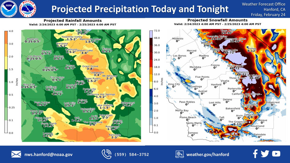
Projected Rainfall for Mariposa and Oakhurst 1.50" to 2.00"
Projected Snowfall for Mariposa: 3-4 Inches
Projected Snowfall for Oakhurst: 2-3 Inches
Projected Rainfall for Yosemite Valley: 1.50" to 2.00"
Projected Snowfall for Yosemite Valley: 24-30 Inches
February 24, 2023 - The National Weather Service Hanford Office reports a strong storm system will impact Central California today and tonight.
In the Sierra Nevada foothills, snow levels will rise to about 3,000 feet this morning.
In Kern County, snow levels will rise to about 5,000 feet this morning.
The majority of this precipitation will fall today.
Area Forecast Discussion
National Weather Service Hanford CA
311 AM PST Fri Feb 24 2023
.SYNOPSIS...
Series of potent winter storms continue to bring widespread
impacts across the district. Heavy snow in the mountains and
snow in the foothills will likely cripple travel through Saturday.
A window for moderate rainfall may lead to nuisance flooding in
the southern portion of the San Joaquin Valley later this morning
through Saturday morning. A break in activity is forecast Sunday,
before another system impacts the region Monday through Wednesday.
&&
.DISCUSSION...
Precipitation is increasing across central California this morning
as the next in a series of winter storms begins to impact the area.
A cold air mass is already in place with snow levels currently near
2000 feet. This has resulted in the closure of Interstate 5 over
the Grapevine Pass within the last hour and could close Highway 58
over Tehachapi Pass as well. Precipitation increases in coverage
and intensity later this morning and continues throughout the day.
Moderate to heavy snow is expected along with strong wind gusts,
resulting in major to extreme impacts across the high Sierra and
the Tehachapi-Grapevine-Frazier Mountain areas in Kern County. A
Blizzard Warning remains in effect for these areas until 8 PM this
evening. A Winter Storm Warning will remain in effect until 4 PM
Saturday for these areas as well as the remainder of the Sierra
Nevada and Kern County Mountains. Southerly flow today will lead
to snow levels rising to around 4000 feet later this morning and
around 5000 feet this afternoon. Snow levels will fall once again
this evening to around 3000 feet then change little on Saturday.
Total snow accumulations could exceed 5 feet over the high Sierra.
Light snow is expected across the Sierra Foothills where a Winter
Weather Advisory is in effect until 4 PM Saturday. Most areas will
receive less than an inch of snow but any snowfall in these areas
can create hazardous conditions.
As precipitation increases later this morning, there is potential
for moderate to locally heavy rainfall. The WPC Excessive Rainfall
Outlook continues to highlight portions of southern California,
with a marginal (5-15%) risk extending over Kern County. Therefore,
a Flood Watch remains in effect for the southern San Joaquin Valley
from 10 AM this morning through Saturday morning. Gusty southerly
winds will continue across the San Joaquin Valley today where a
Wind Advisory is in effect until 4 PM this afternoon. Very strong
southerly gusts will occur over the Kern County mountains today
which will cause reduced visibility in snow and possible whiteout
conditions at times. Thus, the Blizzard Warning is in effect until
8 PM this evening.
The upper low shifts inland over southern California on Saturday
night with short wave ridging building in behind it. Sunday will
likely be dry but model ensembles agree with keeping the pattern
active across California with a couple more systems progged from
Monday through Wednesday.
&&
.AVIATION...
Widespread mountain obscuring IFR conditions in rain/snow. Wind
gusts in excess of 50 knots across the mountains. Areas MVFR and
local IFR conditions in showers across the San Joaquin Valley.
Otherwise VFR conditions are expected to prevail.
&&
.AIR QUALITY ISSUES...
On Friday February 24 2023, Fireplace/Wood Stove Burning Status
is: Burning Discouraged in Fresno, Kern, Kings, Madera, Merced,
and Tulare Counties, and Kern (Greater Frazier Park Area) and
Sequoia National Park and Forest.
&&
.CERTAINTY...
The level of certainty for days 1 and 2 is medium.
The level of certainty for days 3 through 7 is medium.
Certainty levels include low...medium...and high. Please visit
www.weather.gov/hnx/certainty.html for additional information
and/or to provide feedback.
&&
.HNX WATCHES/WARNINGS/ADVISORIES...
Wind Advisory until 4 PM PST this afternoon for CAZ300>308-317.
Wind Advisory until 4 PM PST this afternoon for CAZ309>316-319-
321.
Flood Watch from 10 AM PST this morning through Saturday morning
for CAZ309-310-314>316.
Winter Weather Advisory until 4 PM PST Saturday for CAZ317-319-
321.
Winter Storm Warning until 4 PM PST Saturday for CAZ318-320-
322>333.
Blizzard Warning until 4 PM PST Saturday for CAZ323-326>331.
Blizzard Warning until 8 PM PST this evening for CAZ334>336.
Winter Storm Warning from 8 PM this evening to 4 PM PST Saturday
for CAZ334>336.
Source: NWS
