


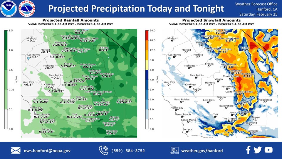
Projected Rainfall for Mariposa and Oakhurst 0.25" to 0.50"
Projected Snowfall for Mariposa: Less than 1 inch
Projected Snowfall for Oakhurst: Less than 1 inch
Projected Rainfall for Yosemite Valley: 0.25" to 0.50"
Projected Snowfall for Yosemite Valley: 3 to 4 Inches
February 25, 2023 - The National Weather Service Hanford Office reports a storm system will remain near Central California today, before exiting the area tonight.
This storm system will be responsible for low elevation snow and rain in the San Joaquin Valley.
Snow levels will be around 2,000 feet. Most precipitation will fall this morning.
Area Forecast Discussion
National Weather Service Hanford CA
351 AM PST Sat Feb 25 2023
.SYNOPSIS...
Precipitation will continue today, bringing more heavy snow for
the Sierra and Kern County mountains, snow for the foothills and
more rainfall to the San Joaquin Valley. I-5 over the Grapevine
and Highway 58 over Tehachapi Pass are currently closed due to
snowfall. This system will move out by Sunday morning but another
series of systems will move in Sunday evening through Wednesday.
&&
.DISCUSSION...
Impressive storm system continues to bring copious rain and snow
to the central California interior. A large area of moderate to
heavy rainfall has been impacting much of the San Joaquin Valley
since Friday morning. This is due to the combination of abundant
moisture, upper divergence, and enhanced orographic lift. Record
daily rainfall was measured at a few locations in the valley on
February 24. Fresno-Yosemite Airport had 2.16 inches, Bakersfield
Meadows Field had 0.93 inches, and Hanford Municipal Airport had
2.70 inches. In fact, Hanford set the record for the wettest day
ever measured since precipitation records began in 1899. The
previous record was 2.44 inches, set on February 10, 1978. Snow
levels dropped below 1000 feet in some locations, likely due to
dynamic cooling from the strong upper low. One inch of snow was
reported in Arvin, which is southeast of Bakersfield around 500
feet. There was also a report of snow in Coalinga in southwest
Fresno County around 700 feet. Snow has caused the closure of the
major highway passes in Kern County. Both Interstate 5 over the
Grapevine and Highway 58 over Tehachapi Pass are currently closed
due to snowfall.
The powerful upper low spinning just off the central coast will
drift southeast over Point Conception late this afternoon. Rain
and snow will continue, heavy at times, gradually decreasing in
intensity and coverage this afternoon. A Winter Storm Warning
remains in effect for the Sierra and Kern County mountains until
4 PM this afternoon. A Winter Weather Advisory remains in effect
for the Sierra Foothills until 4 PM as well.
The upper low shifts inland over southern California tonight and
then accelerates as an open wave over the Four Corners region on
Sunday afternoon. Precipitation will taper off Sunday morning but
another system will quickly approach from the north with chances
of precipitation returning by late Sunday afternoon. This system
looks much weaker and fast moving but model ensemble means agree
with a couple stronger systems impacting the region from Monday
through Wednesday. A Winter Storm Watch has been issued for the
Sierra Nevada and adjacent foothills above 2000 feet from Sunday
afternoon through Wednesday afternoon; and for the Kern County
mountains from late Sunday night through Wednesday evening.
&&
.AVIATION...
Mountain obscuring IFR conditions in rain/snow. MVFR and local
IFR conditions in rain across the San Joaquin Valley.
&&
.AIR QUALITY ISSUES...
On Saturday February 25 2023, Fireplace/Wood Stove Burning Status
is: Burning Discouraged in Fresno, Kern, Kings, Madera, Merced,
and Tulare Counties, and Kern (Greater Frazier Park Area) and
Sequoia National Park and Forest.
&&
.CERTAINTY...
The level of certainty for days 1 and 2 is medium.
The level of certainty for days 3 through 7 is medium.
Certainty levels include low...medium...and high. Please visit
www.weather.gov/hnx/certainty.html for additional information
and/or to provide feedback.
&&
.HNX WATCHES/WARNINGS/ADVISORIES...
Winter Weather Advisory until 4 PM PST this afternoon for CAZ317-
319-321.
Winter Storm Warning until 4 PM PST this afternoon for CAZ318-
320-322>336.
Winter Storm Watch from Sunday afternoon through Wednesday
afternoon for CAZ318-320-322>331.
Blizzard Warning until 4 PM PST this afternoon for CAZ323-
326>331.
Winter Storm Watch from late Sunday night through Wednesday
evening for CAZ332>336.
Source: NWS
