


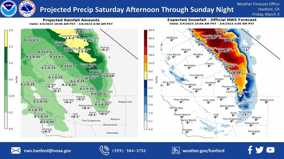
Projected Rainfall for Mariposa and Oakhurst 1.00" to 1.50"
Projected Snowfall for Mariposa: 3-4 inches
Projected Snowfall for Oakhurst: 4-6 inches
Projected Rainfall for Yosemite Valley: 1.50" to 2.00"
Projected Snowfall for Yosemite Valley: 24-30 inches
March 3, 2023 - The National Weather Service Hanford Office reports a storm system will be responsible for snow in the Sierra Nevada and adjacent foothills, as well as a chance of rain in the San Joaquin Valley Saturday afternoon through Sunday night.
Snow levels will start at around 3,000 feet Saturday afternoon, before falling to about 2,000 feet Sunday.
Snow levels should drop to near 1,000 feet Sunday night.
The majority of this precipitation will fall Saturday night and Sunday morning.
Area Forecast Discussion
National Weather Service Hanford CA
1236 AM PST Fri Mar 3 2023
.SYNOPSIS...
Sub-freezing temperatures are expected in parts of the San Joaquin
Valley this morning. A storm system will impact Central California
Saturday afternoon through Sunday night, resulting in snow in the
Sierra Nevada and adjacent foothills, as well as a chance of rain
in the San Joaquin Valley. A warming trend is expected Monday
through at least Thursday.
.DISCUSSION...
Sub-freezing temperatures are anticipated in parts of the San
Joaquin Valley this morning. As a result, a Freeze Warning is in
effect until 9 AM PST this morning. Zonal flow aloft is expected
this afternoon through Saturday morning. Precipitation ahead of
the next storm system will overspread the northern portion of our
service area Saturday afternoon. This storm system will continue
to produce precipitation in Central California Saturday night
through Sunday night. Rain amounts will be less than one tenth of
an inch in the southern portion of the San Joaquin Valley Saturday
afternoon through Sunday night. Rain amounts will be one tenth of
an inch to one quarter of an inch in the western portion of the
San Joaquin Valley Saturday afternoon through Sunday night. Rain
amounts will be one quarter of an inch to one half of an inch in
the eastern portion of the San Joaquin Valley Saturday afternoon
through Sunday night.
Snow levels will start at about 3,000 feet Saturday afternoon,
before falling to around 2,000 feet Sunday. Snow levels should
drop to near 1,000 feet Sunday night. In the Sierra Nevada, snow
amounts of two to three feet are expected above 5,000 feet
Saturday afternoon through Sunday night. Snow amounts of one to
two feet are anticipated from 4,000 feet to 5,000 feet Saturday
afternoon through Sunday night. In the Sierra Nevada foothills,
snow amounts of six to twelve inches are expected from 3,000 feet
to 4,000 feet Saturday afternoon through Sunday night. Snow
amounts of three to six inches are anticipated from 2,000 feet to
3,000 feet Sunday and Sunday night. Snow amounts of one to three
inches are expected from 1,000 feet to 2,000 feet Sunday night.
Here are snow amount probabilities for select locations in the
Sierra Nevada and adjacent foothills Saturday afternoon through
Sunday night:
Yosemite Valley - 99%
Wawona - 98%
Shaver Lake - 95%
El Portal - 89%
North Fork - 75%
Oakhurst - 55%
Mariposa - 26%
A warming trend is expected next week. Be that as it may, by
Thursday afternoon high temperatures will still be around five
degrees below normal for this time of year. The tail end of a
trough of low pressure may brush Central California Thursday,
resulting in a slight chance of precipitation.
&&
.AVIATION...
VFR conditions will prevail across Central California for at least
the next 24 hours.
&&
.AIR QUALITY ISSUES...
None.
&&
.CERTAINTY...
The level of certainty for days 1 and 2 is medium.
The level of certainty for days 3 through 7 is medium.
Certainty levels include low, medium, and high. Please visit
www.weather.gov/hnx/certainty.html for additional information
and/or to provide feedback.
&&
.HNX WATCHES/WARNINGS/ADVISORIES...
Freeze Warning until 9 AM PST this morning for CAZ302-303-
305>307-309>312-314>316.
Winter Storm Warning from 10 AM Saturday to 4 AM PST Monday for
CAZ318-320-323>330.
Source: NWS
