


Includes Fresno, Madera, and Mariposa Counties and Yosemite National Park
Monday Morning Update:
Winter Storm Warning Begins Tuesday Morning for the Sierra Nevada and Foothills Including Fresno, Madera, and Mariposa Counties and Yosemite National Park
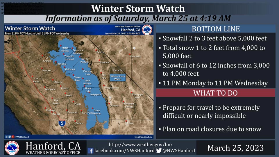
March 25, 2023 - National Weather Service Hanford Office officials report a Winter Storm Watch is in effect for the Sierra Nevada and adjacent foothills above 3,000 feet from 11:00 P.M. Monday until 11:00 P.M. Wednesday.
A Winter Storm Watch means there is potential for significant snow accumulations that may impact travel.
The majority of this snow will fall Tuesday afternoon and Tuesday evening.
Travel could be extremely difficult or impossible. If you plan to travel, consider alternate strategies. If you must travel, remember to carry tire chains, plenty of food, a good deal of water, warm clothing, and a flashlight in your vehicle.
Winter Storm Watch
URGENT - WINTER WEATHER MESSAGE
National Weather Service Hanford CA
452 AM PDT Sat Mar 25 2023

Mariposa-Madera Lower Sierra-Fresno-Tulare Lower Sierra-
South End of the Lower Sierra-Yosemite NP outside of the valley-
Yosemite Valley-San Joaquin River Canyon-Upper San Joaquin River-
Kaiser to Rodgers Ridge-Kings Canyon NP-Grant Grove Area-
Sequoia NP-South End of the Upper Sierra-
Including the cities of Bass Lake, Coarsegold, Fish Camp,
Oakhurst, North Fork, Auberry, Camp Nelson, Tuolumne Meadows,
Wawona, Yosemite Valley, Devils Postpile, Florence Lake,
Lake Thomas Edison, Lake Wishon, Huntington Lake, Shaver Lake,
Cedar Grove, Grant Grove, Hume Lake, Giant Forest, Lodgepole,
and Johnsondale
452 AM PDT Sat Mar 25 2023

...WINTER STORM WATCH REMAINS IN EFFECT FROM MONDAY EVENING
THROUGH WEDNESDAY EVENING ABOVE 3000 FEET...

* WHAT...Heavy snow possible above 3000 feet. Total snow of two to
  three feet conceivable above 5000 feet. Snow accumulations of
  one to two feet possible from 4000 feet to 5000 feet. Total snow
  of six to twelve inches conceivable from 3000 feet to 4000
  feet. Winds could gust as high as 50 mph on exposed ridgetops
  and along the crest.

* WHERE...The Sierra Nevada and adjacent foothills above 3000
  feet.

* WHEN...From Monday evening through Wednesday evening.

* IMPACTS...Travel could be very difficult to impossible. The
  hazardous conditions may impact the morning or evening commute.

PRECAUTIONARY/PREPAREDNESS ACTIONS...
Source: NWS
