


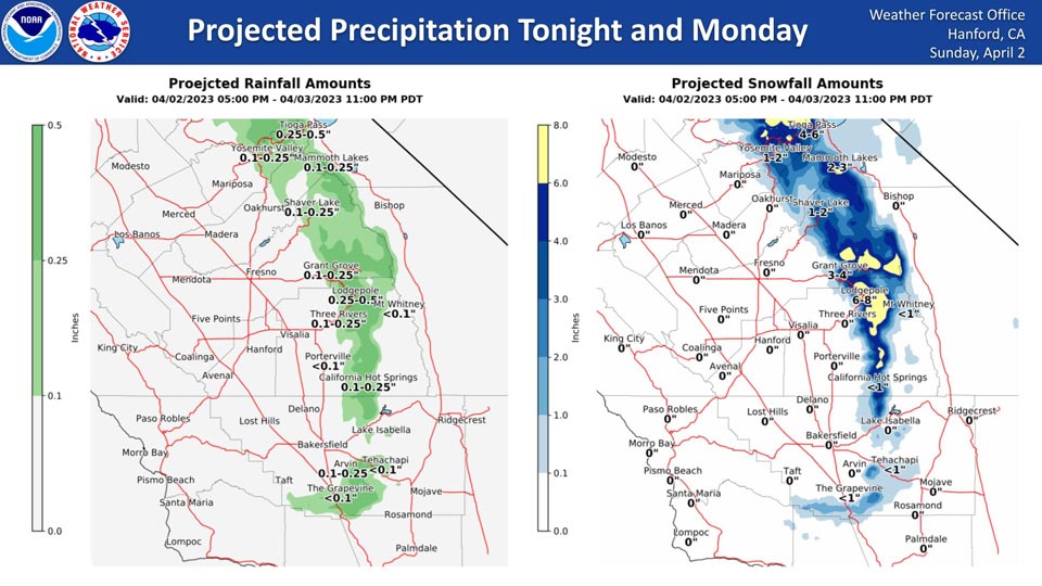
Mariposa and Oakhurst: Zero Projected Rainfall Precipitation
Yosemite Valley Projected Rainfall Precipitation: 0.10" to 0.25" - Possible 1" to 2" of snow
April 2, 2023 - National Weather Service Hanford office officials report an upper trough will drop into Northern California tonight and into the Great Basin on Monday, bringing light precipitation to the Sierra Nevada and the mountains of Kern County.
The majority of this precipitation will fall on Monday morning.
Area Forecast Discussion
National Weather Service Hanford CA
914 AM PDT Sun Apr 2 2023
.SYNOPSIS...
A trough of low pressure will be responsible for strong, gusty
winds in the San Joaquin Valley and light precipitation in the
Sierra Nevada and adjacent foothills tonight and Monday. Farther
south, damaging wind gusts are expected in the Tulare County and
Kern County mountains, as well as the Kern County desert. A
warming trend is anticipated Wednesday through next weekend.
&&
.DISCUSSION...
A trough of low pressure will deepen over Northern California
tonight. This trough of low pressure will continue to intensity as
it pass eastward through Central California Monday. The trough of
low pressure will enter the Great Basin Monday night.
Precipitation wise, there is a chance of rain in the Sierra
Nevada foothills below 3,000 feet and a chance of snow above 3,000
feet in the Sierra Nevada and adjacent foothills tonight and
Monday. Snow amounts will be an inch or less from 3,000 feet to
4,000 feet. Total accumulations will be one to two inches from
4,000 feet to 5,000 feet. Snow amounts will be two to four inches
from 5,000 feet to 6,000 feet. Total snow accumulations will be
four to eight inches above 6,000 feet. In Kern County, an inch or
less of snow is possible along Interstate 5 over Tejon Pass and
along Highway 58 over Tehachapi Pass Monday morning.
Monday will be windy and much cooler compared to today. Maximum
temperatures Monday afternoon will be around ten degrees cooler
than today. Quite cool conditions will persist into Tuesday. High
temperatures Tuesday afternoon will be about ten degrees below
normal for this time of year. A ridge of high pressure will build
over the Western United States Wednesday through the upcoming
weekend. As a result, a warming trend is expected. Maximum
temperatures each afternoon Wednesday through Sunday will be
around five degrees warmer than the previous day. By Friday
afternoon, temperatures will reach seasonal values. High
temperatures Sunday afternoon should be seven to nine degrees
above normal for this time of year. Here are probabilities of
maximum temperatures of 80 degrees or higher for select locations
in the San Joaquin Valley on Sunday, April 9th, 2023:
Fresno - 71%
Madera - 71%
Hanford - 71%
Delano - 71%
Reedley - 71%
Lemoore - 71%
Visalia - 66%
Merced - 66%
Bakersfield - 61%
Porterville - 61%
&&
.AVIATION...
VFR conditions will prevail in the San Joaquin Valley through at
least the next 24 hours. MVFR or lower conditions, along with
mountain obscurations, are expected in the Sierra Nevada tonight
and Monday.
&&
.AIR QUALITY ISSUES...
None.
&&
.CERTAINTY...
The level of certainty for days 1 and 2 is high.
The level of certainty for days 3 through 7 is medium.
Certainty levels include low, medium, and high. Please visit
www.weather.gov/hnx/certainty.html for additional information
and/or to provide feedback.
&&
.HNX WATCHES/WARNINGS/ADVISORIES...
High Wind Warning until 5 AM PDT Tuesday for CAZ322-331>339.
Wind Advisory from 1 PM to 11 PM PDT Monday for CAZ300>316.
Source: NWS
