


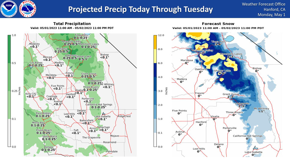
Projected Precipitation for Mariposa, Oakhurst and Yosemite Valley: 0.25" to 0.50"
May 1, 2023 - National Weather Service Hanford Office officials report a storm system just off the coast of the Pacific Northwest will move southward to just off the coast of California Monday afternoon through Tuesday, resulting in a chance of precipitation in the Sierra Nevada and a slight chance of precipitation in the San Joaquin Valley.
Snow levels will start at around 7,000 feet this afternoon, before dropping to about 5,000 feet tonight.
The majority of this precipitation will fall tonight into Tuesday morning.
Area Forecast Discussion
National Weather Service Hanford CA
123 AM PDT Mon May 1 2023
.SYNOPSIS...
Cooler than average temperatures for most of this week. High
winds today for the area with a High Wind Advisory in the Kern
County Desert until Tuesday morning. Chance of showers Tuesday
through Thursday for the Valley mainly in the afternoon. Snow
likely in the Sierra Nevada through Saturday night.
&&
.DISCUSSION...
After a very warm weekend with temperatures getting
up to the mid to upper 90s on Friday and Saturday, we have a cooling
trend due to a trough that is moving in today. 0Z GEFS and European
model ensembles are in strong agreement that the trough will hang
around for most of the week which will keep temperatures below
average until the weekend. However, the ensembles diverge as to the
timing and movement of the trough after Friday. The trough is going
to persist as the ridge that was over us will strengthen and persist
over the Plains. A High Wind Advisory is in effect for the Kern
County desert as wind gusts up to 50 mph is expected there through
early Tuesday morning due to the trough moving in.
This colder trough will bring a few showers to the area and snow to
the Sierra Nevada due to the instability with the colder
temperatures that we will experience after the major heat. NBM
probabilistic models have between 30 and 50 percent chance of at
least 0.05 inches of rain from 5 PM Wednesday to 5 PM Thursday. Up
in the Sierra Nevada, 2 to 5 inches of snow is expected over the the
week above 5,000 feet.
Elevated convection is likely in the Sierra Nevada this week.
However, with snow levels hovering between 5,000 and 6,000 feet,
areas of higher snow melt may occur due to the effect of rain on
snow. This potential additional snow melt would increase runoff into
local creeks and rivers which increases the risk of flooding.
&&
.AVIATION...
VFR conditions will prevail across the central California interior
for the next 24 hours.
&&
.AIR QUALITY ISSUES...
None.
&&
.CERTAINTY...
The level of certainty for days 1 and 2 is high.
The level of certainty for days 3 through 7 is medium.
Certainty levels include low...medium...and high. Please visit
www.weather.gov/hnx/certainty.html for additional information
and/or to provide feedback.
&&
.HNX WATCHES/WARNINGS/ADVISORIES...
Wind Advisory from noon today to 5 AM PDT Tuesday for CAZ337>339.
Flood Watch through Tuesday morning for CAZ323-324.
Source: NWS
