


Includes Fresno, Merced, Madera and Mariposa Counties and Yosemite National Park
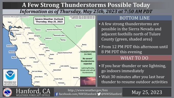
May 25, 2023 - National Weather Service Hanford Office reports a few strong thunderstorms are possible in the Sierra Nevada and adjacent foothills north of Tulare County from 12:00 P.M. this afternoon until 8:00 P.M. this evening.
In addition to lightning, any thunderstorm can produce intense rain rates, leading to localized flooding.
Area Forecast Discussion
National Weather Service Hanford CA
311 AM PDT Thu May 25 2023
.SYNOPSIS...Temperatures will be near average today and Friday
before warming up a little on Saturday. Afternoon thunderstorms
are possible over the Sierra Nevada each day through the middle of
next week. High river flows will remain an issue through at least
the middle of next week.
&&
.DISCUSSION...An upper trough now prevails near the western CONUS
coast. This feature brought much cooler temperatures to our area
on Wednesday and will maintain cooler temperatures across our
area today and Friday although temperatures are expected to rise
back up to climatological normals today. The trough also brought
drier air into our area as mountain convection was shut off as
the mid/upper level moisture that had fueled the thunderstorms
over the Sierra Nevada and eastern Kern County last weekend
through early this week was pushed well to the east of our area.
The trough will provide for enough instability today over the
Sierra Nevada for showers and scattered thunderstorms. WRF is
indicating LI/s between -3 and -5 DEG C and CAPES between 1200
and 1800 J/kg this afternoon over the Sierra Nevada north of
Kings Canyon this afternoon. With the trough moving very slowly
eastward through Friday expect little change with temperatures
near daily climatological normals and another afternoon of
showers and scattered thunderstorms over the Sierra Nevada. Latest
NBM probabilistic guidance is showing between a 50 and 70 percent
chance of measurable precipitation for most of Yosemite Park
today and again on Friday.
The trough is progged to lift out by Saturday which will result
in a slight warming trend and a reduced threat of mountain
convection. The medium range models and many of their ensemble
members are now showing better consensus with another trough
dropping into CA on Sunday and maintaining more seasonal
temperatures through next Tuesday. A slight warming trend is
progged for the middle of next week as the trough moves out of
our region.
&&
.AVIATION...VFR conditions will prevail throughout the Central CA
interior for the next 24 hours. However, MVFR and mountain
obscuring IFR conditions may be possible due to showers and
thunderstorms above the Sierra Nevada from 20Z Thu until 03Z Fri.
&&
.AIR QUALITY ISSUES...None.
&&
.CERTAINTY...
The level of certainty for days 1 and 2 is medium.
The level of certainty for days 3 through 7 is medium.
Certainty levels include low...medium...and high. Please visit
www.weather.gov/hnx/certainty.html for additional information
and/or to provide feedback.
&&
.HNX WATCHES/WARNINGS/ADVISORIES...None.
Source: NWS
