


California and National Drought Summary for September 22, 2015
Summary
Large sections of the nation experienced dry weather, reducing topsoil moisture but promoting summer crop maturation and harvesting. On the Plains, some producers awaited rain before planting winter wheat. Pastures in portions of the Southern and Mid-Atlantic States continued to suffer from the effects of late-summer and early-autumn dryness. In contrast, locally heavy showers soaked Florida’s peninsula and the immediate southern Atlantic Coast. Significant rain also fell—albeit briefly—in parts of the Midwest, providing localized relief from recent dryness. Above-normal temperatures dominated the Plains and upper Midwest, favoring fieldwork and helping to push summer crops toward maturity. The late-season warmth also extended across the Great Lakes region and into the Northeast. Meanwhile, cool air settled across the southeastern and northwestern U.S. for several days, helping to hold weekly temperatures more than 5°F below normal in a few locations. Elsewhere, locally heavy showers dotted the West, with the most significant rain falling in the lower Southwest, southern California, and the northern Intermountain region. California’s rain, heaviest along and near the coast, fell mostly on September 15 in conjunction with tropical moisture associated with former Hurricane Linda, while Southwestern rainfall was courtesy of Tropical Depression 16E later in the period.Alaska, Hawaii, and Puerto Rico
In Alaska, 1 to 2 inches of rain (locally more) during the period maintained the recent trend of wet weather, which coupled with assessments from the field supported the reduction of Abnormal Dryness (D0) and Moderate Drought (D1) in eastern portions of the state. Likewise in Hawaii, reports from the field indicated record September wetness in Kona which supported a significant reduction of the Big Island’s D0. In Puerto Rico, moderate heavy rainfall (2-8 inches) eased drought intensity and coverage over northern and western portions of the island, though the core Extreme Drought (D3) areas generally missed out on the rain.Central Plains
Dry, unseasonably warm weather maintained or worsened dryness over the central Plains. With sunny skies and temperatures topping 80°F from Colorado into Kansas and central Nebraska, Abnormal Dryness (D0) and Moderate Drought (D1) remained or expanded. Precipitation deficits are most pronounced at 60 days, with rainfall tallying less than 50 percent of normal in D0 areas, and locally less than 25 percent of normal in the D1 region of central Kansas. The rain which has since fallen over the central Plains will be accounted for in next week’s drought assessment, as the data cutoff for inclusion into the assessment is Tuesday morning.Mid-Atlantic and Northeast
Warmer- and drier-than-normal weather prevailed over much of the region during the 7-day period, causing soil moisture and streamflows to decline further. Abnormal Dryness (D0) expanded from West Virginia and Maryland northeastward into New England, though light to moderate showers (0.5 to 1 inch, locally more) across the interior Northeast mitigated this week’s D0 expansion somewhat. In eastern New England, Moderate Drought (D1) expanded northward across Massachusetts, Rhode Island, and Maine, where streamflows below the 5th percentile coincided with areas which have received 50 percent of normal rainfall or less over the past 90 days.Midwest and lower Ohio Valley
Late-season heat and dryness persisted, causing rapidly declining conditions after a favorably wet start to the summer. Temperatures during the period averaged 4 to 8°F above normal, which coupled with a lack of rain in southern and western portions of the region led to an expansion of Abnormal Dryness (D0) and Moderate Drought (D1). Despite the generally favorable precipitation signal over the longer 90-day timeframe, pronounced short-term dryness (60-day rainfall near or below half of normal) led to the introduction of D0 in central Missouri, west-central Illinois, and along and south of the Ohio River. In addition, the short-term Standardized Precipitation Index (SPI) indicated many locales are approaching or entering the early stages of drought, with pockets of D1 introduced in southern Indiana, central and eastern Kentucky, and the northern Tennessee border. Despite the heat and dryness, a swath of moderate to heavy rain (1-3 inches, locally more) eased D1 and D0 in northeastern Iowa and environs.Northern Plains and Dakotas
Warm, dry conditions in eastern and southern portions of the region contrasted with showery, chilly weather farther west. Despite year-to-date precipitation averaging near to above normal, Abnormal Dryness (D0) expanded over southeastern South Dakota and immediate environs where 90-day rainfall has totaled 60 percent of normal or less (locally less than 40 percent). Similar precipitation deficits were noted in the newly introduced D0 over eastern Wyoming, while 60-day rainfall totaling a meager 15 to 40 percent of normal led to the expansion of Abnormal Dryness into southwestern South Dakota and northwestern Nebraska. Farther west, below-normal temperatures were accompanied by periods of rain (1-2 inches, locally more), though rain was generally not sufficient to alleviate longer-term (9 months and beyond) precipitation deficits.Southeast and Delta
Highly variable weather prevailed, with locally heavy rainfall in southeastern areas contrasting with unfavorable dryness farther north and west. A stalled storm system coupled with abundant tropical moisture triggered heavy downpours in southern Florida (2-6 inches, locally more) as well as eastern Georgia and central South Carolina (1-3 inches), reducing drought intensity and coverage in areas with the heaviest rainfall. Meanwhile, western portions of North Carolina missed out on the rain, with Severe Drought (D2) expanded to account for 90-day rainfall less than 50 percent of normal and streamflow levels ranked in the lowest 5th percentile. Mostly dry, warm weather prevailed over the central Gulf Coast States, with drought persisting or intensifying in these locales. Most notably, Extreme Drought (D3) expanded over northwestern Louisiana and central Mississippi, reflecting 90-day rainfall as low as 25 percent of normal.Southern Plains and Texas
Despite areas of beneficial rain in the north and west, the overall trend toward intensifying “flash drought” continued. After record-setting rainfall over central and eastern Texas in May, sharply drier weather over much of the state during the summer resulted in rapidly deteriorating conditions despite longer-term precipitation surpluses. To illustrate, the 6-month precipitation in Texas’ core Extreme Drought (D3) area from just east of Austin to Nacogdoches still stands at 120 to 150 percent of normal. However, over the past 3 months, this same area has received a meager 10 to 20 percent of normal. With another hot, dry week, the drought intensity and coverage expanded over much of the Lone Star State. Exceptions included the Red River Valley, where rain totals greater than an inch resulted in localized reductions in drought intensity and coverage. Farther north, widespread moderate to heavy showers (1-3 inches) eased Abnormal Dryness (D0) and Moderate Drought (D1) over central and southern Oklahoma. At the end of the period, showers and thunderstorms were overspreading northern Texas and western Oklahoma, areas generally devoid of drought at this time.Western U.S.
The overall trend toward drought persistence continued, though pockets of beneficial rain were noted in the northern Rockies, Pacific Northwest, and lower Four Corners. The west was generally cooler than normal, easing stress on pastures, crops, and livestock.In the north, most of the region’s core Extreme Drought (D3) areas were dry. However, moderate to heavy rain on Washington’s Olympic Peninsula (2-4 inches, locally more) staved off D3 expansion. Farther east, 1 to 3 inches of rain eased drought intensity and coverage over central and southern Idaho, though northern portions of the state remained dry.
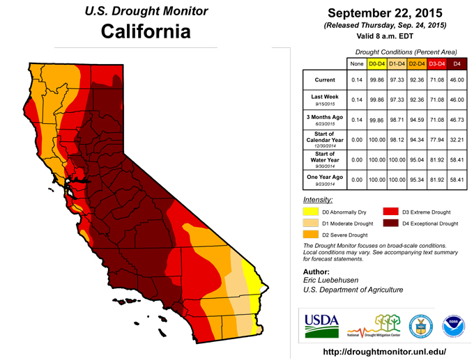
Across the California and the Great Basin, drought remained unchanged as the region continued through its climatologically dry summer season. Some showers associated with the remnants of Hurricane Linda were noted along the coastal regions of southern California, though the totals (mostly less than 2 inches) were not sufficient to warrant any reductions to the Extreme (D3) to Exceptional (D4) Drought.
In the Four Corners States, a late-season surge in monsoon rainfall was enhanced by moisture associated with Tropical Depression 16E, whose remnants tracked from Baja, Mexico onto the central Plains. While passing over the Southwest, the remnants of 16E generated 1 to as much as 4 inches of rain, resulting in reductions of Moderate (D1) and Severe Drought (D2) coverage in southeastern Arizona and southwestern New Mexico.
Looking Ahead
A cold front infused with tropical moisture will remain the focus for locally heavy showers, primarily from the southern High Plains into the upper Midwest. Additional rainfall in the vicinity of the front could reach 1 to 3 inches in a few spots. Meanwhile, a low-pressure system will drift westward toward the middle and southern Atlantic Coast, bringing a mid- to late-week increase in rainfall. Five-day rainfall totals could reach 2 to 5 inches or more in the Carolinas and parts of neighboring states. Warm, mostly dry weather will cover the remainder of the country, except for some late-week showers in the Northwest. The NWS 6- to 10-day outlook for September 29 – October 3 calls for the likelihood of above-normal temperatures nationwide, with near-normal temperatures confined to the Pacific Coast States. Meanwhile, wetter-than-normal conditions over the Southeast and from the north-central Plains into the western Corn Belt will contrast with drier than normal conditions across the central and eastern Great Lakes Region and from the lower Four Corners into central and northern Texas.Author(s):
Eric Luebehusen, U.S. Department of Agriculture
Dryness Categories
D0 ... Abnormally Dry ... used for areas showing dryness but not yet in drought, or for areas recovering from drought.Drought Intensity Categories
D1 ... Moderate DroughtD2 ... Severe Drought
D3 ... Extreme Drought
D4 ... Exceptional Drought
Drought or Dryness Types
S ... Short-Term, typically <6 months (e.g. agricultural, grasslands)L ... Long-Term, typically >6 months (e.g. hydrology, ecology)
Source: The National Drought Mitigation Center
