


Includes Mariposa County, Madera County, and Yosemite National Park
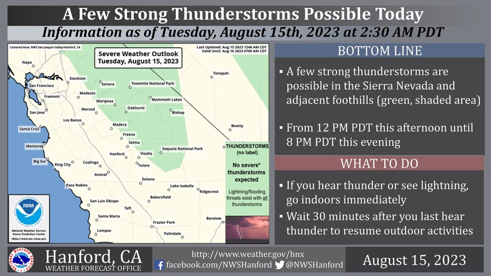
August 15, 2023 - The National Weather Service Hanford Office reports a few strong thunderstorms are possible in the Sierra Nevada and adjacent foothills from 12:00 P.M. this afternoon until 8:00 P.M. this evening.
In addition to dangerous cloud to ground lightning strikes, any thunderstorm can produce strong, gusty winds and small hail.
Area Forecast Discussion
National Weather Service Hanford CA
241 AM PDT Tue Aug 15 2023
.SYNOPSIS...
A chance for showers and thunderstorms will continue across the
Sierra Nevada each afternoon and evening this week. Temperatures
will remain around 10 degrees above normal through Thursday with
widespread triple digit heat across the lower elevations. A Heat
Advisory remains in effect for the San Joaquin Valley, the lower
Sierra Foothills, and the Coastal Range through Thursday.
&&
.DISCUSSION...
An upper low continues to spin just off of the central California
coast while an upper high is centered over the Four Corners region.
The upper low continued a moist southeast flow aloft which combined
with daytime heating produced showers and thunderstorms across the
Sierra Nevada. The upper high brought a return to widespread triple
digit heat to the lower elevations on Monday.
Little changes in the synoptic pattern are expected over the next
few days. The upper ridge will continue to provide temperatures
around 10 degrees above normal. Triple digit highs will produce a
moderate heat risk across lower elevations. A Heat Advisory remains
in effect for the San Joaquin Valley, lower Sierra Foothills, and
Coastal Range through Thursday. Medium range models agree with the
ridge moving downstream over the southern Plains by Friday as the
upper low off the coast fills and shifts inland. This will lower
temperatures several degrees with forecast highs in the middle to
upper 90s across the SJ Valley. A little more cooling on Saturday
is expected to lower temperatures to near normal for this time of
the year. Little changes are forecast Sunday into early next week.
A moist southeast flow aloft will continue through the week due to
the proximity of the upper low. Hi-res models show convection over
the Sierra Nevada each afternoon and evening. Convection looks to
extend down into the Kern County mountains and desert this weekend
as the low opens up. Ensembles hint that more tropical moisture is
possible early next week that could produce widespread convection.
&&
.AVIATION...
Areas of MVFR and local mountain obscuring IFR in showers and
thunderstorms over the Sierra Nevada from 19Z Tuesday through
06Z Wednesday. Otherwise, VFR conditions will prevail across
the Central CA interior for at least the next 24 hours.
&&
.AIR QUALITY ISSUES...
None.
&&
.CERTAINTY...
The level of certainty for days 1 and 2 is high.
The level of certainty for days 3 through 7 is medium.
Certainty levels include low...medium...and high. Please visit
www.weather.gov/hnx/certainty.html for additional information
and/or to provide feedback.
&&
.HNX WATCHES/WARNINGS/ADVISORIES...
Heat Advisory until 11 PM PDT Thursday for CAZ300>317-319-321.
Source: NWS
