


Possible Thunderstorms in the Sierra Nevada and the Foothills of Mariposa, Madera and Fresno Counties Including Yosemite National Park
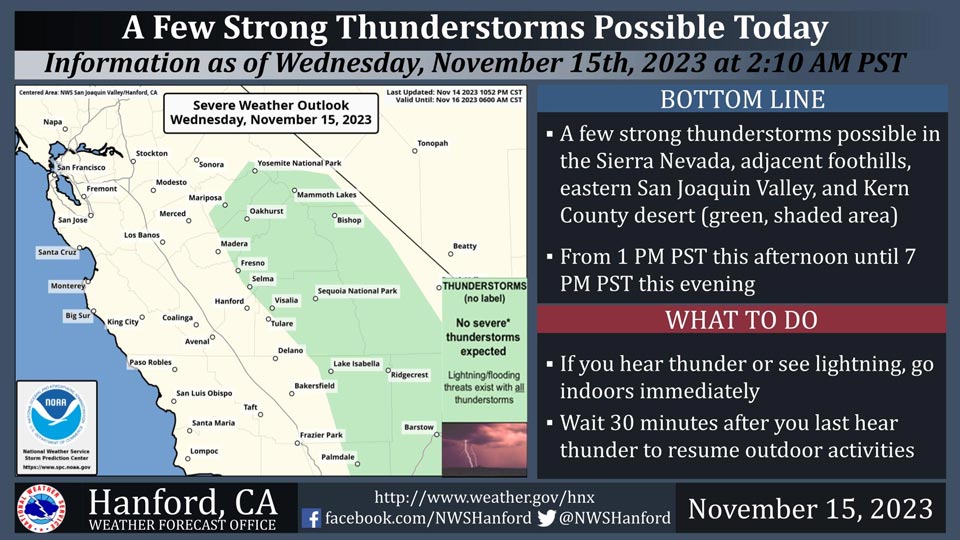
November 15, 2023 - National Weather Service Hanford Office officials report a few strong thunderstorms are possible in the Sierra Nevada, adjacent foothills, eastern San Joaquin Valley, and Kern County desert from 1:00 P.M. this afternoon until 7:00 P.M. this evening.
Wind gusts near 45 miles per hour and small hail are a couple of hazards associated with strong thunderstorms.
In addition to dangerous cloud to ground lightning strikes, any thunderstorm can produce intense rainfall rates, leading to localized flooding.
Area Forecast Discussion
National Weather Service Hanford CA
200 AM PST Wed Nov 15 2023
.SYNOPSIS...Precipitation will spread over Central California
from south to north this afternoon this evening and continuing
into Thursday morning. Another period of rain and mountain snow
is expected between Friday afternoon and Saturday evening.
Temperatures will continue to run slightly above normal for this
time of year.
&&
.DISCUSSION...IR imagery is showing a weak frontal system
approaching the CA coast. SREF is showing a stream of mid level
moisture ahead of it will reach central CA by this afternoon and
spread northward into the evening bringing a period of widespread
light precipitation to our area. The main concern for today;
however, the potential for downslope southerly winds in the
Grapevine and Frazier Park areas where gusts to 55 mph will be
possible until early this evening. A Wind Advisory remains in
effect for these areas between 400 AM PST this morning and 700 PM
PST this evening. Another concern is that the NBM continues to
suggest that there will be enough instability over much of the
Sierra Nevada and adjacent foothills this evening for a slight
chance of thunderstorms. QPF progs are indicating a tenth to a
quarter of an inch of rainfall for much of the San Joaquin Valley
for tonight and Thursday while much of the Sierra Nevada will
pick up between a half inch of an inch of liquid precipitation
during this same time span. Snow levels are expected to be between
8500 and 9500 feet for much of this event as a warm airmass
prevails over our area.
RH progs are showing mid level drying taking place between
Thursday evening and Friday morning although there will be enough
instability for chances of light showers across much of our area
during this period. With a mild airmass remaining over the region,
temperatures will remain above daily climatological normals for
mid November.
Meanwhile the cutoff upper low near 130W will finally get pushed
eastward by Friday and is expected to move across our area by
Saturday which will provide for another period of widespread
precipitation across our area between Friday afternoon and
Satruday evening. However, QPF is continuing to trend lower with
this system and snow levels are expected to be between 7500 and
8500 feet. Up to an additional foot of new snow remains possible
in the Sierra Nevada above 8500 feet Friday night and Saturday.
Probabilistic guidance continues to indicate a 30 to 40 percent
probabilities for minor winter weather impacts due to the
accumulating snowfall in the Sierra Nevada on Saturday.
The medium range models are in good agreement with the low moving
east of our area Saturday night and Sunday with some lingering
upslope precipitation remaining possible over the valley facing
slopes of the Sierra Nevada and Tehachapi Mountains through midday
Sunday. Ensemble means are showing ridging returning to central
CA on Monday and Tuesday which will bring a return to dry weather
and a warming trend. However, with clear skies, light winds and
inversion conditions, dense fog will become possible in the San
Joaquin Valley on Monday and Tuesday mornings.
&&
.AVIATION...In the San Joaquin Valley and West Side Hills,
increasing areas of MVFR with local IFR in rain and low clouds
after 18Z Wed. In the Sierra Nevada, adjacent foothills and
Tehachapi Mountains, increasing areas of MVFR with local IFR in
perception and low clouds after 18Z Wed with widespread mountain
obscuring IFR prevailing after 00Z Thu. Otherwise, VFR conditions
will prevail across the central Central CA interior for at least
the next 24 hours.
&&
.AIR QUALITY ISSUES...On Wednesday November 15 2023,
Fireplace/Wood Stove Burning Status is: No Burning Unless
Registered in Fresno, Kern, and Kings Counties. Burning
Discouraged in Madera, Merced, and Tulare Counties, and Kern
(Greater Frazier Park Area) and Sequoia National Park and Forest.
&&
.CERTAINTY...
The level of certainty for days 1 and 2 is medium.
The level of certainty for days 3 through 7 is medium.
Certainty levels include low...medium...and high. Please visit
www.weather.gov/hnx/certainty.html for additional information
and/or to provide feedback.
&&
.HNX WATCHES/WARNINGS/ADVISORIES...
Wind Advisory from 4 AM early this morning to 7 PM PST this
evening for CAZ335-336.
Source: NWS
