


California and National Drought Summary for November 28, 2023
Summary
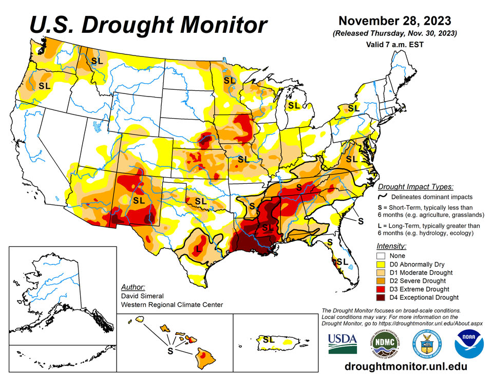
November 30, 2023 - This U.S. Drought Monitor (USDM) week saw some minor expansion of drought across areas of the West (Colorado, Idaho, Montana, Wyoming) and Midwest (Illinois, Indiana, Missouri), while conditions improved on the map in drought-affected areas of the South (Mississippi, Oklahoma, Tennessee, Texas), Southeast (Alabama, Carolinas, Florida, Virginia), Northeast (Delaware, New Jersey, Pennsylvania), High Plains (Kansas), and the West (Montana, New Mexico). For the week, cooler-than-normal temperatures prevailed across most of the conterminous U.S. with the largest departures observed across areas of the Intermountain West, central and southern Plains, and Texas where temperatures were 6 to 10 degrees below normal. In terms of precipitation, light to heavy snowfall accumulations (2 to 36 inches) were observed across areas of the central and southern Plains, Upper Midwest, and the Northeast with the heaviest accumulations falling in the Northeast. In areas of the South, Southeast, and Mid-Atlantic, light to heavy precipitation accumulations (1 to 4 inches) were observed leading to targeted improvements in drought-affected areas on the map. Out West, moderate to heavy snowfall accumulations were observed in the mountain ranges of central Utah and western Colorado as well as in northern portions of Arizona and New Mexico. The heaviest accumulations (up to 36 inches) were observed in the San Juan Mountains of southwestern Colorado. Overall, early-season snowpack conditions across the West have been below normal apart from some drainage basins (6-digit HUCs) in the Great Basin, Lower Colorado, and Rio Grande basins. According to the Natural Resources Conservation Service (NRCS) SNOTEL network (11/28), region-wide (2-digit HUCs) percent of median snow water equivalent (SWE) levels were as follows: Pacific Northwest 53%, Missouri 62%, California 39%, Great Basin 62%, Upper Colorado 59%, Lower Colorado 100%, Rio Grande 53%, and Arkansas-White-Red 55%. In the Hawaiian Islands, locally heavy showers and thunderstorms associated with an ongoing Kona Low system are bringing much-needed moisture to drought-affected areas of the island chain this week.
Northeast
For the week, some minor improvements were made on the map in drought-affected areas of Pennsylvania, New Jersey, Delaware, and Maryland in response to beneficial rainfall during the past 14-day period (accumulations ranging from 2 to 4 inches). In other parts of the region, some locally heavy snowfall accumulations were observed in areas downwind of the Great Lakes in Upstate New York as well as in Vermont with 3-day (through the morning of 11/29) accumulations ranging from 6 to 36 inches, according to the National Weather Service (NWS) National Operational Hydrologic Remote Sensing Center (NOHRSC). Furthermore, NWS NOHRSC regional snow analysis reports that the Northeast Region is 51.3% covered by snow with an average snow depth of 2.3 inches and a maximum depth of 23.5 inches. For the week, average temperatures were below normal across the region with departures ranging from 1 to 5 degrees F below normal.
Southeast
During the past week, light to moderate rainfall accumulations (ranging from 1 to 4 inches) were observed across areas of the region, with the highest accumulations observed in isolated areas of Virginia, North Carolina, and northern Florida. On the map, targeted improvements were made in all states within the region. Despite the recent improvements, rainfall deficits within the past 30-day period range from 1 to 4 inches across much of the region with the greatest shortfalls observed in the northern portion of Alabama and Georgia as well as in western North Carolina. In terms of drought-related impacts, the National Drought Mitigation Center’s (NDMC) Condition Monitoring Observer Reports (CMOR) recorded hundreds of impact reports from across Alabama and Georgia during the past 30-day period. Average temperatures across most of the region were below normal (1 to 6 degrees F), with the greatest departures observed in Alabama and northern Florida.
South
In the South, precipitation during the past 14-day period led to improvements on the map in isolated areas of Mississippi, Tennessee, Oklahoma, and Texas. However, significant precipitation deficits remain across areas of the region including along the Gulf Coast regions of Texas, Louisiana, and Mississippi where 6-month shortfalls range from 8 to 20+ inches. According to the latest U.S Department of Agriculture (USDA) Weekly Weather and Crop Progress Bulletin (11/26), the percentage of topsoil in Louisiana rated short to very short was 72%, while neighboring Mississippi was rated 66% short to very short. In Texas, statewide reservoir conditions were at 68% full (11/29), according to Water Data for Texas. Moreover, the best reservoir conditions (% full) were observed in the East Texas (86.6%), North Central (84.1%), and Upper Coast (84.9%) climate regions while the poorest conditions were reported in the South (21%), Edwards Plateau (31.1%), and High Plains (36.9%) regions. Looking at streamflow conditions in Louisiana and Mississippi, the U.S. Geological Survey (USGS) is reporting numerous streams and rivers with flows below the 10th percentile (11/29). In terms of drought-related impacts during the past 30 days, there has been a significant decline in the number of impact reports coming into the NDMC CMOR system.
Midwest
For the week, light to moderate precipitation accumulations, including snowfall, were observed across areas of the region with the highest amounts observed in eastern portions of Kentucky and Ohio. On the map, continued dry conditions led to additional expansion of areas of drought in Missouri, Illinois, and Indiana where various drought indicators, including soil moisture (North American Land Data Assimilation System [NLDAS]) and streamflows (USGS), are showing well below normal levels with values dipping below the 10th percentile. According to the latest USDA Weekly Weather and Crop Progress Bulletin (11/26), the percentage of topsoil rated short to very short is as follows: Iowa 67%, Missouri 55%, Illinois 47%, and Indiana 42%. In terms of precipitation, 30-day departures from normal range from 1 to 4 inches across the region with the greatest departures observed in southern Illinois and southeastern Missouri. Looking at snowpack conditions, the NWS NOHRSC reports 61% of the Northern Great Lakes Region is covered by snow with an average depth of 1.1 inches and a maximum of 10.5 inches. Average temperatures for the week were below normal (1 to 8 degrees F) across the region with the greatest anomalies observed across the western half of the region.
High Plains
On this week’s map, some minor improvements were made in areas of Kansas in response to improving conditions during the past 30-60 days, including beneficial snowfall observed over the Thanksgiving holiday weekend. Elsewhere, degradations were made in areas of eastern Colorado where drier-than-normal conditions have prevailed during the past 30-60-day period. In the Dakotas, conditions on the map remained status quo. In terms of snowpack conditions, the NWS NOHRSC reports the Upper Midwest Region (which includes the Dakotas and eastern portions of Montana) is currently 3.1% covered by snow as compared to 66.3% last month. Average temperatures for the week were below normal (2 to 8 degrees F) with the greatest departures observed in the plains of Colorado and Wyoming as well as in Kansas.
West
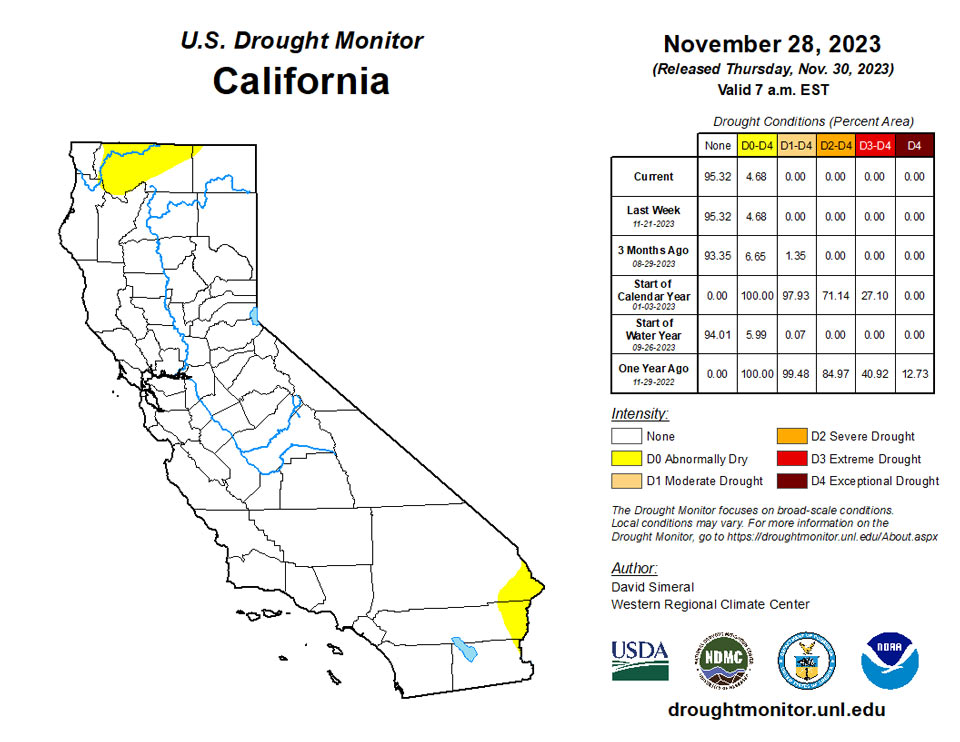
On the map, improvements were made across areas of the Southwest and Pacific Northwest including New Mexico, Oregon, and Montana. In northern New Mexico, areas of Extreme Drought (D3) were reduced in response to recent precipitation (past 14-day period) including high-elevation snowfall in the Nacimiento and Sangre de Cristo ranges. In Montana, a mix of improvements and degradations were made on this week’s map, including the removal of an area of Moderate Drought (D1) in north-central Montana where conditions have improved across various metrics during the past 60-day period. In northeastern Oregon, areas of Moderate Drought (D1) were trimmed back around the Blue Mountains where Water-Year-to-Date precipitation (10/1) has been above normal. In south-central Colorado, areas of Severe (D2) and Extreme (D3) drought expanded slightly in areas where month-to-date precipitation has been well below normal. Overall, the West has gotten off to a slow start in terms of snowpack conditions across the region except for some basins in the southern tier of the region. In California, the California Cooperative Snow Surveys reports statewide snowpack conditions at 30% of normal for the date (11/29). For the week, average temperatures were below normal across most of the region with areas of the Intermountain West experiencing departures ranging from 4 to 10 degrees F below normal.
Caribbean
In Puerto Rico, some minor re-positioning of the current D0 and D1 areas occurred on this week’s map to reflect the latest conditions including analysis of rainfall, soil moisture, and streamflow data.
A dry, stable air mass, associated with a high-pressure ridge, continued across the U.S. Virgin Islands (USVI) during this U.S. Drought Monitor (USDM) week (November 22-28). The remnants of an old cold front triggered scattered showers, but the ridge inhibited widespread development of these showers and kept the rain localized. Based on data available at the time of this report, weekly rainfall totals ranged from less than an inch to over an inch, with a few stations on St. Croix receiving over 2 inches.
According on USGS well observations, groundwater levels continued rising on St. John, continued falling on St. Thomas, and rose slightly this week on St. Croix. The depth to water level was 5.10 feet on St. John and 6.57 feet on St. Thomas, both of which are in the top third of the recent historical record, but 33.14 feet on St. Croix, which is in the lowest third of the historical record. Satellite observations (VHI) still showed some stressed vegetation on the three USVI islands.
With year-to-date precipitation totals still well below normal, long-term moderate drought (D1-L) continued on St. Croix. A very dry November coupled with long-term precipitation deficits resulted in St. Thomas having short- and long-term severe drought (D2-SL), while St. John continued with a D-Nothing status (no drought or abnormal dryness).
Pacific
In Alaska, drought-free conditions remain across the state. In terms of snowfall, Anchorage broke the monthly snowfall record for November on 11/17 with 39.1 inches—surpassing the previous November record set back in 1994 with 38.8 inches. Elsewhere in the state, Thompson Pass (in the Chugach Mountains near Valdez, Alaska) received 72 inches of snow on 11/8 and was only 4 inches short of the all-time U.S. record for snowfall for a 24-hour period.
In the Hawaiian Islands, an ongoing Kona Low rainfall event is expected to bring locally heavy rainfall and potential for flash flooding through the end of the week.
A fairly dry trade-wind pattern became established over the Micronesia region during this U.S. Drought Monitor (USDM) week (November 22-28) with a few rainy areas associated with typical tropical features such as troughs, a shear line, a surface circulation, and an upper-level low. A dry and stable air mass dominated American Samoa for much of the month; showers developed this week from a trough that moved through the region. Weekly rainfall totals were above the weekly minimum (1 or 2 inches depending on location) needed to meet most water needs in the Marianas but below at most other stations. However, November month-to-date totals were wet (above the monthly minimum needed to meet most water needs) at most locations due to rainy conditions that occurred earlier in the month, so most locations in the U.S.-Affiliated Islands (USAPI) continued with no drought or abnormal dryness.
This week marked the fourth consecutive dry week at Lukunor and fifth consecutive dry week at Ulithi. Two of the last 3 weeks were dry at Pago Pago/Tutuila, and 3 of the last 4 weeks were dry at Pingelap. All of these locations had November month-to-date rainfall totals that were below the corresponding monthly minimum. Unusually warm temperatures characterized the weather at Pago Pago. Due to the weekly and/or monthly precipitation deficits, Tutuila in American Samoa and Lukunor, Pingelap, and Ulithi in the Federate States of Micronesia were experiencing abnormal dryness (D0-S).
Looking Ahead
The NWS Weather Prediction Center (WPC) 7-Day Quantitative Precipitation Forecast (QPF) calls for moderate-to-heavy precipitation accumulations (including heavy snowfall) ranging from 3 to 10+ inches (liquid) across the Olympic Mountains, Cascades of Oregon and Washington, Klamath Mountains, and Coast Ranges of northwestern California. Further inland, lesser accumulations (1 to 3 inches liquid) are expected in areas of the Northern Rockies, northern Great Basin, and ranges of the Intermountain West. In the South and Southeast, moderate to heavy rainfall accumulations (2 to 5 inches) are forecasted while light accumulations (generally <1 inch) are expected in eastern portions of the southern Plains, Lower Midwest, Mid-Atlantic, and the Northeast. The NWS Climate Prediction Center (CPC) 6-10 Day Outlooks call for a moderate-to-high probability of above-normal temperatures across the western two-thirds of the conterminous U.S. in an area extending from the Midwest to the West Coast, while near-normal temperatures are expected across most of the eastern tier. Conversely, below-normal temperatures are expected across Florida. In terms of precipitation, below-normal precipitation is expected across much of the southern tier of the conterminous U.S. as well as the central and southern Plains, lower Great Basin, and the central and southern Rockies. Meanwhile, above-normal precipitation is forecasted for the Pacific Northwest, northern California, northern Great Basin, northern Rockies, Mid-Atlantic, and the Northeast.
Author(s):
David Simeral, Western Regional Climate Center
Richard Heim, NOAA/NCEI
Dryness Categories
D0 Abnormally Dry—used for areas showing dryness but not yet in drought, or for areas recovering from drought.
Drought Intensity Categories
D1 Moderate Drought
D2 Severe Drought
D3 Extreme Drought
D4 Exceptional Drought
Drought or Dryness Types
S Short-term, typically less than 6 months (agriculture, grasslands)
L Long-term, typically more than 6 months (hydrology, ecology)
SL Area contains both short- and long-term impacts
Source: National Drought Mitigation Center
