


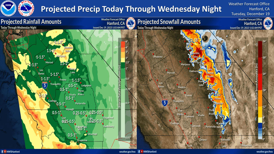
Projected Rainfall for Mariposa 1.50" to 2.00"
Projected Rainfall for Yosemite Valley: 1.00" to 1.50"
December 19, 2023 - The National Weather Service Hanford Office reports a low pressure system will impact Central California today through Wednesday night, resulting in periods of rain in the San Joaquin Valley and high elevation snow in the Sierra Nevada.
Snow levels will start at around 8,000 feet today, before dropping to about 7,000 feet Wednesday afternoon.
The majority of this precipitation will fall Wednesday afternoon and Wednesday night.
Area Forecast Discussion
National Weather Service Hanford CA
242 AM PST Tue Dec 19 2023
.SYNOPSIS...
The second in a series of atmospheric disturbances will effect
our area today and Wednesday, resulting in light rain for the San
Joaquin Valley and high elevation snow in the Sierra Nevada. There
is also a general risk for thunderstorms in the northwestern
portion of our area for today through Thursday, but severe
thunderstorms are not expected. Dry weather will return by the
weekend, along with lower temperatures.
&&
.KEY MESSAGES...
1) Winter Storm Warning issued for elevations above 8000 feet from
4 AM PST this morning to 10 AM PST Thursday morning.
2) Light, steady precipitation expected today through Thursday
with snow above 8000 feet.
3) Northwest portion of our CWA under a general thunderstorm risk
today, will move to the southwest portion by Thursday as system
moves south. Severe thunderstorms are not expected.
4) Dry weather will return by the weekend.
.DISCUSSION...
A second atmospheric disturbance brought in by a cut-off low
coming down from the northwest Pacific will bring more
precipitation to our area today and Wednesday. Light rain is
expected in the valley and foothills, and snow above 8000 feet in
the Sierra Nevada. Accompanying the snow in the mountains will be
high winds, so a Winter Storm Warning has been issued for the
Sierra Nevada above 8000 feet starting today at 4 AM and will go
through Thursday at 10 AM. Total snow accumulation of 6 to 12
inches are expected for elevations between 8000 and 9000 feet
and 1 to 2 feet of snow is expected above 9000 feet with this
system. Total rain accumulation for today through Wednesday is
expected to be 1-1.5 inches above Fresno County and 0.5-1 inches
below Fresno County, with some areas only seeing 0.25-0.5 inches,
including the desert areas and Bakersfield.
Here are the probabilities for 0.5 inches of rain for select
locations in the valley on Wednesday:
Madera: 71%
Merced: 71%
Fresno: 66%
Lemoore: 66%
Porterville: 66%
Reedley: 66%
Hanford: 61%
Bakersfield: 56%
Visalia: 56%
Delano: 51%
The SPC has the northwest portion of our CWA in a risk for general
thunderstorms today. The risk will be over the Coastal Ranges and
western valley tomorrow and Thursday. While there is the risk for
thunderstorms in those areas, no severe thunderstorms are
expected.
Lingering precipitation will hang around the mountains through
Friday, but dry weather is expected to prevail by Saturday. Medium
range models are beginning to show another atmospheric disturbance
that may bring more precipitation by mid next week.
&&
.AVIATION...
MVFR to IFR conditions are likely in and near showers until at
least Wednesday. Otherwise, VFR conditions will prevail
throughout the Central California interior over the next 24 hours.
&&
.AIR QUALITY ISSUES...
ISSUED: 12/18/2023 15:27
EXPIRES: 12/19/2023 23:59
On Tuesday December 19 2023, Unhealthy in Kern County. Unhealthy
for Sensitive Groups in Fresno, Kings, Madera, Merced, and Tulare
Counties. Fireplace/Wood Stove Burning Status is: No Burning For
All in Fresno, Kern, and Madera Counties. No Burning Unless
Registered in Kings, Merced, and Tulare Counties. Burning
Discouraged in Kern (Greater Frazier Park Area) and Sequoia
National Park and Forest.
&&
.CERTAINTY...
The level of certainty for days 1 and 2 is medium.
The level of certainty for days 3 through 7 is medium.
Certainty levels include low...medium...and high. Please visit
www.weather.gov/hnx/certainty.html for additional information
and/or to provide feedback.
&&
.HNX WATCHES/WARNINGS/ADVISORIES...
Winter Storm Warning until 10 AM PST Thursday for CAZ323-326>328-
330.
Source: NWS
