


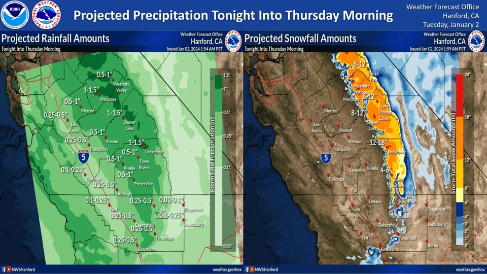
Projected Rainfall for Mariposa 1.00" to 1.50"
Projected Precipitation for Yosemite Valley: 0.50" to 1.00"
January 2, 2024 - The National Weather Service Hanford Office reports a low pressure system will impact Central California tonight into Thursday morning, resulting in rain in the San Joaquin Valley and snow in the Sierra Nevada.Snow levels will start at around 5,000 feet tonight, before dropping to about 4,000 feet Wednesday.
The majority of this precipitation will fall tonight and Wednesday morning.
Area Forecast Discussion
National Weather Service Hanford CA
310 AM PST Tue Jan 2 2024
.KEY MESSAGES...
1. A Dense Fog Advisory has been issued for the San Joaquin
Valley and Tehachapi through 11am this morning. Visibilities
could drop to below a quarter mile in some areas.
2. The first of two storm systems will bring snow and rain
Tuesday night through Thursday morning. Snow levels will start
at 5,000 and drop to 4,000. Elevations above 6,000 feet could
see 12 inches or more of snow.
3. There is a 30% chance of light snow at Tejon and Tehachapi
passes with the first storm, bringing the potential for travel
impacts.
4. The second system will begin impacting the area on Saturday
morning through Sunday night. Snow levels will be lower than the
first storm, beginning at 4,000 feet and dropping to 3,000,
again bringing potential light snow to the Tejon and Tehachapi
passes.
&&
.DISCUSSION...
Dense fog is currently occurring this morning throughout the San
Joaquin Valley and into the Tehachapi area. Visibilities at the
moment are down below a mile for a few airports across the
forecast area. Patches of a quarter mile visibility or less is
possible this morning. Additionally, at or below freezing
temperatures in the Tehachapi area could lead to patchy freezing
fog. A Dense Fog Advisory has been issued for these areas and is
valid through 11am PST this morning. This looks to be the last
night of dense fog as a storm system will begin moving through
the area late this evening.
This storm system is one of two that will impact the area this
week, and will bring rain to the San Joaquin Valley and snow to
the Sierra Nevada mountains. Rain and snow will start late
Tuesday night and continue through Thursday morning. Rain totals
will increase as you go northward of Kern County. Here are NBM
probabilities that certain cities within the forecast area will
see a quarter of an inch or more Tuesday night through Wednesday
night:
Bakersfield: 51%
Fresno: 86%
Hanford: 76%
Lemoore: 61%
Madera: 81%
Merced: 76%
Porterville: 86%
Visalia: 81%
Snow levels will lower from the last system that impacted the
area. Snow levels will start out around 5,500 feet on Tuesday
night but lower to around 4,000 feet by Thursday morning. These
snow levels are right at Kern highway passes such as Tejon and
Tehachapi, and travel along these highways may be impacted. NBM
probabilities show a 70% chance or higher of elevations above
6,000 feet receiving 12 inches of snow or more. The Tejon and
Tehachapi Pass have around a 30% chance of receiving an inch or
more.
The second of the two storms will begin to impact the area
Saturday morning through Sunday evening. While storm totals will
be lower than the first storm, snow levels will be lower as
well, starting at 4,000 feet and then lowering to around 3,000
feet by Sunday evening. This again brings the chance for snow in
the Kern county mountain passes and the potential for travel
impacts.
Additionally, there is a chance for gusty winds along the usual
wind prone areas in Kern County on Wednesday of this week. NBM
probabilities show a 60% chance or higher of 45 mph wind gusts
in the Kern county mountains. These probabilities will continue
to be monitored in the case a Wind Advisory needs to be issued.
&&
.AVIATION...
Across the San Joaquin Valley, IFR conditions possible through
19Z this morning due to dense fog. Elsewhere, mostly VFR
conditions expected until 06Z Wednesday in the Sierra Nevada,
then becoming mainly MVFR with areas of mountain obscuring IFR
in low clouds and showers.
&&
.AIR QUALITY ISSUES...
ISSUED: 01/01/2024 10:44
EXPIRES: 01/02/2024 23:59
On Tuesday January 2 2024, Unhealthy for Sensitive Groups in Kern
County. Fireplace/Wood Stove Burning Status is: No Burning For
All in Kern County. No Burning Unless Registered in Fresno, Kings,
Madera, and Tulare Counties. Burning Discouraged in Merced County,
and Kern (Greater Frazier Park Area) and Sequoia National Park and
Forest.
&&
.CERTAINTY...
The level of certainty for days 1 and 2 is medium.
The level of certainty for days 3 through 7 is medium.
Certainty levels include low...medium...and high. Please visit
www.weather.gov/hnx/certainty.html for additional information
and/or to provide feedback.
&&
.HNX WATCHES/WARNINGS/ADVISORIES...
Dense Fog Advisory until 11 AM PST this morning for CAZ301>307-
309>316-334.
Winter Weather Advisory from 10 PM this evening to 4 AM PST
Thursday for CAZ323-324-326>331.
Source: NWS
