


California and National Drought Summary for January 2, 2024
Summary
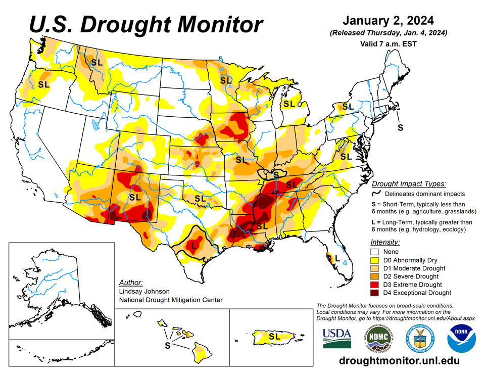
January 4, 2023 - A large storm system brought rain and snow to the Pacific and Atlantic coasts along with rain and snow in the eastern High Plains and Midwest. The Northeast remained largely unchanged from last week, with minor improvements in western New York, Pennsylvania and central Maryland where precipitation was 150% to 300% of normal. Further south along the Mid-Atlantic, 150% to 300% of normal precipitation fell, bringing improvements in Virgina, North Carolina and South Carolina. The southern part of the Southeast did not benefit from any of the precipitation that fell elsewhere along the Atlantic coast, bringing further degradations to an already very dry part of the country. The South remained the same as last week, with small areas of deterioration from northeast Texas into southwestern Arkansas, and north and central Louisiana.
A small part of southeastern Louisiana and southern Mississippi saw minor improvements. The High Plains benefited from a rain and snow weather system that moved through the area before the new year. Northeastern Colorado into eastern Nebraska had some improvement. Northern Colorado and Wyoming experienced deterioration without the benefit of the precipitation that fell further east and low snow water equivalent (SWE). The north-central Midwest had some improvements from the same storm that benefited the High Plains. Central, eastern and southern Midwest largely missed precipitation, causing deterioration in eastern Ohio, southern Indiana and Illinois, and eastern and northern Kentucky where groundwater and streamflow remain low. The West saw few improvements, except for New Mexico. Lack of precipitation and low SWE in higher elevations have left areas of Montana and Arizona worse off than last week.
Northeast
Heavy precipitation fell over the Northeast. Improvements were seen from southwest New York southward into West Virginia. The Northeast has only a few pockets of Abnormally Dry (D0), Moderate Drought (D1), and Severe Drought (D2) conditions. In New York, Long Island was lifted out of Abnormally Dry (D0) conditions. In far western New York, increased streamflows improved Severe Drought (D2) conditions to Moderate Drought (D1) conditions in Genesee and Wyoming counties. Moderate Drought (D1) conditions improved southward into Crawford County in northwestern Pennsylvania, with slightly above-normal precipitation and improving soil moisture. Good precipitation and improved streamflow brought improvement from Moderate Drought (D2) to Abnormally Dry (D0) conditions to eastern West Virginia into Maryland . These wetter conditions also lifted all Abnormally Dry (D0) conditions along the western Eastern Bay near Baltimore. Conditions along the Atlantic Coast remained status quo.
Southeast
Heavy precipitation in the Mid-Atlantic region continued the widespread improvements seen last week. The heaviest rain fell from north-central Virginia into western North Carolina and northwest South Carolina, with some areas seeing 2 to 3 inches fall — upwards of 200% of normal. One-category improvements followed this precipitation band. Georgia, which largely missed this week’s precipitation, saw areas of deterioration in the south and central areas. Abnormally Dry (D0) conditions expanded from southwestern Georgia through southern Alabama, and continued into the western Florida panhandle with little precipitation and decreasing streamflows. The remaining parts of Florida remained unchanged. Southern Alabama saw Abnormally Dry (D0) conditions introduced from southwestern Georgia and Moderate Drought (D1) extending further south, leaving 99% of Alabama in a state of Abnormal Dryness (D0) or worse.
South
Little reprieve occurred across much of the South, with only 5% of normal precipitation falling. Western and central Texas remained unchanged, with a small improvement of Moderate Drought (D1) to Abnormally Dry (D0) conditions in the Panhandle. Parts of southeast Louisiana and Mississippi had small improvements with streamflows slightly improving. This is not the case for much of the South where short- and now long-term conditions continue to decline. Streamflow and groundwater continue to counteract what precipitation is received. Eastern Texas into western Louisiana and southwestern Arkansas saw 1-category degradations for all drought categories. Central Louisiana had Extreme drought (D4) conditions expand northward into Catahoula, Winn, Richland and Concordia parishes. Moderate Drought (D1) in northwest Louisiana extended west into eastern Texas and southwestern Arkansas. Mississippi stayed largely unchanged aside from the slight reduction of Moderate Drought (D1) in the far south. Tennessee saw improvements in the east, with improving soil moisture and benefits from the precipitation experienced in the Mid-Atlantic region. Central and eastern Tennessee, on the other hand, saw Severe Drought (D2) expand northward into Kentucky. Exceptional Drought (D4) was introduced in the South at the tri-boundary with Mississippi and Alabama due to the continued lack of precipitation for the past few months.
Midwest
A weather system brought rain and snow into the Midwest, mainly in the north. Areas of central Illinois and both southeast and northeast Indiana saw improved conditions. Conditions in Minnesota, Iowa, Wisconsin and Michigan remain unchanged. Central Illinois and northeastern Indiana had improvement in Severe Drought (D2), Moderate Drought (D1), and Abnormally Dry (D0) conditions. Southern Illinois and Indiana experienced 1-category degradations matching the widespread drying trend in northern and western Kentucky. Much of Kentucky’s precipitation was 25% of normal, adding to already dry conditions spanning the past few months. Most areas of Abnormal Dryness (D0) worsened to Moderate Drought (D1). The Moderate Drought (D1) conditions in northern Kentucky and eastern Indiana increased eastward into western Ohio. Missouri remained status quo except for Moderate Drought (D1) extending over the entire southern bootheel and slight improvement near St. Louis.
High Plains
A weather system bringing rain and snow moved through the High Plains midweek last week. Central and northern states experienced up to 400% of normal precipitation. Northeastern Colorado and eastern Colorado saw improvements in Exceptional (D4), Extreme (D3), and Severe (D2) drought conditions. These improvements are a continuation of improvements seen last week. The weather system that brought improvements to much of the High Plains largely missed north-central Colorado. Conditions worsened, introducing abnormal dryness and degrading from Abnormally Dry (D0) to Moderate Drought (D1). Northern Wyoming experienced similar conditions to Montana, leading to small Abnormally Dry (D0) and Moderate Drought (D1) expansions along the northern border with Montana.
West
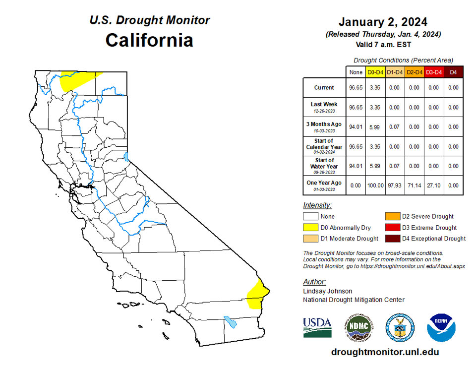
Much of the West remains status quo for the week. Precipitation fell across much of the Pacific coast from Vancouver southward into central California. Montana has not benefitted from the recent precipitation, causing small degradations along its border with Idaho, Wyoming and North Dakota. Precipitation continues to miss Arizona, mainly the north. Over the past few months Abnormal Dry (D0) conditions expanded northward into southern Utah. New Mexico did see improvements in Extreme (D3), Severe (D2) and Moderate (D1) drought conditions in the interior northwest.
Caribbean
No changes were made in Puerto Rico this week.
A high-pressure ridge inhibited precipitation across the U.S. Virgin Islands (USVI) during this U.S. Drought Monitor (USDM) week (December 27-January 2). Fragments of moisture moving in the otherwise dry northeast flow created localized showers, but rainfall amounts were mostly low. Based on data available at the time of this report, weekly rainfall totals ranged from a tenth to a third of an inch across the islands, with a couple stations on St. Thomas and St. Croix reporting half of an inch. December monthly rainfall totals ranged from about an inch on St. Croix to nearly 4 inches on St. Thomas, with St. John mostly having between 2 and 3 inches of rain. December totals were generally below normal on St. Croix and St. John but above normal on St. Thomas.
According to USGS well observations, the groundwater level on all 3 islands steadily fell this week. Depth to water on January 1: 6.14 feet on St. John, 8.21 feet on St. Thomas, and 33.23 feet on St. Croix. Satellite VHI showed a few areas of vegetative stress.
With December and year-to-date precipitation totals still well below normal, short- and long-term moderate drought (D1-SL) continued on St. Croix. December has been wet but long-term precipitation deficits remained, so long-term severe drought (D2-L) continued on St. Thomas, while St. John continued with a D-Nothing status (no drought or abnormal dryness).
Pacific
There were no changes made in Alaska this week.
There were no changes made in Hawaii this week.
The weather conditions across the U.S.-Affiliated Pacific Islands (USAPI) during this U.S. Drought Monitor (USDM) week (December 27-January 2) were similar to last week. Rain kept mostly south of Micronesia, associated with a near-equatorial trough (NET), while trade-wind disturbances (troughs, wind surge, or shear line) brought rain to parts of the region and a weakening South Pacific Convergence Zone (SPCZ) and unstable air generated showers around and over American Samoa. But for most islands in Micronesia, a dry trade-wind pattern dominated the weather. This is the dry season and fire danger is increasing as vegetation continues to dry out, especially in the Marianas.
Based on data available at the time of this report, weekly rainfall totals were mostly below the weekly minimum needed to meet most water needs, which is 1 inch in the Marianas and American Samoa and 2 inches elsewhere in Micronesia. Guam was wet with 1.98 inches of rain this week while the rest of the Marianas stations had weekly rainfall totals from a half to two-thirds of an inch. The Republic of Palau was wet. Most of the Federated States of Micronesia (FSM) were dry, with weekly precipitation totals ranging from a tenth of an inch at Pingelap to 1.23 inches at Ulithi. In the Marshall Islands, Ailinglaplap was wet with 2.53 inches of rain this week, but the other stations were dry with reports ranging from 0.26 inch at Mili to 1.95 inches at Wotje. One to four inches of rain was reported in American Samoa.
December 2023 was wet (more than the 4-inch or 8-inch monthly minimum needed to meet most water needs) across American Samoa and most of the Marianas and Palau. Most of the FSM was dry, while parts of the Marshall Islands were wet and other parts dry. December 2023 ranked as the third driest December in 73 years of data at Yap, seventh driest in 73 years at Pohnpei, fourth driest in 38 years at Pingelap, and seventh driest in 41 years at Ulithi. November-December 2023 was the third driest such 2-month period at Ulithi, fifth driest at Yap, and sixth driest at Pingelap.
Changes in the USAPI include the end of abnormal dryness at Ailinglaplap, which had a wet week, while abnormal dryness began at Pohnpei, Lukunor, Nukuoro, and Pingelap, where this week marked the third consecutive dry week (three consecutive dry weeks is a trigger for the initiation of D0-S). In addition, reports of water shortages have been received from Pohnpei, especially in places that depend on water wells. Moderate drought continued on Yap, which had its sixth consecutive dry week, and Wotje, where this week marked the seventh consecutive dry week. Severe drought continued on Ulithi, which had its ninth consecutive dry week. The rest of the reporting stations were free of drought and abnormal dryness.
Looking Ahead
During the next five days (Jan. 2-7, 2024), more heavy precipitation is expected for the central and northern Pacific coast, with some areas of higher elevation also seeing some moisture. The Gulf Coast and southern Atlantic regions are expected to see heavy precipitation. This centers around southern Louisiana, Mississippi and Alabama.
The National Weather Service Climate Prediction Center’s 6-10 day outlook (valid Jan. 3-9, 2024) favors above-normal precipitation for most of the country, with high probabilities found in the intermountain West, east of the Ohio and Mississippi River Valleys, Alaska and Hawaii. Only southern Texas is expected to have below-normal precipitation. There is an increased probability of below-normal temperatures west of the Rockies, particularly in the southwest. Following the precipitation trend, areas of probable heavy precipitation in the east also have the probability of being warmer than normal. The Northeast has the largest probability of having above-normal temperatures.
Author(s):
Lindsay Johnson, National Drought Mitigation Center
Richard Heim, NOAA/NCEI
Dryness Categories
D0 Abnormally Dry—used for areas showing dryness but not yet in drought, or for areas recovering from drought.
Drought Intensity Categories
D1 Moderate Drought
D2 Severe Drought
D3 Extreme Drought
D4 Exceptional Drought
Drought or Dryness Types
S Short-term, typically less than 6 months (agriculture, grasslands)
L Long-term, typically more than 6 months (hydrology, ecology)
SL Area contains both short- and long-term impacts
Source: National Drought Mitigation Center
