


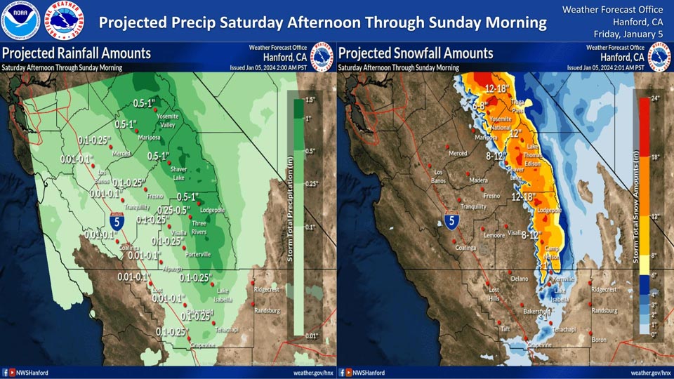
Mariposa and Yosemite Valley projected precipitation: 0.50" - 1.00".
January 5, 2024 - National Weather Service Hanford Office officials report a relatively cold storm system will impact Central California Saturday afternoon through Sunday morning, resulting in low elevation snow in the Sierra Nevada, adjacent foothills, and Kern County mountains, as well as periods of rain in the San Joaquin Valley.
The snow level will start at around 4,000 feet Saturday afternoon, before dropping to about 2,000 feet Sunday morning.
The majority of this precipitation will fall Saturday night.
Area Forecast Discussion
National Weather Service Hanford CA
204 AM PST Fri Jan 5 2024
&&
.KEY MESSAGES...
1. A colder storm system with 10 inches or more of snow in the
Sierra Nevada at elevations above 4,000 feet will impact the
area Saturday through Sunday morning.
2. Snow levels with this system will drop to around 2,500 feet,
resulting in the possibility of hazardous travel over the Kern
County mountain passes Saturday evening through Sunday morning.
3. Westerly wind gusts near 55 mph in the Mojave Desert Slopes
Saturday and Sunday.
4. High probability (80-100%) of freezing temperatures across
rural parts of the San Joaquin Valley Monday and Tuesday
mornings.
&&
.DISCUSSION...
As the trough that brought rain to the area a couple days ago
has moved out of the area, a ridge has set up and is providing a
couple days of stable weather before we head into the next storm
system coming in. The storm system coming in will be colder than
the previous one, and looks to impact the area Saturday morning
through Sunday morning. Much of the snow is anticipated to fall
Saturday morning through Saturday night. Snow levels will begin
at 4,000 feet and drop to around 2,500 feet by Sunday morning.
High wind gusts will lead to blowing snow and decreased
visibilities, making travel very difficult to impossible - as
such, a Winter Storm Warning has been issued for the Sierra
Nevada above 4,000 feet from 10am Saturday through 10am Sunday.
Currently, areas above 4,000 feet have a 45% chance or greater
of seeing 8 inches of snow or more. Here are specific
probabilities that certain Sierra Nevada locations will see 8
inches of snow or more through Sunday morning:
Tioga Pass: 69%
Yosemite Valley: 46%
Badger Pass Ski Area: 80%
Wawona: 46%
Huntington Lake: 86%
Shaver Lake: 52%
Lodgepole: 93%
Grant Grove: 82%
Elevations above 6,000 feet have a 35% chance or higher of
seeing 12 or more inches of snow. Those areas include:
Badger Pass Ski Area: 49%
Lodgepole: 71%
Huntington Lake: 56%
Grant Grove: 35%
Localized amounts of 18 inches or more are possible for areas
above 8,000 feet elevation. Additionally, since snow levels get
down to 2,500 feet, there is a 30% chance or higher for some
areas in and near the Kern County mountain passes to see an inch
or less of snow. This has the potential to impact nightly
commutes on Saturday and morning commutes on Sunday. A Winter
Weather Advisory is in effect for the Kern County mountains from
10pm Saturday through 10am Sunday. Here are probabilities that
areas in and near the Kern County mountain passes will see an
inch of snow:
I-5 along the Grapevine: 12%
Tehachapi: 30%
Frazier Park: 34%
Pine Mountain Club: 40%
Wind prone areas of the Kern County mountains and desert will
see high gusts as the system moves through. Chances of 55 mph
gusts or higher are possible, and a Wind Advisory for the Mojave
Desert Slopes from 4pm Saturday through 1pm Sunday has been
issued.
Additionally, as the system moves away, cold air will follow it
and bring low temperatures in the San Joaquin Valley down below
32 degrees. NBM probabilities show an 80-100% chance of seeing
32 or less as a low temperature for these cities: Fresno,
Hanford, Lemoore, Madera, Merced, Porterville, and Visalia.
&&
.AVIATION...
Fog and mist starts to creep in at 09Z lowering conditions to MVFR
to IFR with patches of LIFR conditions and could last through 19Z.
Otherwise, MVFR to VFR conditions will prevail throughout the
Central California Interior over the next 24 hours.
&&
.AIR QUALITY ISSUES...
ISSUED: 01/04/2024 15:27
EXPIRES: 01/05/2024 23:59
On Friday January 5 2024, Fireplace/Wood Stove Burning Status is:
Burning Discouraged in Fresno, Kern, Kings, Madera, Merced, and
Tulare Counties, and Kern (Greater Frazier Park Area) and Sequoia
National Park and Forest.
&&
.CERTAINTY...
The level of certainty for days 1 and 2 is medium.
The level of certainty for days 3 through 7 is medium.
Certainty levels include low...medium...and high. Please visit
www.weather.gov/hnx/certainty.html for additional information
and/or to provide feedback.
&&
.HNX WATCHES/WARNINGS/ADVISORIES...
Wind Advisory from 4 PM Saturday to 1 PM PST Sunday for CAZ338.
Winter Storm Warning from 10 AM Saturday to 10 AM PST Sunday
for CAZ323>331.
Winter Weather Advisory from 10 PM Saturday to 10 AM PST
Sunday for CAZ333>336.
Source: NWS
