


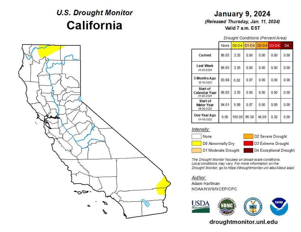
California and National Drought Summary for January 9, 2024
Summary
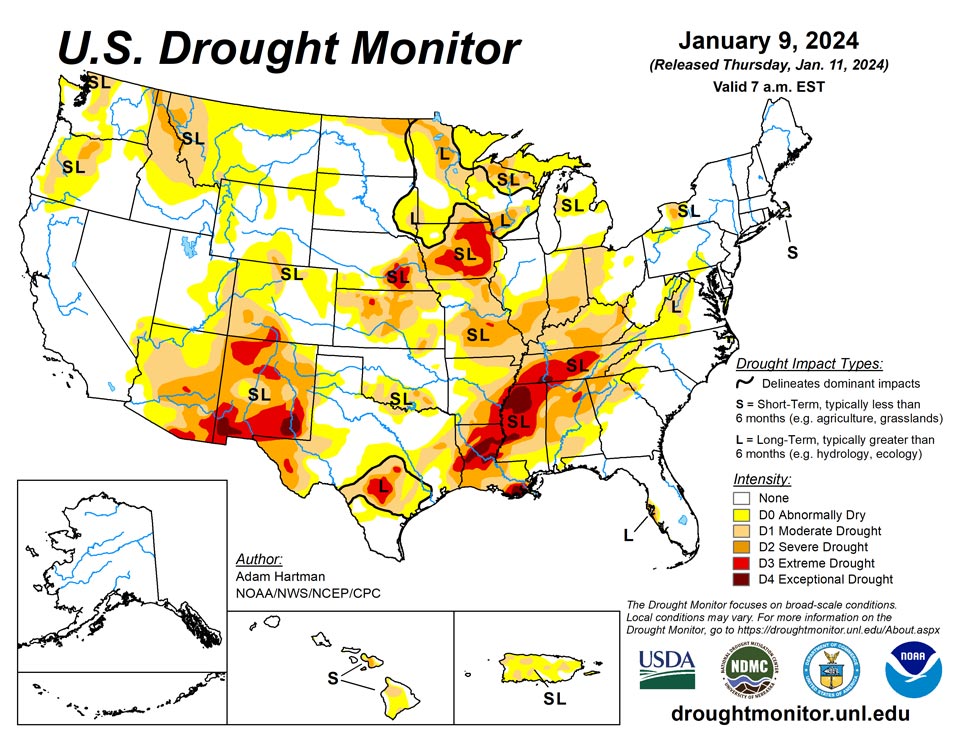
January 11, 2024 - It was a stormy week across much of the eastern lower 48 states leading to widespread drought improvements east of the Rockies. A winter storm pummeled the Mid-Atlantic and Northeast over the weekend (January 6-7). Then a second system in its wake was ramping up across the Mississippi Valley toward the end of this week (Tuesday, January 9), bringing heavy rainfall to the Lower Mississippi and the Deep South. More than 2 inches of rain fell in many areas, with localized amounts upwards of 5 inches. Heavy snow also fell across parts of the Central Plains and Midwest as it moved slowly eastward, with snowfall still ongoing across parts of the Midwest and Great Lakes by the end of this week. Across the Intermountain West, it was a wet and snowy week mainly for parts of the Pacific Northwest and isolated locations in the Great Basin and Four Corners region, leading to some targeted improvements. However, several areas experiencing antecedent dryness and drought missed out on the precipitation, leading to further degradations, particularly across the northern Rockies, Front Range, and across parts of the western Colorado Plateau in Arizona. In Alaska, no changes to the drought depiction are warranted this week. In Hawaii, a Kona low spinning off to the north brought heavy bands of precipitation to western portions of the island chain, warranting some improvements to drought conditions. Conversely, another week of warm temperatures and below normal rainfall in Puerto Rico resulted in widespread deterioration of the drought depiction.
Northeast
A strong storm system moving up the Eastern Seaboard January 6-7 brought heavy rainfall to coastal areas of the Northeast this week, with heavy snow falling in portions of the interior. Some locations away from the coast picked up a foot or more of snowfall. However, most of the precipitation fell in drought-free areas. The exception was across the valley and ridge region in the central Appalachians extending from southern Pennsylvania to West Virginia, where targeted improvements were made in areas that have been bombarded by several episodes of heavy rainfall over the past couple of months.
Southeast
Short- and long-term drought conditions improved this week throughout the Southeast, associated with the passage of two storm systems. 1-category improvements were broadly warranted from the central Gulf Coast northward to the southern and central Appalachians, where many locations received over 2 inches of rainfall this week. However, despite the heavy rainfall, long-term deficits remain very much in place, especially across upstate portions of Alabama and Georgia, where several locations are still experiencing more than 8-inch rainfall deficits over the past 6 months. Drought also improved across western portions of the Florida Peninsula, but areas right along the coastline near the Tampa Bay area still have over 20-inch rainfall deficits over the past year, so much more is needed to ease drought in the areas immediately adjacent to the coast.
South
Much needed rain fell this week across much of the South, with many locations across the Lower Mississippi and Tennessee Valleys picking up well over 2 inches of rainfall. However, long-term drought conditions still very much remain in place across much of the Lower Mississippi Valley, with several areas across Louisiana and Mississippi experiencing upwards of 20-inch rainfall deficits over the past year. There are marked improvements in the upper layers of the soils and in some of the short-term drought indices in recent weeks, as the storm track has been active across the Gulf Coast states. However, more rainfall will be needed to dig into the long-term precipitation deficits and recharge groundwater. Improvements to drought conditions are also warranted across parts of the Southern Plains this week, where widespread precipitation totals in excess of 1 inch were received.
Midwest
A powerful winter storm was ongoing and slowly moving eastward across the Mississippi Valley leading up to the end of this week, January 9. Enough precipitation fell across much of the region this week to warrant no changes after several areas, especially along the Ohio and Middle Mississippi Valleys, have experienced several rounds of drought deterioration over at least the past month. However, targeted improvements are warranted across parts of Missouri and Illinois, where hydrologic conditions have rebounded and short-term indicators are improving. In addition, heavy snow fell across parts of the Corn Belt, with liquid-equivalent amounts in excess of 1 inch across much of northern Missouri, parts of southern Iowa, and northern Illinois. Conversely, despite above normal precipitation, a re-evaluation of the drought indicators suggested the depiction was underdone across the Bootheel of Missouri extending into northern Arkansas. Therefore, conditions are degraded to D1 (moderate drought) in those locations this week.
High Plains
Storminess in recent weeks has resulted in widespread improvements across the Central Plains. Additional improvements were again warranted this week in the Central Plains, where a couple of storm systems brought wintry precipitation, with weekly snowfall totals of over 5 inches for many areas (locally more than 10 inches), further increasing short-term precipitation surpluses. Unfortunately, the storm track has predominantly been displaced southward across the southern half of the U.S. over the past couple of months, which has led to slow deterioration of drought conditions across portions of the western High Plains and along the Front Range of the Rockies. With another week of below normal precipitation, degradation was again warranted this week. Seasonal snowfall remains below average for many locations and daytime temperatures have been running above normal (and above freezing), exposing soils to evaporation, predominantly from high winds.
West
Targeted improvements are warranted across parts of the Pacific Northwest and New Mexico, where 7-day precipitation totals, in combination with storminess in recent weeks, have improved some of the long-term drought indicators, even improving seasonal snowpack to be closer to normal for several locations. However, some degradation was also warranted in locations that missed out on heavier precipitation amounts this week, and who have experienced below normal precipitation and above normal temperatures over the past few months. Seasonal snowpack is running below normal throughout much of the Intermountain West, although interior portions of the Great Basin are faring a little better. So much of the recent improvements can be attributed to rainfall and improving soil moisture and stream flows.
Caribbean
Another week of above normal temperatures and below normal precipitation during what is already a dry time of the year resulted in a widespread 1-category degradation of conditions across Puerto Rico. Stream flows are running well below normal throughout the island, as rainfall deficits continue to climb (upwards of 10-inch deficits over the past 6 months).
Early in the drought week (Wed, Jan 3 – Tue, Jan 9), a cold front and associated surface low moved out over the western Atlantic, weakening the trades. As the front stalled and weakened, patchy fragments of moisture and associated showers moved south across the Islands, though for the most part a mix of sun and clouds prevailed this week. SPoRT IMERG satellite-based Quantitative Precipitation Estimates (QPE) for the past 7-days show the USVI region was rather dry, generally receiving well under a half-inch of rain.
Rainfall amounts peaked at 0.36-inch (station VI-SC-25, Christiansted 4.4 W) for the drought week across the island of St. Croix. Lesser amounts included 0.31-inch of rain at VI-SC-23 (Christiansted 6.5 W), 0.28-inch at VI-SC-30 (Christiansted 1.7 SW), 0.20-inch at VI-SC-34 (Frederiksted 1.9 NE) and at East Hill, 0.19-inch at VI-SC-10 (Christiansted 1.6 E), 0.12-inch at VI-SC-20 (Frederiksted 1.7 ESE), 0.10-inch at the Henry Rohlsen Airport, and 0.07-inch at VI-SC-35 (Frederiksted 1.3 ENE). Groundwater level at the Adventure 28 Well changed very little during the period, hovering near 33.20 feet, before rapidly rising at the end of the period to 32.90 feet (data is provisional). No adjustments to the current D1(SL) depiction at St. Croix were deemed necessary this week.
No adjustments were made to the drought depiction at St. John this week. Station VI-SJ-5 (Cruz Bay 1.6 E) measured only 0.05-inch of rain during the week, and station VI-SJ-3 (Windswept Beach) noted only 0.02-inch of precipitation. The water level at the Susannaberg DPW 3 Well fell from 6.30 feet (midnight Jan 3) to 6.96 feet (noon Jan 9). Saint John continues to enjoy drought/dryness-free conditions.
On the island of St. Thomas, station VI-ST-13 (Charlotte Amalie 1.2 NNW) measured 0.24-inch of rain this week. Very meager rainfall amounts (up to 0.02-inch of rain) were noted at VI-ST-15 (Charlotte Amalie West 1.3 N), VI-ST-14 (Nadir 0.3E/Tropical Marine), the Cyril King Airport, VI-ST-5 (Charlotte Amalie West 4.2 WNW), and VI-ST-1 (Anna’s Retreat 2.5 ESE). The Grade School 3 Well water level fell dramatically (provisional data) from 8.42 feet (midnight Jan 3) to 10.62 feet (noon Jan 9). It is unclear at this time why there was such a pronounced drop in wellwater level this week. No changes were made to St. Thomas’ current depiction of D2(L).
Pacific
Given antecedent conditions, decent snowpack leading up to this week, and the time of year, no changes are warranted in Alaska. Alaska remains drought-free.
An area of low pressure (known as a Kona low) brought heavy rainfall to portions of the western Hawaiian Islands toward the end of this week, leading to 1-category improvements to the drought depiction in Honolulu, Molokai, and Lanai.
Relatively dry conditions dominated most of the USAPI region during the past drought week (Wed, Jan 3 – Tue, Jan 9, 2024). Several passing showers were noted in places, associated with weak trade-wind troughs, and areas of enhanced trade convergence. Several trade wind surges (associated with southward intrusions and/or strengthening of the subtropical ridge) were noted during the period, resulting in increased wind speeds and wave heights across portions of the USAPI. Incidentally, the only station this week to meet minimum water requirements is Kapingamarangi in the southern Federated States of Micronesia (FSM, 2.14 inches of rain with 1 day missing). A broad band of heavy precipitation (2-4+ inches) remained just south of nearly all the USAPI region this week, with the exception of Kapingamarangi at 1 deg N latitude. South of the equator, a surface trough brought numerous showers and isolated thunderstorms to American Samoa and offshore waters.
During the past 7-days (through 12z Jan 9), SPoRT IMERG satellite-based quantitative precipitation estimates (QPE) were well under a half-inch of rain across the Republic of the Marshall Islands (RMI). For the FSM and the Commonwealth of the Northern Mariana Islands (CNMI), QPE values ranged from near zero rainfall to about an inch, and near one-inch for the Republic of Palau. South of the equator, satellite-based rainfall estimates ran as high as 2-4 inches during the past week, though these higher totals apparently missed ground reporting stations.
Historical records show that during the second-half of a major warm event (El Nino), much of the USAPI region may be subjected to widespread and intense drought. Although each El Nino event is unique, and we are only in January, it would be prudent to carefully monitor the possibility of significant drought in the weeks and months ahead. It is also advisable to have a plan in place early to address the possibility of serious water shortages down the road.
Over the South Pacific, the three main reporting locations on American Samoa received up to 0.70-inch of rain this past drought week. Pago Pago measured a quarter of an inch this week. The precipitation accumulations for the last three months include a whopping 25.00 inches in December, 3.69 inches in November, and 8.54 inches in October. Across the higher terrain, Siufaga and Toa Ridges reported 0.67-inch and 0.69-inch of rain (respectively) this week. The island of Tutuila maintains dryness/drought-free conditions at this time.
The RMI reported very little precipitation during the past week, with Kwajalein having the greatest total (0.19-inch). Ailinglaplap, Jaluit, Mili, and Wotje did not measure any rainfall this period. At Ailinglaplap, nine of the last 11 months were wet (i.e. met the minimum water requirement of 8 inches). Eleven of the last 11 months were wet at Mili, and 8 of the past 11 months were wet at Majuro. Majuro measured only 0.07-inch of rain this week. Most of the RMI remains dryness/drought-free, with the exception of Wotje (D1(S)). Lack of data precluded any analysis at Utirik.
Across the FSM, precipitation amounts ranged from 0.04-inch at Rumung (3 days missing) to 2.14 inches at Kapingamarangi (1 day missing). The latter station has been wet for 9 of the past 11 months. Intermediate precipitation amounts include 0.21-inch at Pohnpei (1 day missing, 10 of the last 11 months have been wet), and 0.28-inch at Ulithi. Their respective drought designations remain at D0(S) and D2(S). Nukuoro has been wet for the last 11 consecutive months, and received 0.32-inch of rain this past week with 1 day missing. Nukuoro continues at D0(S). Just over four-tenths of an inch of rain was measured at Woleai, and 0.56-inch of rain (3 days missing) was noted at Chuuk. Ten of the past 11 months have been wet at Chuuk, and both Chuuk and Woleai persist with no dryness or drought. Lukunoch received 0.57-inch of precipitation (3 days missing), and its drought designation remains at D0(S). North Fanif, Kosrae, Pingelap, and Yap measured 0.77-inch, 0.78-inch, 0.84-inch, and 1.07 inches of rain this past week, respectively, with each station except for Yap missing one day of data. Ten of the last 11 months were wet in Kosrae, and no dryness/drought continues for the island. The designations for Pingelap and Yap remain at D0(S) and D1(S) this week, respectively. No analysis was possible at Fananu due to lack of data.
Rainfall totals across the CNMI ranged from 0.31-inch at Guam to 0.90-inch at Saipan (ASOS). Other precipitation amounts across the Marianas include 0.44-inch at Rota, 0.45-inch at Dededo (1 day missing), a half-inch at Agat (1 day missing), 0.63-inch at Saipan (IAP, manual gauge, 2 days missing), and 0.89-inch at Tinian. Eight of the last 11 months were wet in Saipan, 10 of the last 11 were wet in Rota, and 11 of the last 11 months were wet in Guam. The CNMI remains free of dryness and drought.
The Republic of Palau remains dryness and drought free this week. Airai (Palau IAP) and the Koror COOP both received just under an inch of rain (0.96-inch and 0.97-inch, respectively). One day of rainfall data was missing at the Koror COOP, and nine of the past 11 months were wet.
Looking Ahead
During the next five days (January 11-15), a storm system is forecast to develop and intensify east of the Rockies, bringing potentially heavy rain and snow to parts of the eastern U.S. In the wake of this storm system bitterly cold temperatures are forecast to spill southward from Canada, leading to dangerously cold temperatures and wind chills across portions of the central and northern U.S.
The Climate Prediction Center’s 6-10 day outlook (valid January 16-20), favors enhanced chances of below normal temperatures across much of the lower 48 states, with the highest chances (greater the 90%) centered over the Middle Mississippi Valley. Conversely, above normal temperatures are favored in the southwest U.S., underneath a mid-level ridge of high pressure that is forecast. Below normal precipitation is favored across many areas east of the Rockies during the next 6-10 days, as dry air moves in behind a departing storm system. However, a frontal boundary is forecast to remain draped across the Gulf of Mexico, bringing increased above normal precipitation chances to southern Texas and the Florida Peninsula. Above normal precipitation is also favored across parts of the West Coast, northern Rockies, and northern High Plains, associated with moist southwesterly flow into the northwestern U.S.
Author(s):
Adam Hartman, NOAA/NWS/NCEP/CPC
Anthony Artusa, NOAA/NWS/NCEP/CPC
Dryness Categories
D0 Abnormally Dry—used for areas showing dryness but not yet in drought, or for areas recovering from drought.
Drought Intensity Categories
D1 Moderate Drought
D2 Severe Drought
D3 Extreme Drought
D4 Exceptional Drought
Drought or Dryness Types
S Short-term, typically less than 6 months (agriculture, grasslands)
L Long-term, typically more than 6 months (hydrology, ecology)
SL Area contains both short- and long-term impacts
Source: National Drought Mitigation Center
