


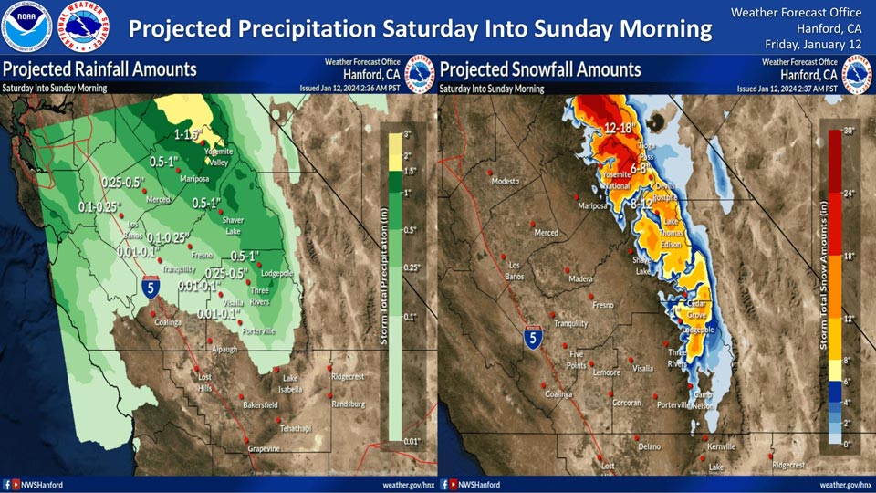
Projected rainfall for Mariposa: 0.50" to 1.00"
Projected rainfall for Yosemite Valley: 1.00" to 1.50"
January 12, 2024 - National Weather Service Hanford Office officials report a storm system will impact Central California Saturday into Sunday morning, resulting in snow in the Sierra Nevada and periods of rain in the San Joaquin Valley, north of Kern County.
The snow level will start at around 6,000 feet Saturday morning, before rising to about 7,000 feet Saturday afternoon.
The majority of this precipitation will fall Saturday evening and Saturday night.
Area Forecast Discussion
National Weather Service Hanford CA
115 AM PST Fri Jan 12 2024
.KEY MESSAGES...
1. Sub-freezing temperatures across the San Joaquin Valley this
morning and possibly tonight into Saturday morning.
2. A warmer storm system will impact the Sierra Nevada on Saturday
through early Sunday morning, resulting in mountain snow above 5,000
feet and lower elevation rainfall.
3. A warming trend will set up starting early next week, with
afternoon temperatures approaching 5 to 10 degrees above normal by
Thursday.
4. The combination of this week's rainfall and an upper level ridge
aloft results in overnight and early morning fog becoming possible
again next week.
&&
.DISCUSSION...
Latest model ensembles have a northerly flow this morning over our
area with a negative tilted trough from the Pacific Northwest to the
Rockies and a weak ridge off the coast of California. This flow is
helping bring clear skies and below freezing temperatures this
morning. Latest probabilities show a 50 to 75 percent chance of lows
this morning at or below 28 degrees in the rural areas. In Fresno
and Bakersfield, there is a 55 and 35 percent chance respectively of
this morning's low temperatures at or below 32 degrees.
Model ensembles show a trough sliding in starting Saturday through
Sunday bringing some rain and snow. Latest probabilities have at
least a 50 percent chance of 12 inches or more of snow around
Yosemite above 6,500 feet resulting in a Winter Storm Warning being
issued for the Yosemite area. A Winter Weather Advisory has been
issued for the Sierra Nevada south of Yosemite as there is a 40 to
80 percent chance of 8 inches or more of snow above 8,000 feet. Down
in the Valley, there is a 45 to 80 percent chance of at least a
tenth of an inch of rain in Visalia and Hanford and points north
with probabilities decreasing south down to 11 percent in
Bakersfield.
After the trough slides out on a Sunday, a strong ridge of high
pressure develops over the entire west coast and strengthens
throughout the week. This ridge will help bring warmer
temperatures and stable air conditions to the San Joaquin
Valley. The stability with the ridge in combination with the
rain from the weekend storm brings the possibility of morning
tule fog to develop. Temperatures will increase to about 5 to 10
degrees above average by next Thursday. However, no record high
temperatures will be threatened until at least Thursday.
Here are the probabilities of at least a tenth of an inch of rain
from 10 am Saturday, January 13, 2024 to 10 am Sunday, January 14,
2024:
Fresno-61%
Bakersfield-11%
Lemoore-36%
Merced-81%
Reedley-66%
Delano-26%
Hanford-46%
Madera-66%
Porterville-36%
Visalia-61%
Here are the probabilities of snow from 4 AM Friday, January 12,
2024 to 4 AM Monday, January 15, 2024:
Probability of 6 inches or more of snow above 5,500 feet:
Tioga Pass: 96%
Yosemite Valley: 17%
Badger Pass: 80%
Wawona: 6%
Huntington Lake: 49%
Shaver Lake: 0%
Lodgepole: 2%
Grant Grove: 0%
&&
.AVIATION...
Some localized areas of MVFR conditions in mist are possible
before 18Z. Otherwise, VFR conditions will prevail for the next
24 hours.
&&
.AIR QUALITY ISSUES...
ISSUED: 01/11/2024 14:32
EXPIRES: 01/12/2024 23:59
On Friday January 12 2024, Fireplace/Wood Stove Burning Status is:
No Burning Unless Registered in Fresno, Kern, and Madera Counties.
Burning Discouraged in Kings, Merced, and Tulare Counties, and
Kern (Greater Frazier Park Area) and Sequoia National Park and
Forest.
&&
.CERTAINTY...
The level of certainty for days 1 and 2 is high.
The level of certainty for days 3 through 7 is medium.
Certainty levels include low...medium...and high. Please visit
www.weather.gov/hnx/certainty.html for additional information
and/or to provide feedback.
&&
.HNX WATCHES/WARNINGS/ADVISORIES...
Freeze Warning until 8 AM PST this morning for CAZ301>303-
305>307-309>312-314>316.
Freeze Watch from late tonight through Saturday morning for
CAZ301>303-305>307-309>312-314>316.
Winter Storm Warning from 10 PM this evening to 10 AM PST
Sunday for CAZ323-324-326.
Winter Weather Advisory from 10 PM this evening to 10 AM PST
Sunday for CAZ327>331.
Source: NWS
