


California and National Drought Summary for January 23, 2024
Summary
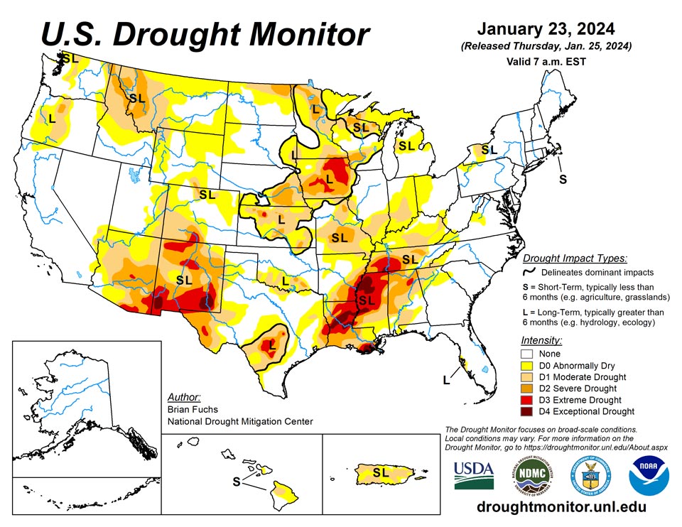
January 25, 2024 - The current period was dry over most of the country with the greatest amount of precipitation occurring along the west coast and from east Texas into Arkansas. Temperatures were well below normal for most locations east of the Rocky Mountains, where departures were 5 degrees or more below normal for most areas. The greatest departures from normal were over Tennessee, Kentucky, and northern portions of Alabama and Mississippi where readings were 20-25 degrees below normal. The warm winter continued in the West with temperatures 5-10 degrees above normal over a majority of the region. The warmer-than-normal temperatures have been a challenge for snow accumulation with many locations, especially in the northern Rockies, having a very challenging start to the snow accumulation season. With an active pattern through the central Plains into the Midwest the past few weeks, a reassessment of drought indicators was done in many locations this week to examine drought intensity levels and adjust where the data supported it. In most instances, drought remains but the data allowed for intensities to be reduced. The end of the period had an active pattern again developing in the southern Plains and into the South where widespread precipitation was anticipated after the data cutoff for this week. These locations will be assessed on next week’s map.
Northeast
Temperatures were below normal for all of the region outside of northern Maine, with the greatest departures over Pennsylvania, Maryland and West Virginia where departures were 12-15 degrees below normal. Even though this week was dry for the region, the recent wetter pattern has not changed conditions much at all, especially with the cooler temperatures. Drought still remains over western New York and in the coastal areas of Massachusetts where hydrological impacts remain. There were no changes to the drought depiction for this week for this region.
Southeast
A dry week for the region outside of some isolated showers in southern and eastern Florida. Temperatures were below normal for all areas outside of south Florida, and the greatest departures were over Tennessee with areas up to 25 degrees below normal for the week. Earlier this week, portions of northern Alabama still had ice remaining on the landscape and some discussions took place that this was the biggest cold outbreak since the mid-1990s. A reassessment of conditions over Virgina allowed for some reduction of abnormally dry conditions. Moderate drought was eliminated from South Carolina and into northeastern Georgia based on the last several weeks. Much of eastern Tennessee had continued improvement to the drought status, with more improvements made this week with a full category improvement in the east as well as some reduction of extreme drought in the west. A few pockets in northern and southwestern Alabama had abnormally dry and moderate drought improved this week as well.
South
Cooler-than-normal conditions dominated the region with departures of 10-15 degrees below normal common in the region. The greatest rains took place in east Texas to southwest Arkansas and into southeast Oklahoma. These rains continued past the data cutoff period and everything from Tuesday morning forward will be assessed on the next map. The rains allowed for some improvements, with a full category change over much of east Texas and improvements to moderate drought over central and northern Arkansas as well as the far northwest corner of Louisiana and southeast Oklahoma.
Midwest
Temperatures were below normal over the entire region this week with the greatest departures over Kentucky, where temperatures were 16-20 degrees below normal. There was some isolated precipitation over Missouri, southern Illinois, southern Iowa and northern Minnesota. A reassessment of the data over western and southern Iowa allowed for some improvement to the extreme and severe drought in these areas. It was reported that insulation from the snow has kept soils thawed in some areas, and moisture infiltration is being observed in soils. The last pocket of extreme drought was removed in southern Missouri along with improvements to severe drought here. Moderate drought was reduced in northwest and east central Missouri as the recent wetter pattern has allowed a shift in the physical indicators.
High Plains
It was a mostly dry week over much of the region with only eastern Kansas receiving widespread, albeit light, precipitation. Temperatures were below normal for all areas outside the plains of Colorado and Wyoming and northern North Dakota where they were 3-6 degrees above normal. Outside of these areas, temperatures were generally 9-15 degrees below normal for the week. The wetter pattern over the last several months allowed for a reassessment of the data to investigate potential changes in the drought intensity levels. It was noted that even though the last 9-12 months have a stronger signal toward the wet spectrum, there are still long-term issues that go out 24-36 months or more in much of the central Plains. In looking at the data, support for the existing extreme drought in eastern Nebraska was not there, so it was improved to severe drought this week. In Kansas, areas of moderate and severe drought were also improved based on the lagging support for these intensity levels. Degradation took place over portions of northern North Dakota and eastern Wyoming where abnormally dry conditions were expanded based on the short-term dryness in these regions.
West
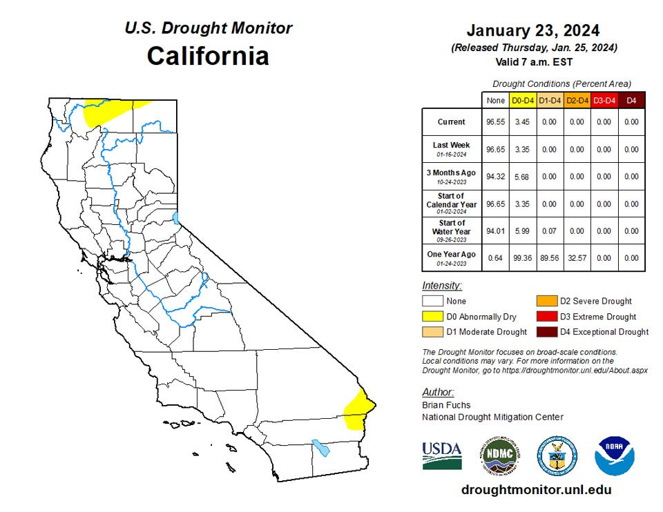
Above-normal temperatures dominated much of the region with departures of 9-12 degrees above normal over portions of western Wyoming, northern Nevada, central Idaho and northeast Utah. Temperatures were cooler than normal over Washington, northern Oregon, northern Idaho and much of Montana. The greatest rains were along the coast with some flooding issues being reported this week, especially in southern California. Further inland, it remained dry and the dryness coupled with the warmer temperatures has allowed for snow drought to develop, especially in the northern Rocky Mountains. The wetter pattern over the most recent weeks allowed for a reassessment of conditions over New Mexico and into eastern Arizona, where improvements were made. Areas of extreme and exceptional drought were reduced this week in western New Mexico while severe drought was improved in western New Mexico into eastern Arizona. Moderate drought was expanded over western Wyoming and severe drought was expanded over western Montana. Oregon had moderate and severe drought improvements in the west while moderate drought expanded in the central portion of the state. Washington saw moderate drought improved along the northwest coast and western portions of the state with abnormally dry conditions expanding in the north central.
Caribbean
Puerto Rico had widespread degradation over the northern and southern portions of the islands. Fires as well as groundwater levels have continued to be a problem.
Recent weather has grown drier on St. John, where rainfall at Windswept Beach totaled only 0.14 inches, which increased the one- and two-month deficits there. In tandem with the dry weather, groundwater levels have steadily dropped over the last week. Given these factors, short-term abnormal dryness has redeveloped there. On St. Thomas, rain reports from this week topped out at 0.32 inches. Groundwater levels dropped this week and were similar to levels from two weeks ago, prolonging severe long-term drought. On St. Croix, short-term rainfall deficits were in the abnormally dry to moderate drought range, groundwater levels remained close to the same and short- and long-term moderate drought continued.
Pacific
There were no changes in Alaska this week.
In Hawaii, conditions continued to improve on Maui with even more flooding reported this week. Moderate drought was removed from west Maui and abnormally dry conditions improved on western areas of Maui and on Kahoolawe. On the Big Island, abnormally dry conditions spread over the northeast part of the island and moderate drought slightly improved in the northwest.
Rainfall on Palau totaled 1.55 at Airai and 1.15 inches at the Koror cooperative observing site, and Palau remained free of drought or abnormal dryness.
American Samoa remained free of drought or abnormal dryness this week as heavy rain fell in multiple locations. Siufaga Ridge received 4.73 inches of rain, Toa Ridge received 5.91 inches of rain, and Pago Pago received 7.49 inches of rain.
Short-term abnormal dryness continued this week across the Mariana Islands. Rainfall on Saipan totaled 0.49 inches. In Guam, rain totaled 1.04 inches at the primary climate monitoring station; CoCoRaHs observations ranged between 0.69 and 0.98 inches. Given recent dry weather there, short-term abnormal dryness continued for another week, though conditions have likely improved some with this week’s rain. Short-term abnormal dryness also continued on Rota this week, where rain totaled 0.62 inches.
Short-term abnormal dryness continued in Kwajalein this week, where 1.36 inches of rain were reported, marking the fifth consecutive week with less than 2 inches of rain. After a couple very dry weeks, a deluge of 7.34 inches of rain fell in Ailinglaplap, and they remained free of drought or abnormal dryness. After 3 of the last 4 weeks had been completely dry, 2.79 inches of rain were reported on Jaluit this week. While this likely helped conditions some, short-term abnormal dryness continued for another week. No data were reported for Utirik, so no Drought Monitor depiction was made. Short-term moderate drought continued on Wotje, where 0.36 inches of rain were recorded this week, marking the tenth consecutive week with less than 2 inches of rain. Short-term moderate drought developed on Majuro, which recorded 0.42 inches of rain this week, marking the fifth consecutive week with less than an inch of rain.
Through January 23, this January has been the driest in 70 years of record-keeping there. Short-term abnormal dryness continued this week on Mili, where 1.78 inches of rain fell. While this marked the fifth consecutive week with less than 2 inches of rainfall, conditions likely improved a bit compared to the previous four weeks, two of which were completely dry.
Severe short-term drought continued on Yap and Ulithi this week. Yap reported 0.66 inches of rain, marking another rather dry week there, while Ulithi reported 0.62 inches. Short-term abnormal dryness continued on Woleai, where 1.61 inches of rain were reported. No data were reported for Fananu, so no Drought Monitor depiction was made there. Near the end of the period, rainfall totals increased to 7.12 inches on Chuuk, and abnormal dryness there was removed. Short-term abnormal dryness continued this week on Lukunor, where 2.96 inches of rain was reported. Conditions likely improved some this week, though the five previous weeks all fell below two inches of rain. Short-term abnormal dryness improved to normal conditions on Nukuoro, where over 10 inches of rain fell this week. Kapingamarangi reported 2.09 inches of rain this week, and they remained free of drought or abnormal dryness. Short-term moderate drought continued on Pohnpei, though 5.04 inches of rain were reported this week.
January rainfall, while significantly higher than last week, is still well below normal to date. Continued heavier rains there would likely improve the situation. Short-term abnormal dryness continued on Pingelap, where 2.63 inches of rain fell this week. Short-term abnormal dryness was removed from Kosrae after 11.23 inches of rain fell this week.
Looking Ahead
Over the next 5-7 days, the active pattern over the South and Southeast will continue, with much of the region anticipating 3-5 inches of precipitation. The coastal areas of the Pacific Northwest also will remain active with the next system coming ashore. Dry conditions are expected over the central and northern Plains, northern Rocky Mountains and Southwest. Temperatures will flip back to a warmer-than-normal pattern for most of the country, with greatest departures above normal over the northern Plains and upper Midwest.
The 6–10 day outlooks show a high probability of warmer-than-normal temperatures over much of the U.S. during this period with the highest probabilities over the Plains and Upper Midwest. There is a high probability of below-normal temperatures over Alaska and much of Florida. The precipitation outlook has the highest probability of below-normal precipitation over much of the eastern third of the U.S. with the greatest chances over the Ohio River valley. There are above-normal chances of above-normal precipitation over much of the West and into the Plains during this time.
Author(s):
Brian Fuchs, National Drought Mitigation Center
Curtis Riganti, National Drought Mitigation Center
Dryness Categories
D0 Abnormally Dry—used for areas showing dryness but not yet in drought, or for areas recovering from drought.
Drought Intensity Categories
D1 Moderate Drought
D2 Severe Drought
D3 Extreme Drought
D4 Exceptional Drought
Drought or Dryness Types
S Short-term, typically less than 6 months (agriculture, grasslands)
L Long-term, typically more than 6 months (hydrology, ecology)
SL Area contains both short- and long-term impacts
Source: National Drought Mitigation Center
