


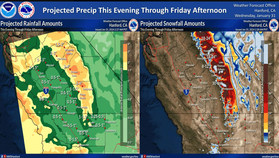
Projected Precipitation for Mariposa 2.00" to 3.00"
Projected Precipitation for Yosemite Valley: 1.50" to 2.00"
January 31, 2024 - The National Weather Service Hanford Office officials report an impactful atmospheric river will bring heavy precipitation to Central California Wednesday evening through Friday afternoon.
The majority of this precipitation will fall Wednesday night and Thursday morning.
The snow level will start at around 6,000 feet Wednesday evening, before dropping to about 5,000 feet Thursday evening.
Excessive rainfall in the Sierra Nevada below 5,000 feet and adjacent foothills may cause flooding and mudslides.
Area Forecast Discussion
National Weather Service Hanford CA
122 AM PST Wed Jan 31 2024
.KEY MESSAGES...
1. Damaging south winds gusts are expected along the Interstate
5 corridor through the Grapevine today and tonight. Strong,
gusty south winds are anticipated in the Coastal Range and San
Joaquin Valley today and tonight.
2. Major to extreme winter storm impacts in the Sierra Nevada
above 5,000 feet this evening through Thursday evening due to
snow amounts up to four feet.
3. Excessive rainfall in the Sierra Nevada below 5,000 feet and
adjacent foothills may cause flooding and mudslides this evening
through Thursday afternoon.
4. A few strong thunderstorms are possible in most of Central
California Thursday afternoon and Thursday evening.
&&
.DISCUSSION...
An impactful atmospheric river will approach Central California
today. As a result, the surface pressure gradient should
increase significantly. South wind gusts near 65 mph are
expected along the Interstate 5 corridor through the Grapevine
from 9 AM PST this morning until 4 AM PST Thursday morning. A
High Wind Warning is in effect. South wind gusts near 45 mph
are expected in the Coastal Range and San Joaquin Valley from 9
AM PST this morning until 4 AM PST Thursday morning. A Wind
Advisory is in effect.
Precipitation assoicated with the aforementioned atmospheric
river will overspread Central California from west to east this
evening. Major to extreme winter storm impacts are expected in
the Sierra Nevada above 5,000 feet this evening through
Thursday evening due to snow amounts up to four feet. Here are
probabilities of 18 inches or snow or more for select locations
in the Sierra Nevada from 10 PM PST this evening until 4 PM PST
Friday afternoon:
Badger Pass Ski Area - 93%
Lodgepole - 90%
Huntington Lake - 89%
Wishon Lake - 86%
Tuolumne Meadows - 67%
Tioga Pass - 58%
The heaviest rainfall associated with the atmospheric river is
expected tonight through Thursday afternoon. Flooding and
mudslides are possible in the Sierra Nevada below 5,000 feet and
adjacent foothills due to rain amounts up to three inches. A
few strong thunderstorms are conceivable in much of Central
California Thursday afternoon and Thursday evening. Here are
probabilities of one inch or more of rain for select locations
in the San Joaquin Valley from 10 PM PST this evening until 4 PM
PST Friday afternoon:
Merced - 83%
Clovis - 75%
Madera - 71%
Fresno - 68%
Porterville - 67%
Visalia - 62%
Tulare - 56%
Hanford - 49%
Bakersfield - 35%
There should be a brief break in precipitation Friday night and
Saturday, before another atmospheric river impacts Central
California late this weekend into early next week.
&&
.AVIATION...
VFR conditions will prevail this morning and this afternoon.
MVFR or lower conditions are likely in and near precipitation
this evening and tonight.
&&
.AIR QUALITY ISSUES...
On Wednesday, January 31st, 2024, fireplace/wood stove burning
status is: no burning for all in Kern and Kings Counties. No
burning unless registered in Fresno and Madera Counties. Burning
discouraged in Merced and Tulare Counties, as well as in Kern
(Greater Frazier Park Area) and Sequoia National Park and
Forest.
&&
.CERTAINTY...
The level of certainty for days 1 and 2 is medium.
The level of certainty for days 3 through 7 is medium.
Certainty levels include low, medium, and high. Please visit
www.weather.gov/hnx/certainty.html for additional information
and/or to provide feedback.
&&
.HNX WATCHES/WARNINGS/ADVISORIES...
Wind Advisory from 9 AM this morning to 4 AM PST Thursday for
CAZ300>316.
Winter Storm Warning above 5000 feet from 10 PM this evening
to 4 PM PST Friday for CAZ323-326>331.
Winter Storm Warning above 5000 feet from 4 AM Thursday to 4
PM PST Friday for CAZ333-334-336.
High Wind Warning from 9 AM this morning to 4 AM PST Thursday
for CAZ334>336.
Source: NWS
