


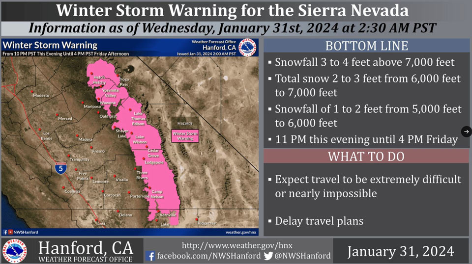
January 31, 2024 - The National Weather Service Hanford Office officials report a Winter Storm Warning has been issued for the Sierra Nevada above 5,000 feet from 10:00 P.M. Wednesday evening until 4:00 P.M. Friday afternoon.
The majority of this snow will fall Wednesday night and Thursday morning.
Winds may gust as high as 55 mph on exposed ridgetops and along the crest.
Travel will be extremely difficult or nearly impossible. As a result, travel is not advised.
Winter Storm Warning
URGENT - WINTER WEATHER MESSAGE
National Weather Service Hanford CA
841 AM PST Wed Jan 31 2024

CAZ323-326>331-010100-
/O.CON.KHNX.WS.W.0005.240201T0600Z-240203T0000Z/
Yosemite NP outside of the valley-Upper San Joaquin River-
Kaiser to Rodgers Ridge-Kings Canyon NP-Grant Grove Area-
Sequoia NP-South End of the Upper Sierra-
Including the cities of Tuolumne Meadows, Wawona,
Devils Postpile, Florence Lake, Lake Thomas Edison, Lake Wishon,
Huntington Lake, Shaver Lake, Cedar Grove, Grant Grove,
Hume Lake, Giant Forest, Lodgepole, and Johnsondale
841 AM PST Wed Jan 31 2024

...WINTER STORM WARNING REMAINS IN EFFECT FROM 10 PM THIS EVENING
TO 4 PM PST FRIDAY ABOVE 5000 FEET...

* WHAT...Heavy snow expected above 5,000 feet. Snowfall 3 to 4
  feet above 7,000 feet. Total snow accumulations 2 to 3 feet
  from 6,000 feet to 7,000 feet. Snowfall 1 to 2 feet from 5,000
  feet to 6,000 feet. Wind will gust as high as 55 mph on
  exposed ridgetops and along the crest.

* WHERE...The Sierra Nevada above 5,000 feet.

* WHEN...Valid from 10 PM PST Wednesday evening until 4 PM PST
  Friday afternoon.

* IMPACTS...Travel will be extremely difficult or nearly
  impossible. Gusty winds could bring down tree branches.

PRECAUTIONARY/PREPAREDNESS ACTIONS...

If you must travel, keep an extra flashlight, food, and water in
your vehicle in case of an emergency.

The latest road conditions for the state you are calling from can
be obtained by calling 5 1 1.
Source: NWS
