


California and National Drought Summary for January 30, 2024
Summary
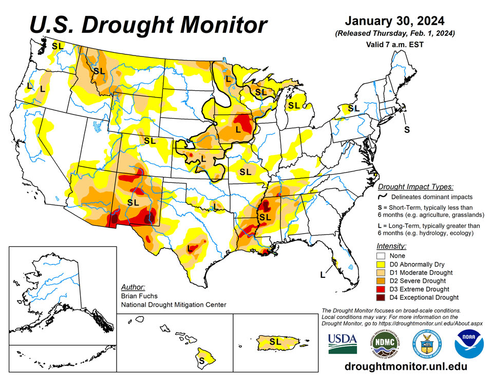
February 1, 2024 - The synoptic pattern over the last week favored continued precipitation over the coastal areas of the Pacific Northwest and very widespread and heavy precipitation in the South and Southeast and into the Midwest. Some areas of east Texas, Louisiana and Mississippi recorded over 8 inches of rain for the week. Dryness dominated the central to high Plains and most of the rest of the West as well as the Atlantic Coast into south Florida. After a very strong cold snap in previous weeks, temperatures this week were warmer than normal over much of the U.S., with the upper Midwest having the greatest departures of 15-20 degrees above normal in Minnesota and northern Wisconsin. Across the plains of Wyoming and Montana and into the northern Rocky Mountains, there is building concern over the lack of snow this current water year and snow drought concerns are also prevalent in portions of the High Plains and upper Midwest.
Northeast
Temperatures in the region were warmer than normal this week with departures of 6-12 degrees above normal widespread. Precipitation was recorded over much of the region with areas from western Pennsylvania through New York recording over 200% of normal for the week. Portions of the Maryland and Delaware coasts were dry as well as much of Maine. Improvements were made this week to the moderate drought and abnormally dry conditions over western New York and northwest Pennsylvania. Abnormally dry conditions were also improved in northern and western Virginia and far western West Virginia.
Southeast
A wet week for most all areas outside of the Florida peninsula and southern Georgia to the coastal areas of the Carolinas. The greatest precipitation was recorded in portions of Alabama and Mississippi with over 400% of normal for the week. Temperatures were warmer than normal for the entire region with departures of 6-12 degrees common. The widespread and ample precipitation allowed for some easing of drought conditions in the region. Most all drought areas saw a full category improvement this week and no degradation was noted. Some abnormally dry conditions were expanded in the coastal plains of North Carolina where short-term dryness is developing.
South
Temperatures were cooler than normal over central Oklahoma into northern Texas where departures were 1-3 degrees below normal. Most of the rest of the region was near normal to 3-6 degrees above normal, with the greatest departures over Mississippi where it was 9-12 degrees above normal. A very wet week for the region. Some areas of east Texas and into Arkansas recorded over 800% of normal precipitation for the week and almost all areas were 200-400% of normal precipitation. Widespread improvements to the overall drought status were made this week over most of Arkansas, Tennessee, Mississippi, Louisiana and east Texas where a full category improvement in drought intensity status was made. Some areas were investigated for multiple categories of improvement but with some of the long-term issues still showing up, most improvements were limited to a single reduction in intensity this week. Southern Oklahoma and north Texas had targeted improvements to the severe and moderate drought as well as the abnormally dry conditions. Portions of west Texas continued to be dry and may need to see drought intensification if the pattern doesn’t change.
Midwest
Temperatures were warmer than normal over most of the region outside of Missouri where they were closer to normal for the week. Northern Minnesota into northern Wisconsin recorded temperatures that were 18-24 degrees above normal this week. Outside of western Iowa, Minnesota, northern Wisconsin and northern Michigan, almost all areas saw 200-400% of normal precipitation for the week. Many reports were coming in that in areas where snow insulated the ground during the previous cold outbreak, soils were actually not frozen and moisture was making its way into the soil profile. There was also less runoff associated with melting this week than there would have been if the soils were frozen. Most drought areas saw a full category of improvement this week in Missouri, Illinois, Indiana and Kentucky. Abnormally dry conditions were improved in Ohio while extreme and severe drought were improved in portions of central and southern Iowa. In Michigan, abnormally dry conditions were expanded over the northern portions of the Lower Peninsula while moderate drought was added to the Upper Peninsula.
High Plains
Most of the region was dry this week, with only portions of central Colorado, far southwest Kansas, and northern North Dakota recording normal to above-normal precipitation. Temperatures were near normal over much of Kansas and central Nebraska and were 5-10 degrees above normal for most of the rest of the region. Most of the region did not see any changes to the drought status this week. Moderate drought was introduced over portions of western South Dakota and central Wyoming due to the ongoing dry winter and lack of snow. Abnormally dry conditions were improved in central Colorado based on the short-term improvements being observed there.
West
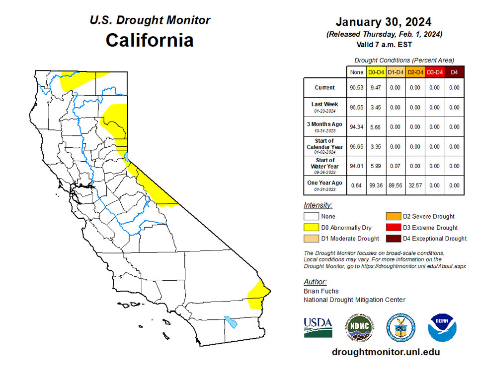
Areas along the coast and inland and into the Southwest recorded above-normal precipitation this week while much of the central to northern Rocky Mountains were dry. The entire West was near to above normal for temperatures with the greatest departures over Montana, Wyoming, Utah and Idaho, where some areas were 10-15 degrees above normal for the week. This same area has been impacted by snow drought this current water year and there are developing concerns about water availability heading into the spring and summer as we approach February. Severe drought was introduced into more of southern and central Montana and into northwest Wyoming. Abnormally dry conditions were expanded in southern Utah and introduced into eastern California and western Nevada. Moderate drought expanded in northeast Oregon into Idaho and in southern Oregon in the Klamath Valley. Elsewhere in Oregon and Washington, improvements were made to moderate and severe drought in western Oregon and Washington while some areas of abnormally dry conditions were contracted. Areas of southern Arizona and southern New Mexico had improvements where extreme drought was removed from much of southern Arizona and reduced in southern New Mexico with additional improvements to moderate and severe drought.
Caribbean
There were no changes in Puerto Rico this week.
Short-term abnormal dryness continued this week on St. John, where rainfall amounts of 0.45 and 0.63 inches of rain were reported. Groundwater levels continued a gradual decline on St. John this week. Short- and long-term moderate drought continued on St. Croix, where groundwater levels fluctuated and rain amounts ranged from 0.68 to 1.01 inches. On St. Thomas, severe long-term drought continued, as rain amounts of 0.36 and 0.46 inches were reported and groundwater levels remained mostly the same, with only a slight increase being recorded compared to last week.
Pacific
There were no changes in Alaska this week.
In Hawaii, conditions continued to improve on Maui with a favorable local response to the recent wet pattern. Moderate drought was removed from Maui and abnormally dry conditions improved in areas of Maui and Kahoolawe. On the Big Island, moderate drought conditions were improved slightly along the northwest Kona coast.
Compared to the last few weeks, the weather on American Samoa was on the drier side this week, though neither abnormal dryness nor drought is present. Rainfall at Toa Ridge totaled 0.65 inches, while Siufaga Ridge recorded 0.95 inches and Pago Pago received 1.77 inches.
Palau remained free of abnormal dryness or drought this week with high rainfall amounts. Koror received 6.31 inches of rain this week, while Airai recorded 7.48 inches.
Short-term abnormal dryness continued at Rota, Saipan, and Guam this week, though conditions varied across Saipan. Rainfall measurements on Saipan were only 0.12 and 0.35 inches, though local reports were that vegetation was green, except for some hints of stress on the northern end of the island. Rainfall measurements on Guam this week ranged from 0.16 to 0.65 inches. On Rota, 0.87 inches of rain were reported this week.
Short-term severe drought continued this week on Yap and Ulithi, where rain totaled 1.25 and 2.4 inches. While conditions have likely improved some on Ulithi, this will be re-evaluated next week since the rain likely fell near the end of the period. Short-term abnormal dryness continued on Woleai, though with 2.35 inches of rain, conditions have probably improved there. No data were reported for Fananu, so no Drought Monitor depiction was made there. On Chuuk, 0.55 inches of rain were reported this week; however, with over 7 inches last week, there was no drought or abnormal dryness. Short-term abnormal dryness continued this week on Lukunor, where rain amounts totaled only 0.04 inches (though a couple days were missing from the record). Nukuoro received 0.79 inches of rain, though this followed 10.5 inches of rain last week, so they remained free of drought or abnormal dryness. Kapingamarangi remained free of drought or abnormal dryness after 1.57 inches of rain fell there this week. Short-term moderate drought continued on Pohnpei this week, where 0.79 inches of rain were reported (with a couple days missing) after a wet previous week. Short-term abnormal dryness continued this week on Pingelap, where 0.5 inches of rain were reported, marking the sixth week out of the last seven with less than an inch of rain. On Kosrae, following 11.65 inches of rain last week, only 0.13 inches have been reported this week (though with three days missing), and conditions remained free of drought or abnormal dryness.
Short-term abnormal dryness continued this week on Kwajalein, where no rain was reported. Ailinglapalap remained free of drought or abnormal dryness after 7.34 inches of rain fell last week; with one day missing, no rain had been reported this week. Short-term abnormal dryness continued on Jaluit, though conditions there have likely improved some, as heavy rains late in the period increased the weekly rainfall total to 3.57 inches. No data were reported for Utirik, so no Drought Monitor depiction was made there. Short-term moderate drought continued on Wotje this week, where only 0.05 inches of rain were reported (with one day missing). Short-term moderate drought continued on Majuro as well, though heavy rains fell near the end of the period and raising weekly rain totals to 3.52 inches, likely improving the situation there. Short-term moderate drought continued on Mili, where only 0.07 inches of rain were reported (with one day missing).
Looking Ahead
Over the next 5-7 days, an active pattern is anticipated to remain over the South and Southeast with another week of widespread precipitation from east Texas to the Carolinas. Some precipitation is anticipated over the central Plains while a wetter pattern is anticipated over most of the West, with the greatest precipitation along the California coast. Temperatures during this period are anticipated to be below normal over California, Nevada, and into Utah and Arizona while warmer-than-normal temperatures are expected to impact the Plains, Midwest and portions of the South. The greatest departures of above-normal temperatures are anticipated in the upper Midwest and northern Plains with departures of 20-25 degrees above normal.
The 6–10 day outlooks show above-normal chances for warmer-than-normal temperatures over much of the country east of the Rocky Mountains with the greatest probability over the Great Lakes region and upper Midwest. The best chances for cooler-than-normal temperatures will be over the West and Florida with the best chances of below-normal temperatures over much of California. Much of the western half of the U.S. will have high probabilities of above-normal precipitation with the greatest chances over the Southwest. The best chances of below-normal precipitation will be in upper New England and through much of the Mid-Atlantic and into the Southeast. The highest probability of below-normal precipitation will be over Maine, New Hampshire and Massachusetts.
Author(s):
Brian Fuchs, National Drought Mitigation Center
Curtis Riganti, National Drought Mitigation Center
Dryness Categories
D0 Abnormally Dry—used for areas showing dryness but not yet in drought, or for areas recovering from drought.
Drought Intensity Categories
D1 Moderate Drought
D2 Severe Drought
D3 Extreme Drought
D4 Exceptional Drought
Drought or Dryness Types
S Short-term, typically less than 6 months (agriculture, grasslands)
L Long-term, typically more than 6 months (hydrology, ecology)
SL Area contains both short- and long-term impacts
Source: National Drought Mitigation Center
