


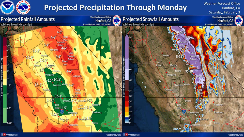
Projected Precipitation for Mariposa: 3.00" to 4.00"
Projected Precipitation for Yosemite Valley: 4.00" to 6.00"
February 3, 2024 - National Weather Service Hanford Office officials post projected precipitation totals for the upcoming storm that will end late Monday night into early Tuesday morning.
Area Forecast Discussion
National Weather Service Hanford CA
355 AM PST Sat Feb 3 2024
.KEY MESSAGES...
1. Extreme winter storm impacts in the Sierra nevada above 5,000
feet Saturday night through Sunday night due to snow load and
snow amounts up to six feet.
2. Excessive rainfall in the Sierra Nevada below 5,000 feet and
adjacent foothills Saturday night through Sunday night may cause
flash flooding.
3. Heavy rainfall in the San Joaquin Valley Saturday night
through Sunday night may result in flooding of creeks, streams,
and low-lying areas.
4. Strong to damaging southeast to south wind gusts are possible
Sunday and Sunday night.
&&
.DISCUSSION...
Convective showers and thunderstorms popped-ups again across
the San Joaquin Valley Friday afternoon. While the air-mass over
Central California had less instability to work with, a few
thunderstorms did manage to develop over the San Joaquin Valley
Friday afternoon. In addition, the cold front associated with
the mid-week atmospheric river (AR) event continues to influence
winds across the Mojave Desert. Current observations show
several locations still gusting up to 50 mph. During the next
few hours, will continue to see more locations drop below
criteria as winds diminish even further this Saturday. As one AR
exits, another AR is aiming and ready to strike California
later this weekend.
After two days of afternoon thunderstorm activity, the air-mass
over Central California has become more stable as we begin our
transition to wet weather from another AR. Ensembles show a much
more stable atmosphere over the region as the area gets one
quiet day before conditions become more unsettled on Sunday.
Furthermore, the midweek disturbance moves further away as
Desert winds continue to diminish. Again, quiet conditions will
prevail ahead of a major storm to hit the area. High-Res
ensemble surface wind analysis agrees very well with the current
timing of strong wind product expiration.
A Winter Storm Watch is in effect for the next AR event
expected to strike California this evening. Currently, leading
edge of the AR plume is some 300 plus miles west of the Southern
California Coast and moving toward the state. Satellite derived
rain rates show areas of of 1 to 2 inches per hour with
isolated 3 inches just behind the leading edge. From a stand-
point of Cluster (upper air) and Integrated Vapor Transport
(IVT-moisture) analysis, this will be a significant storm. Snow
Warnings and flooding products will remain posted as heavy
precipitation moves in. Ensembles holding steady with the timing
of precipitation onset between 4 PM PST and 7 PM PST this
evening. Ensemble probability of exceedance of reaching one half
of an inch of rain are listed below for the AR:
Heres the 4.1 NBM probabilities of 0.50 inches of rain falling on
Saturday-Sunday, the 3th-4th, at select locations in the valley:
Merced: 96% | Madera: 91% | Reedley: 81% | Fresno: 81%
Hanford: 71% | Lemoore: 61% | Porterville: 61% | Visalia: 66%
Delano: 46% | Bakersfield: 61% |
Longer range analysis show the disturbance remaining over the
West Coast through the middle of next week. Ensemble Cluster
Analysis does not have the axis of the disturbance east of the
area until next Wednesday. Therefore, unsettled conditions may
persist for several days before clearing begins over the West
Coast.
&&
.AVIATION...
Areas of MVFR conditions as a slight chance of showers continue
this morning. MVFR will continue after 00Z Sunday with
increasing chances of lowering to IFR as heavy rain and snow
move into the area. The lower conditions will exist through at
least 12Z Sunday.
&&
.AIR QUALITY ISSUES...
On Saturday February 3 2024, Fireplace/Wood Stove Burning
Status is: Burning Discouraged in Fresno, Kern, Kings, Madera,
Merced, and Tulare Counties, and Kern (Greater Frazier Park
Area) and Sequoia National Park and Forest.
&&
.CERTAINTY...
The level of certainty for days 1 and 2 is high.
The level of certainty for days 3 through 7 is medium.
Certainty levels include low...medium...and high. Please visit
www.weather.gov/hnx/certainty.html for additional information
and/or to provide feedback.
&&
.HNX WATCHES/WARNINGS/ADVISORIES...
Wind Advisory until 7 AM PST this morning for CAZ338.
Flood Watch from this evening through late Monday night for
CAZ300>322-324-325-332-337>339.
Wind Advisory from 10 PM this evening to 10 PM PST Sunday for
CAZ300>322.
Winter Storm Watch above 5000 feet from this evening through
late Monday night for CAZ323-326>331.
Winter Storm Watch above 6000 feet from this evening through
late Monday night for CAZ333-334-336.
&&
Source: NWS
