


Includes Mariposa-Madera Foothills and Yosemite Valley
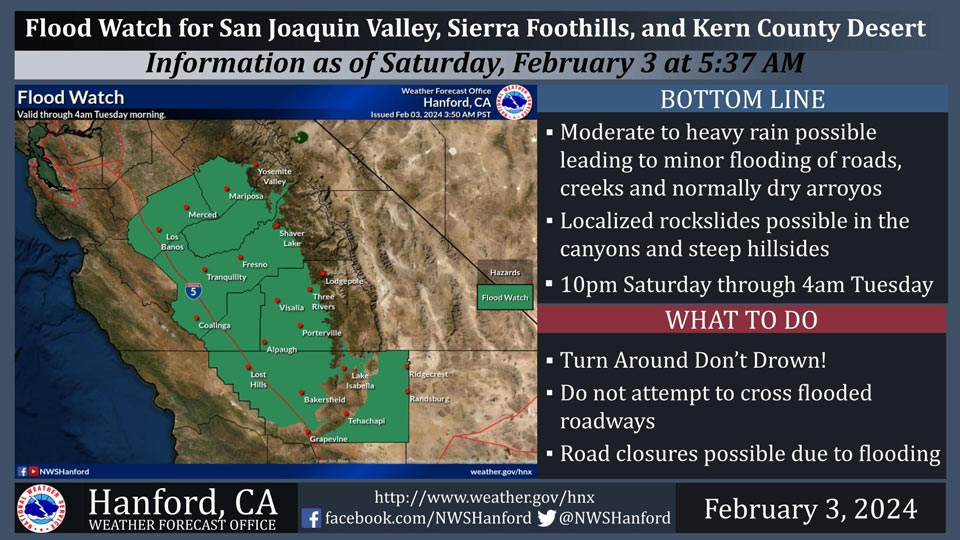
February 3, 2024 - National Weather Service Hanford Office officials report moderate to heavy rain is possible in the Sierra Nevada, Sierra Foothills, and the Kern County Desert.
This could lead to minor flooding of roads, creeks, and normally dry arroyos. Additionally, localized rockslides are possible in the canyons and steep hillsides.
This Flood Watch is valid through 4:00 A.M. Tuesday morning.
Flood Watch
Flood Watch
National Weather Service Hanford CA
740 AM PST Sat Feb 3 2024

West Side Mountains north of 198-Los Banos - Dos Palos-Merced -
Madera - Mendota-Planada - Le Grand - Snelling-Coalinga - Avenal-
West Side of Fresno and Kings Counties-Caruthers - San Joaquin -
Selma-Fresno-Clovis-West Side Mountains South of 198-Buttonwillow
- Lost Hills - I5-Delano-Wasco-Shafter-Hanford - Corcoran -
Lemoore-Visalia - Porterville - Reedley-Buena Vista-Bakersfield-
Southeast San Joaquin Valley-South End San Joaquin Valley-
Mariposa Madera Foothills-Mariposa-Madera Lower Sierra-Fresno-
Tulare Foothills-Fresno-Tulare Lower Sierra-South End Sierra
Foothills-South End of the Lower Sierra-Yosemite Valley-San
Joaquin River Canyon-Kern River Valley-Indian Wells Valley-Mojave
Desert Slopes-Mojave Desert-
Including the cities of Los Banos, Le Grand, Planada, Mojave,
Avenal, Bakersfield, Lemoore, Kettleman City, Visalia, Rosamond,
Coalinga, Randsburg, Porterville, Ridgecrest, Alpaugh, Parlier,
Bass Lake, Lamont, Five Points, Kingsburg, Buttonwillow, Tulare,
Delano, Atwater, Edwards AFB, Taft, Mariposa, Kernville, North
Fork, Hanford, Selma, Fish Camp, Kerman, Merced, Shafter,
Millerton Lake, Arvin, Inyokern, Yosemite Valley, Coarsegold,
Lost Hills, McKittrick, Lake Isabella, Corcoran, Richgrove,
Oakhurst, Wasco, Fresno, Goshen, El Portal, Blackwells Corner,
California City, Lemoore Station, Auberry, San Luis Reservoir,
Madera, Lake Mcclure, Sanger, and Camp Nelson
740 AM PST Sat Feb 3 2024

...FLOOD WATCH REMAINS IN EFFECT FROM THIS EVENING THROUGH LATE
MONDAY NIGHT...

* WHAT...Flooding caused by excessive rainfall continues to be
  possible.

* WHERE...A portion of central California, including the following
  areas, Bakersfield, Buena Vista, Buttonwillow - Lost Hills - I5,
  Caruthers - San Joaquin - Selma, Coalinga - Avenal,
  Delano-Wasco-Shafter, Fresno-Clovis, Fresno-Tulare Foothills,
  Fresno-Tulare Lower Sierra, Hanford - Corcoran - Lemoore, Indian
  Wells Valley, Kern River Valley, Los Banos - Dos Palos, Mariposa
  Madera Foothills, Mariposa-Madera Lower Sierra, Merced - Madera -
  Mendota, Mojave Desert, Mojave Desert Slopes, Planada - Le Grand -
  Snelling, San Joaquin River Canyon, South End San Joaquin Valley,
  South End Sierra Foothills, South End of the Lower Sierra,
  Southeast San Joaquin Valley, Visalia - Porterville - Reedley,
  West Side Mountains South of 198, West Side Mountains north of
  198, West Side of Fresno and Kings Counties and Yosemite Valley.

* WHEN...From this evening through late Monday night.

* IMPACTS...Excessive rainfall may result in flooding of low-lying
  and flood-prone locations. Flooding may occur in poor drainage and
  urban areas. Storm drains and ditches may become clogged with
  debris. Mud and rock slides will be possible.

* ADDITIONAL DETAILS...
  - Heaviest rain is expected Sunday through Sunday night.
  - Heaviest rainfall is expected on Monday through Monday night.
    http://www.weather.gov/safety/flood

PRECAUTIONARY/PREPAREDNESS ACTIONS...

You should monitor later forecasts and be alert for possible Flood
Warnings. Those living in areas prone to flooding should be prepared
to take action should flooding develop.
Source: NWS 