


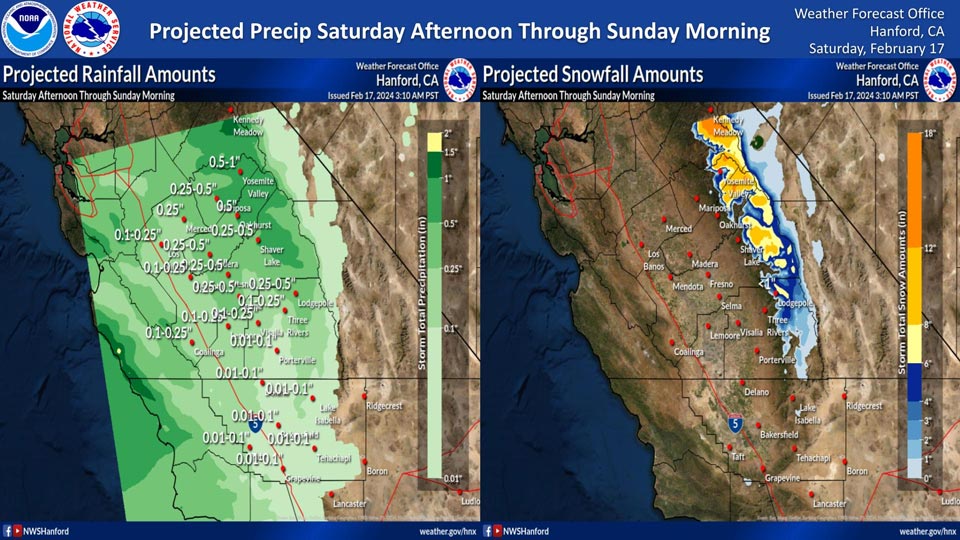
Mariposa projected rainfall: 0.25" - 0.50"
Yosemite Valley projected rainfall: 0.50" - 1.00"
February 17, 2024 - National Weather Service Hanford Office officials report a relatively weak storm system will impact Central California Saturday afternoon through Sunday morning, resulting in periods of precipitation.
The majority of this precipitation will fall Saturday evening.
Snow levels associated with this system are projected around 6,000 feet.
Area Forecast Discussion
National Weather Service Hanford CA
1240 AM PST Sat Feb 17 2024
.KEY MESSAGES...
1. An atmospheric river will impact Central California Sunday
evening through Monday evening.
2. Excessive runoff from heavy rainfall north of Kern County
Sunday evening through Monday evening may cause mudslides and
rockslides in steep canyons and hillsides, as well as flooding
of low-lying areas.
3. Major winter storm impacts are expected in the Sierra Nevada
above 6,000 feet Sunday evening through Monday evening due to
snow amounts up to four feet.
4. A few strong thunderstorms are possible north of Kern County
Monday afternoon into Monday evening.
&&
.DISCUSSION...
The High Resolution Ensemble Forecast system indicates moderate
probabilities (40 to 50 percent) of dense fog developing south
of Fresno County this morning. As always, satellite data and
surface observations will be monitored closely and a Dense Fog
Advisory will be issued, if needed. A trough of low pressure
will approach the coast of California today. Precipitation
ahead of this trough of low pressure will begin to overspread
Central California this afternoon. The trough of low pressure
will pass across the service area tonight. A Winter Weather
Advisory is in effect for the Sierra Nevada above 6,000 feet
this afternoon through Sunday morning due to snow amounts up to
eight inches. Rain amounts in the San Joaquin Valley this
afternoon through Sunday morning should generally be less than
one quarter of an inch.
There should be a brief break in precipitation from late Sunday
morning into Sunday afternoon, before an atmospheric river
moves over Central California Sunday evening through Monday
evening. Strong, gusty southeast to south winds are possible
Sunday afternoon and Sunday evening in the northern portion of
the San Joaquin Valley. A Wind Advisory may be required. Major
winter storm impacts are anticipated in the Sierra Nevada above
6,000 feet Sunday evening through Monday evening due to snow
amounts up to four feet. Heavy rainfall may result in flooding
of streams and creeks Sunday evening through Monday evening.
Bear Creek at McKee Road in Merced County is forecast to reach
monitor stage Monday afternoon. Excessive runoff from heavy
rainfall may cause mudslides and rockslides in the Sierra Nevada
below 6,000 feet and adjacent foothills Sunday evening through
Monday evening. Here are probabilities of two inches of rain or
more for select locations in the Sierra Nevada and adjacent
foothills Sunday evening through Monday evening:
Wawona - 88%
Fish Camp - 88%
Yosemite Valley - 85%
Bass Lake - 83%
Mariposa - 82%
El Portal - 80%
Dinkey Creek - 78%
Shaver Lake - 77%
Oakhurst - 72%
Auberry - 68%
A few strong thunderstorms are possible north of Kern County
Monday afternoon into Monday evening. A localized risk for a
brief tornado and/or wind damage is conceivable. Periods of
precipitation will linger in Central California Monday night
through Tuesday night. Precipitation will finally come to an end
Wednesday as a trough of low pressure moves east of the service
area. A ridge of high pressure will build over the Golden State
Thursday and Friday, resulting in the return of dry weather.
&&
.AVIATION...
MVFR visiblities are conceivable south of Fresno County this
morning due to mist. MVFR or lower conditions are possible this
afternoon through Sunday morning in and near any precipitation.
&&
.AIR QUALITY ISSUES...
On Saturday, February 17th, 2024, fireplace/wood stove burning
status is: no burning unless registered in Fresno County.
Burning discouraged in Kern, Kings, Madera, Merced, and Tulare
Counties, as well as in Kern (Greater Frazier Park Area) and
Sequoia National Park and Forest.
&&
.CERTAINTY...
The level of certainty for days 1 and 2 is high.
The level of certainty for days 3 through 7 is medium.
Certainty levels include low, medium, and high. Please visit
www.weather.gov/hnx/certainty.html for additional information
and/or to provide feedback.
&&
.HNX WATCHES/WARNINGS/ADVISORIES...
Flood Watch from Sunday afternoon through Wednesday morning
for CAZ300>312-315-317>322-324-325.
Winter Weather Advisory above 6000 feet from 10 AM Saturday to
10 AM PST Sunday for CAZ323-325>330.
Winter Storm Warning above 6000 feet from 4 PM Sunday to 4 AM
PST Wednesday for CAZ323-326>331-333.
Source: NWS
