


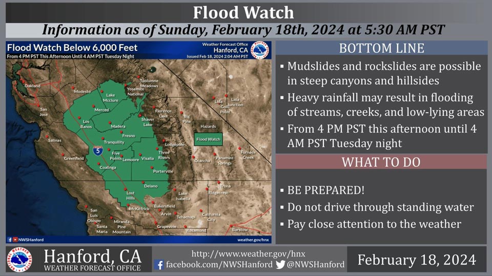
February 18, 2024 - National Weather Service Hanford Office officials report a Flood Watch remains in effect for most of Central California below 6,000 feet from 4:00 P.M. this afternoon until 4:00 A.M. Tuesday night.
The majority of this rain will fall this evening through Monday evening.
Excessive runoff may cause mudslides and rockslides in steep canyons and hillsides.
Heavy rainfall could result in flooding of streams, creeks, and low-lying areas.
Flood Watch
Flood Watch
National Weather Service Hanford CA
435 AM PST Sun Feb 18 2024

West Side Mountains north of 198-Los Banos - Dos Palos-Merced -
Madera - Mendota-Planada - Le Grand - Snelling-Coalinga - Avenal-
West Side of Fresno and Kings Counties-Caruthers - San Joaquin -
Selma-Fresno-Clovis-West Side Mountains South of 198-Buttonwillow
- Lost Hills - I5-Delano-Wasco-Shafter-Hanford - Corcoran -
Lemoore-Visalia - Porterville - Reedley-Southeast San Joaquin
Valley-Mariposa Madera Foothills-Mariposa-Madera Lower Sierra-
Fresno-Tulare Foothills-Fresno-Tulare Lower Sierra-South End
Sierra Foothills-South End of the Lower Sierra-Yosemite Valley-
San Joaquin River Canyon-
Including the cities of Tulare, Coarsegold, Buttonwillow, Five
Points, Camp Nelson, Kettleman City, Goshen, San Luis Reservoir,
Selma, Millerton Lake, Lemoore Station, Le Grand, Atwater,
Porterville, Mariposa, Kerman, Alpaugh, Parlier, Kingsburg,
Corcoran, Fresno, Lost Hills, Fish Camp, Madera, Shafter,
Hanford, North Fork, Los Banos, Planada, Lake Mcclure, Yosemite
Valley, Blackwells Corner, Richgrove, Wasco, Coalinga, Bass Lake,
Oakhurst, Lemoore, Avenal, McKittrick, Merced, El Portal, Delano,
Auberry, Visalia, and Sanger
435 AM PST Sun Feb 18 2024

...FLOOD WATCH REMAINS IN EFFECT FROM 4 PM PST THIS AFTERNOON
THROUGH WEDNESDAY MORNING...

* WHAT...Flooding caused by excessive rainfall continues to be
  possible.

* WHERE...A portion of central California, including the following
  areas, Buttonwillow - Lost Hills - I5, Caruthers - San Joaquin -
  Selma, Coalinga - Avenal, Delano-Wasco-Shafter, Fresno-Clovis,
  Fresno-Tulare Foothills, Fresno-Tulare Lower Sierra, Hanford -
  Corcoran - Lemoore, Los Banos - Dos Palos, Mariposa Madera
  Foothills, Mariposa-Madera Lower Sierra, Merced - Madera -
  Mendota, Planada - Le Grand - Snelling, San Joaquin River Canyon,
  South End Sierra Foothills, South End of the Lower Sierra,
  Southeast San Joaquin Valley, Visalia - Porterville - Reedley,
  West Side Mountains South of 198, West Side Mountains north of
  198, West Side of Fresno and Kings Counties and Yosemite Valley.

* WHEN...From 4 PM PST this afternoon through Wednesday morning.

* IMPACTS...Excessive runoff may result in flooding of rivers,
  creeks, streams, and other low-lying and flood-prone locations.
  Flooding may occur in poor drainage and urban areas. Storm drains
  and ditches may become clogged with debris. Mudslides and
  rockslides are possible in steep canyons and hillsides.

* ADDITIONAL DETAILS...
  - Potential for heavy rainfall.
  - http://www.weather.gov/safety/flood

PRECAUTIONARY/PREPAREDNESS ACTIONS...

You should monitor later forecasts and be alert for possible Flood
Warnings. Those living in areas prone to flooding should be prepared
to take action should flooding develop.
Source: NWS
