


California and National Drought Summary for February 20, 2024
Summary
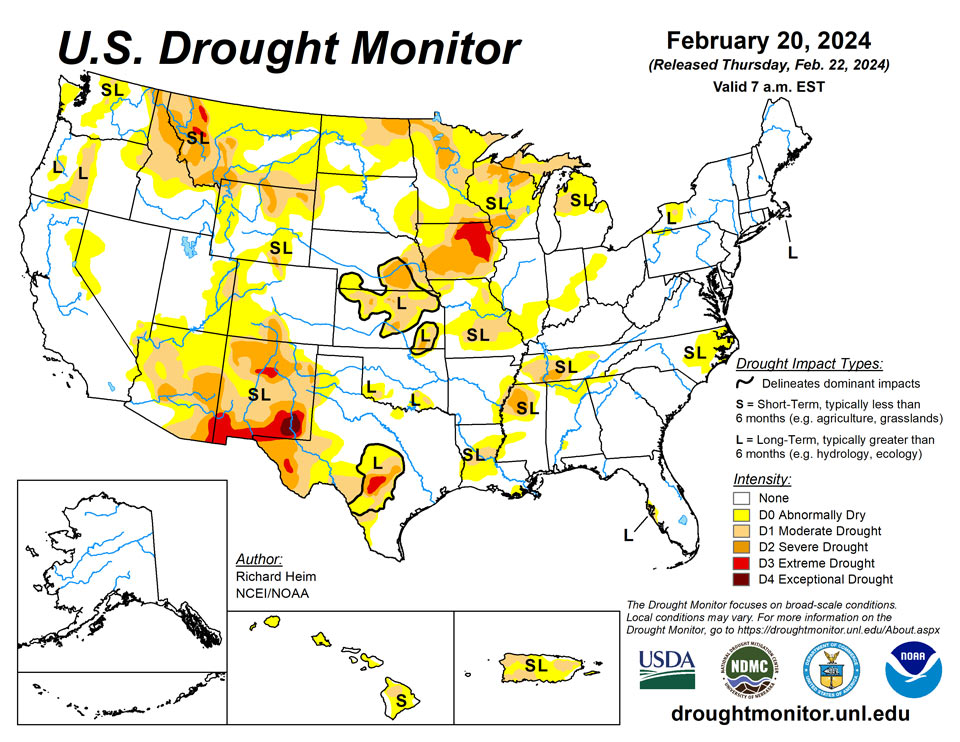
February 22, 2024 - An atmospheric river of Pacific storm systems slammed parts of the West Coast with heavy precipitation during this U.S. Drought Monitor (USDM) week (February 14-20). The weather systems dried out as they crossed the western mountains, then produced anemic precipitation amounts east of the Rockies. Parts of the Midwest and Northeast received limited precipitation amounts from passing cold fronts, and heavier rain fell along the Texas coast and across Florida from another frontal system, but much of the country east of the Rockies, as well as the southwestern U.S., received little to no precipitation. The weather systems distorted the upper-level circulation over the contiguous U.S. (CONUS), which otherwise consisted of a high-pressure ridge over western North America and a low-pressure trough over the east. The end result of this distortion was a temperature anomaly pattern that consisted of warmer-than-normal weekly temperatures in the Upper Midwest and parts of the interior West, and below-normal temperatures in the Pacific Northwest, Rockies, and southern tier states, with near-normal temperatures elsewhere. An upper-level ridge over the Caribbean brought generally dry and warmer-than-normal weather to Puerto Rico and the U.S. Virgin Islands, while ridges also kept Alaska mostly drier and warmer than normal and Hawaii drier than normal this week. Drought or abnormal dryness expanded or intensified this week in parts of the Pacific Northwest, northern Rockies, northern Plains, Upper Midwest, Middle Mississippi Valley, Rio Grande Valley, eastern North Carolina, and much of Hawaii. Drought or abnormal dryness contracted or reduced in intensity in parts of the Four Corners states and Lower Mississippi Valley.
Northeast
Half an inch or more of precipitation fell this week over parts of New York, Pennsylvania, New Jersey, and southern New England. The rest of the region received less than half an inch. A 1-category improvement was made in southern Massachusetts, based on recent precipitation and recovering groundwater – abnormal dryness ended on Cape Cod, moderate drought ended on Martha’s Vineyard, and severe drought improved to moderate drought on Nantucket. Much of New England and northern New York has been dry for the last 1 to 2 months, with the dryness especially acute for the last 1 to 3 months along the Canadian border. If the dry conditions persist, a strip of D0 (Abnormally Dry) may be needed from northern Maine to northern Vermont in the next month or two, but for now that area was left free of drought and abnormal dryness.
Southeast
Almost all of Florida received half an inch or more of rain this week, with parts of the Peninsula getting 2 inches or more. But the rest of the Southeast region got little to no precipitation. The last 30 days have been quite dry along the coast from southeast Virginia to South Carolina. D0 expanded in eastern North Carolina where streamflow and soil moisture are below normal and 30- to 60-day precipitation deficits have been the greatest.
South
Half an inch or more of precipitation fell across parts of the Texas coast, and there were a few areas of up to half an inch of precipitation in Arkansas and Tennessee, but otherwise the South region received no precipitation this week. D0 and D1 were expanded in west Texas along the Rio Grande Valley to reflect dry conditions over the last 7 days to 3 months, low streams, drying soils, and stressed vegetation indicated by satellite. D0 was contracted in South Texas and D1 contracted slightly in central Texas (Bell County). No change was made in Oklahoma, where reservoir levels remain historically low. A reassessment of conditions resulted in the removal of the D3 (extreme drought) and trimming of D2 in northwest Mississippi, trimming of D0-D1 in Arkansas, Louisiana, and Mississippi, and trimming of D0 in Tennessee. Precipitation is near to above normal in these areas for the last 1 to 4 months, streamflow is near to above normal, and surface soil moisture has been recharged. In Louisiana, stock ponds mostly refilled. The remaining D0-D2 is sufficient to reflect the longer-term dryness which shows up most severely at the 6- to 12-month time scales.
Midwest
A few areas received half an inch of precipitation, but most of the Midwest region saw only a couple tenths of an inch. Dry conditions over the last 1 to 6 months prompted the expansion of D0-D2 in Michigan and Wisconsin and D1 in southeast and northeast Minnesota. The lack of snow (“snow drought”) in Minnesota has had a sizable impact on winter recreation. D0 expanded slightly in northwest Iowa. D0 expanded in southern Illinois where the last 1-3 months have been dry, streamflow and water table levels are below normal, and reports of some field fires have been received. In eastern Missouri, D0 and D1 expanded to reflect lowering streams, drying soils, and 3- to 9-month precipitation deficits. Temperatures were 6 to 9 degrees above normal in northern parts of the region this week. The Midwest has experienced unusually warmer-than-normal temperatures during the last 1 to 2 months, with the last month averaging 6 degrees above normal along the Ohio Valley to over 15 degrees above normal in Minnesota. Since this is winter, vegetation is dormant and evapotranspiration is minimal. But in the weeks ahead, if the anomalous warmth persists as the region transitions into spring, evapotranspiration will increase, soils will dry, and the effects of the moisture stress, if rain isn’t sufficient, will need to be reflected in the USDM depiction.
High Plains
Half an inch to locally 2 inches of precipitation fell this week over the Colorado mountains into adjacent Wyoming, and over western Wyoming. A band of precipitation extended across South Dakota, with locally up to half an inch falling. Otherwise, the High Plains region received little to no precipitation. D0 was expanded in the Dakotas, and D1 expanded in North Dakota, where the last 3 months have been dry and the lack of snow cover has exposed bare ground. D0 and D1 were adjusted in north central and southwest Colorado where recent precipitation resulted in local improvements and continued dryness caused local expansion. D2 was introduced in north central and northeastern Wyoming.
West
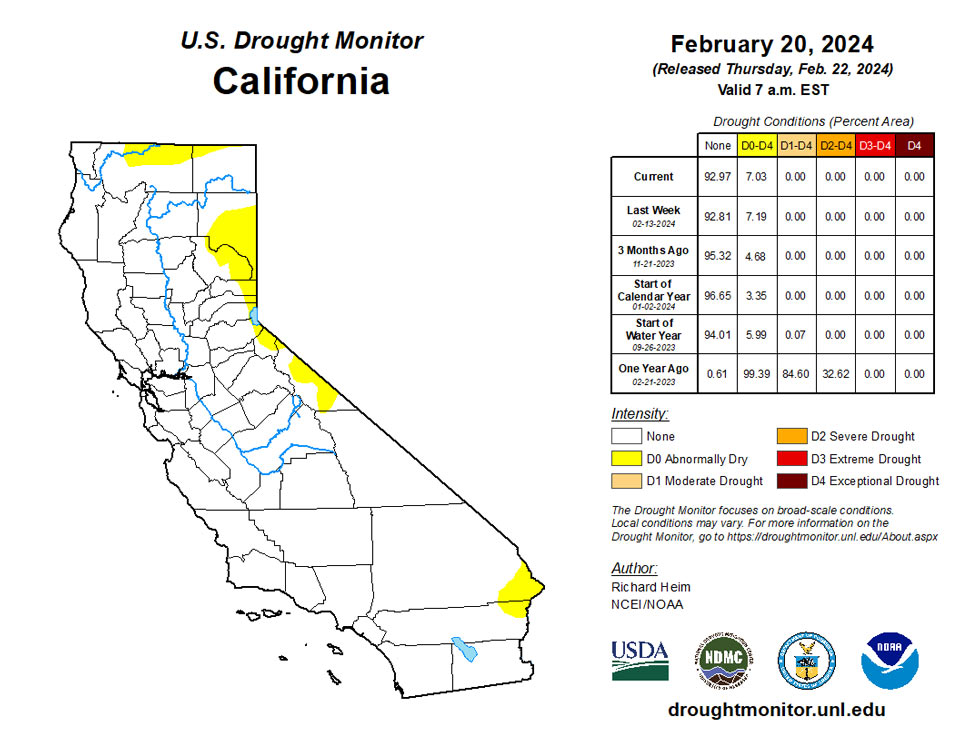
Five inches or more of precipitation fell along the California coast, across much of northern California, and in southwestern coastal Oregon, with 2 inches or more inland to the Sierra Nevada, Oregon Cascade mountain range, and over southwestern coastal Washington. Half an inch to an inch of precipitation fell across southern parts of the Pacific Northwest inland to the Rockies and a few areas to the north, with up to 2 inches falling from the Great Salt Lake area to Yellowstone National Park. Another area of 1 to 2 inches of precipitation occurred over the Colorado Rockies into adjacent Wyoming. Parts of California have received over 10 inches of precipitation during February and the Sierra Nevada range has received 1 to 3 feet of new snow since the end of January. But even with a wet February, much of the Sierra Nevada still has a below-normal snowpack. As of February 16, the northern Sierra snow water content (SWE) was 83% of normal, the central Sierra SWE was 74% of normal, and the southern Sierra SWE was 72% of normal. So, the D0 along the California-Nevada border was left unchanged.
While this week was dry across New Mexico, precipitation from the last 2 weeks to 3 months prompted the elimination of the D4 in southwestern New Mexico and the northwest D2, and contraction of the D3 in north central and D2 in southwestern parts of the state.
In northern parts of the West, precipitation for the water year to date (October 1, 2023-February 18, 2024) has been largely below normal and the winter snowpack is significantly below normal. Parts of the northern Rockies have record low SWE values, according to SNOTEL data. D0 expanded in parts of Idaho, Oregon, and Washington; spots of severe drought (D2) were added in north central and northeast Wyoming; and D2 was expanded and new D3 added in parts of Montana, especially the western and southern mountains, where the last 3 to 4 months have been dry and SWE values are record low.
Caribbean
Puerto Rico had a drier-than-normal and mostly warmer-than-normal week, following very wet conditions last week. Improvement was made last week, so no changes were made this week. The existing D0 and D1 reflect the dry soils, low streamflow, and longer-term dryness.
Tranquil weather returned across the U.S. Virgin Islands, following the previous week’s heavy rain. During the 7-day drought-monitoring period ending February 20, rainfall at all official and volunteer (CoCoRaHS) observation sites ranged from 0.00 to 0.04 inch. However, there were no changes to the depiction—long-term moderate drought (D1-L) continued on St. Thomas, while neither dryness nor drought was observed on St. John and St. Croix—as improvements from the early-February downpours continued to be reflected in groundwater and vegetation health. At the U.S. Geological Survey Adventure 28 Well on St. Croix, depth to water improved from 34.23 to 31.71 feet between February 3 and 14.
Pacific
This week was mostly drier and warmer than normal across Alaska. With SWE values mostly near to above normal, no change was made to the depiction, so Alaska continued free of drought and abnormal dryness. However, precipitation has been below normal for the water year to date (October 1, 2023-February 19, 2024) in southwest Alaska, including Cook Inlet and the Northwest Gulf area. And based on webcams, there is little to no significant snow in the mountains over the southern half of the Panhandle, and this region has had below-normal precipitation for the month of February. The snow drought situation in the southern Panhandle could have significant hydropower/water and environmental impacts by early summer if 1) there's no significant mountain snow in the next few weeks and 2) spring and early summer turn out comparatively dry and warm.
February has generally been dry across Hawaii, reflecting the drier-than-normal conditions usually associated with a strong El Nino event. Low rainfall and stream levels, in combination with impact reports from multiple sources, resulted in expansion of D0 on the Big Island and introduction of D0 on Kauai, Niihau, Oahu, Kahoolawe, and parts of Lanai and Maui.
El Niño-related short-term drought continued to gradually expand and intensify across portions of the U.S.-Affiliated Pacific Islands, with burgeoning impacts on vegetation health and fresh-water supplies. A notable exception was south of the Equator, in American Samoa, where heavy rain continued. During the first 20 days of February, 22.99 inches of rain fell at American Samoa’s Pago Pago International Airport.
Meanwhile, changes in the Federated States of Micronesia (FSM) for the drought-monitoring period ending February 20 included adding abnormal dryness (D0) for Nukuoro and Chuuk Lagoon, as well as deterioration from abnormally dry conditions to moderate drought (from D0 to D1) for Lukunor. Less than one-half inch of rain fell during the week at all FSM sites, except Kosrae (more than 5 inches) and Kapingamarangi (about an inch). In places such as Yap, Ulithi, and Pingelap, where drier-than-normal conditions began earlier, starting in November 2022, severe drought (D2) was solidly entrenched. Moderate drought (D1) was noted for Woleai and Pohnpei.
In the Mariana Islands, mid-February showers—with weekly rainfall totals near an inch—temporarily stabilized conditions, with moderate drought (D1) being reported again this week for Guam, Rota, and Saipan. Nevertheless, the Marianas are at risk of further drought deterioration, amid frequently dry, breezy conditions. Winds recently gusted to 40 mph at the international airports on Guam (on February 15) and Saipan (on February 14), and Guam had a Keetch-Byram Drought Index (KBDI) value of 663 on February 21, reflective of a very high fire danger.
Enough precipitation has been falling in the Republic of Palau to hold off on the introduction of abnormal dryness, although rainfall intensity has decreased in recent weeks.
Finally, no changes were introduced in the Republic of the Marshall Islands (RMI), despite a continuation of drier-than-normal weather. By February 20, the RMI depiction included severe drought (D2) for Wotje; moderate drought (D1) for Kwajalein; and abnormally dry conditions (D0) for Jaluit, Majuro, and Mili. Rainfall throughout the RMI totaled less than one-half inch at all observation sites until the end of the drought-monitoring period, when heavier showers arrived across some of the southern islands such as Jaluit, Ailinglapalap, and Majuro. For Majuro, reservoir storage has been somewhat resilient since the last heavy rain fell in early February, with 27.3 million gallons of fresh water available on February 15.
Looking Ahead
In the two days since the Tuesday valid time of this USDM, Pacific moisture continued to move across parts of the West, with little precipitation falling east of the Rockies. For February 22-27, one weather system will move across the eastern CONUS, while another moves into the West by the end of the period. The first is forecast to drop 0.5 to 1.5 inches of precipitation across the Tennessee Valley and southern Appalachians northward to the southern Great Lakes and central Appalachians, with half of an inch or less over the Northeast and even less over the Southeast. The second is expected to bring an inch or more of precipitation to the central and northern Rockies, coastal ranges of the Pacific Northwest, and Sierra Nevada, with up to 3 or 4 inches in the Washington Cascades. Other areas of the West are forecast to receive less than half an inch of precipitation, with little to no precipitation over the Southwest and to the lee of the Cascades in Washington. For the Great Plains to Mississippi Valley, little to no precipitation is predicted. Temperatures are expected to be warmer than normal, with the warmest anomalies across the Plains and Mississippi Valley due to upper-level ridging.
For much of the next 2 weeks, the atmospheric circulation is expected to consist of an upper-level trough over the western CONUS and a ridge over the eastern two-thirds of the country, with Pacific weather systems migrating through the trough/ridge pattern. The Climate Prediction Center’s (CPC) 6-10 Day Outlook (valid February 27-March 2) and 8-14 Day Outlook (valid February 29-March 6) favor a fairly stable pattern of warmer-than-normal temperatures from the Plains to East Coast and cooler-than-normal temperatures over the West and Alaska. The outlook is for above-normal precipitation over much of the CONUS, especially along the West Coast and Great Lakes, with odds favoring near to below-normal precipitation across the Plains and over most of Alaska.
Author(s):
Richard Heim, NOAA/NCEI
Brad Rippey, U.S. Department of Agriculture
Dryness Categories
D0 Abnormally Dry—used for areas showing dryness but not yet in drought, or for areas recovering from drought.
Drought Intensity Categories
D1 Moderate Drought
D2 Severe Drought
D3 Extreme Drought
D4 Exceptional Drought
Drought or Dryness Types
S Short-term, typically less than 6 months (agriculture, grasslands)
L Long-term, typically more than 6 months (hydrology, ecology)
SL Area contains both short- and long-term impacts
Source: National Drought Mitigation Center
