


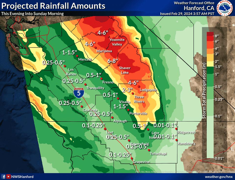
Mariposa and Yosemite Valley projected rainfall amounts: 4.00" to 6.00"
February 29, 2024 - National Weather Service Hanford Office officials report a strong storm system will impact Central California this evening into Sunday morning, resulting in periods of heavy precipitation.
Most of this precipitation will fall Friday evening through Saturday evening.
Snow levels will drop to around 2,500 feet Saturday evening.
Area Forecast Discussion
National Weather Service Hanford CA
1241 AM PST Thu Feb 29 2024
...DANGEROUS WINTER STORM TONIGHT INTO SUNDAY MORNING...
.KEY MESSAGES...
1. Blizzard conditions are expected in the Sierra Nevada north
of Tulare County tonight into Sunday morning.
2. Damaging winds and heavy snow could down trees and power
lines tonight into Sunday morning.
3. Extreme winter storm impacts are expected throughout the
Sierra Nevada tonight through Saturday evening due to blowing
snow, snow load, and snow amounts up to eight feet.
4. Impactful, low elevation snow likely in the Sierra Nevada
foothills from 2,500 feet to 4,000 feet Saturday evening into
Sunday morning.
5. Strong, gusty winds are possible in the Kern County desert
from 10 AM PST Saturday morning until 10 AM PST Sunday morning.
6. Light snow is conceivable along Interstate 5 over Tejon Pass
and along Highway 58 over Tehachapi Pass Saturday night and
Sunday morning.
&&
.DISCUSSION...
An Eastern Pacific trough of low pressure will approach the
coast of California today. Precipitation associated with this
trough of low pressure should begin this afternoon or this
evening. As this trough of low pressure strengthens near the
coast of California, precipitation will become heavier. Blizzard
conditions are anticipated in the Sierra Nevada north of Tulare
County tonight into Sunday morning. Damaging winds and heavy
snow may down trees and power lines tonight into Sunday
morning. Extreme winter storm impacts are expected throughout
the Sierra Nevada tonight through Saturday evening due to
blowing snow, snow load, and snow amounts up to eight feet.
There is a 25% probability of at least the following snow
amounts for selection locations in the Sierra Nevada from 4 PM
PST Thursday, February 29th, 2024 through 10 AM PST Sunday,
March 3rd, 2024:
Lake Wishon - 8 feet
Huntington Lake - 7 feet
Florence Lake - 7 feet
Tuolumne Meadows - 6 feet
Devils Postpile - 6 feet
Lodgepole - 5 feet
Lake Thomas Edison - 5 feet
Generally, snow amounts will be five to eight feet throughout
the Sierra Nevada for this event. Impactful, low elevation snow
will fall in the Sierra Nevada foothills from 2,500 feet to
4,000 feet Saturday evening into Sunday morning. A Winter Storm
Warning is in effect. Light snow is possible along Interstate 5
over Tehachapi Pass and along Highway 58 over Tehachapi Pass
Saturday night and Sunday morning. Snow amounts will be an inch
or less. Finally, strong, gusty west winds are possible in the
Kern County desert from 10 AM PST Saturday morning until 10 AM
PST Sunday morning. A Wind Advisory may be required.
Light snow may linger in the Sierra Nevada Sunday afternoon,
before ending Sunday night. A ridge of high pressure over the
Eastern Pacific Ocean will progress eastward across the Golden
State Monday and Tuesday. A storm system will move southward
just offshore of the Pacific Northwest Tuesday night.
Precipitation associated with this storm system may begin to
impact Central California Wednesday.
&&
.AVIATION...
VFR conditions will prevail today. MVFR or lower conditions are
likely tonight and Friday in and near precipitation.
&&
.AIR QUALITY ISSUES...
On Thursday, February 29th, 2024, fireplace/wood stove burning
status is: no burning unless registered in Fresno and Kern
Counties. Burning discouraged in Kings, Madera, Merced, and
Tulare Counties, as well as in Kern (Greater Frazier Park Area)
and Sequoia National Park and Forest.
&&
.CERTAINTY...
The level of certainty for days 1 and 2 is high.
The level of certainty for days 3 through 7 is medium.
Certainty levels include low, medium, and high. Please visit
www.weather.gov/hnx/certainty.html for additional information
and/or to provide feedback.
&&
.HNX WATCHES/WARNINGS/ADVISORIES...
Winter Storm Warning from 4 AM Saturday to 10 AM PST Sunday
for CAZ318-320-322-324-325-333.
Blizzard Warning from 4 PM this afternoon to 10 AM PST Sunday
for CAZ323-326>328.
Winter Storm Warning from 4 AM Friday to 10 AM PST Sunday for
CAZ329>331.
&&
$$
Public/Fire Weather...BS
Aviation/PIO..........MM
DSS...................DS
Source: NWS
