


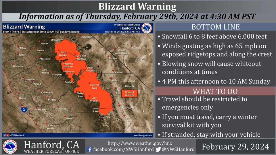
February 29, 2024 - National Weather Service Hanford Office officials report a Blizzard Warning is in effect for the Sierra Nevada north of Tulare County from 4:00 P.M. this afternoon until 10:00 A.M. Sunday morning.
The heaviest snow will fall Friday evening through Saturday evening.
Damaging winds and heavy snow could down trees and power lines.
Travel is not advised. If an emergency arises and you must travel, remember to carry a winter survival kit with you.
Blizzard Warning
URGENT - WINTER WEATHER MESSAGE
National Weather Service Hanford CA
938 AM PST Thu Feb 29 2024

CAZ323-326>328-010200-
/O.CON.KHNX.BZ.W.0001.240301T0000Z-240303T1800Z/
Yosemite NP outside of the valley-Upper San Joaquin River-
Kaiser to Rodgers Ridge-Kings Canyon NP-
Including the cities of Tuolumne Meadows, Wawona,
Devils Postpile, Florence Lake, Lake Thomas Edison, Lake Wishon,
Huntington Lake, Shaver Lake, and Cedar Grove
938 AM PST Thu Feb 29 2024

...BLIZZARD WARNING REMAINS IN EFFECT FROM 4 PM THIS AFTERNOON TO
10 AM PST SUNDAY...

* WHAT...Blizzard conditions expected. Snowfall 6 to 8 feet
  above 6,000 feet. Total snow 4 to 6 feet from 5,000 feet to
  6,000 feet. Snow accumulations 2 to 4 feet from 4,000 feet to
  5,000 feet. Winds gusting as high 65 mph on exposed ridgetops
  and along the crest.

* WHERE...Sierra Nevada north of Tulare County.

* WHEN...Winter storm impacts from 4 PM PST this afternoon until
  10 AM PST Sunday morning, with blizzard conditions expected
  Friday and Saturday.

* IMPACTS...Travel will be dangerous to impossible. Widespread
  blowing snow will reduce visibilities to near zero in whiteout
  conditions at times. Damaging winds and heavy snow could down
  trees and power lines. Wind chill readings as low as 15 to 20
  degrees below zero can cause frostbite on exposed skin.

PRECAUTIONARY/PREPAREDNESS ACTIONS...

Travel should be restricted to emergencies only. If you must
travel, have a winter survival kit with you. If you get stranded,
stay with your vehicle.

The latest road conditions for the state you are calling from can
be obtained by calling 5 1 1.
Source: NWS
