


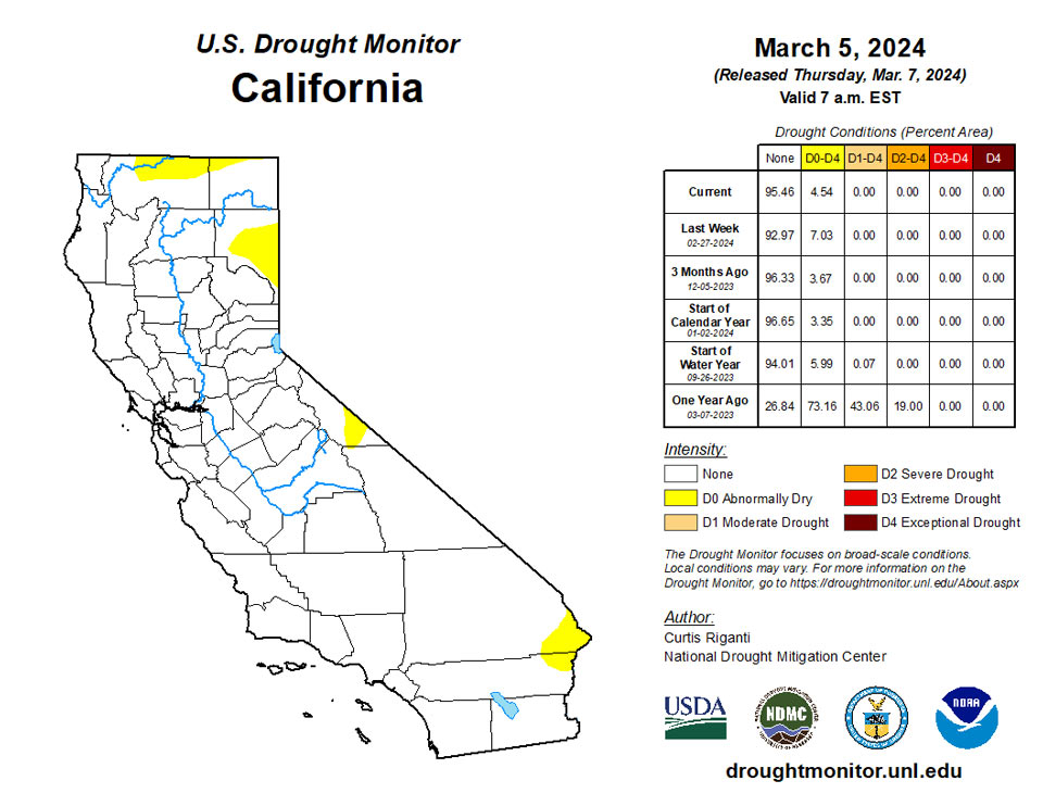
California and National Drought Summary for March 5, 2024
Summary
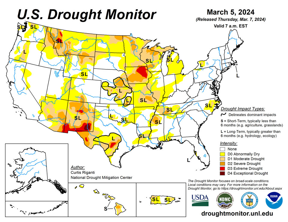
March 7, 2024 - Heavy precipitation fell across parts of the southern and eastern U.S., and in parts of the West, especially in the Sierra Nevada, where a major blizzard significantly increased snowpack in that range. The Great Plains were mostly dry this week, as were parts of the Midwest, except for rain in parts of Illinois, southeast Wisconsin and Michigan. Recent rainfall improved conditions across much of Puerto Rico. Hawaii has been in a trade wind pattern recently, leading to wet weather on the windward sides of the islands but drier conditions on the leeward sides. Thus, a mix of improvements and degradations occurred there. Temperatures were near or below normal in much of the western U.S. west of the Continental Divide. In most of the central and eastern U.S., temperatures were near or above normal, especially in the Upper Midwest and Great Lakes, where temperatures from 10 to 15 degrees warmer than normal were common. A few spots in the Great Lakes area checked in even warmer than that, with readings 15-20 degrees above normal.
Northeast
Aside from parts of northern New England and northwest New York, much of the Northeast saw at least a half inch of precipitation this week. Short-term dryness in parts of northwest New York, combined with lowering streamflows, led to some minor expansion of moderate drought and abnormal dryness where long-term dryness was already lingering. Recent precipitation has accumulated enough and improved groundwater levels enough on Martha’s Vineyard for the removal of abnormal dryness there, though long-term moderate drought continued on Nantucket. Elsewhere, the Northeast remained free of drought or abnormal dryness.
Southeast
Widespread rain amounts of a half inch or more fell across much of the Southeast region this week, except for Florida, where rains were spottier. Temperatures ranged from near normal to 5-10 degrees above normal across most of the Southeast. Moderate drought in eastern North Carolina, and surrounding abnormal dryness, was reduced following heavy rains this week, which also improved soil moisture and streamflow levels. Localized improvements to abnormal dryness also occurred in Alabama after heavy rainfall this week. Elsewhere across the region, no changes were made to the ongoing drought depiction, as most of the region remained free of drought or abnormal dryness.
South
Moderate to heavy rain amounts fell across portions of Louisiana and Mississippi this week. Elsewhere, mostly dry weather occurred in the region, aside from isolated heavy rain from a thunderstorm in north-central Arkansas. Temperatures across the region were mostly either near normal or 5-10 degrees above normal, with a few spots in Texas coming in 5-10 degrees below normal. Recent rainfall continued to alleviate precipitation deficits in eastern Louisiana and in Mississippi, leading to some improvements in areas of moderate drought and abnormal dryness. In southwest Louisiana, short-term dryness and warmth and lowering streamflow levels led to a small expansion of moderate drought conditions. Abnormal dryness spread across parts of northern and western Arkansas, and a few isolated spots in Texas and Oklahoma, given short-term precipitation deficits, warm and windy weather, and low soil moisture.
Midwest
Rain and thunderstorms (with some severe weather) spread across parts of central and northern Illinois, southern Wisconsin, and Michigan this week. Half an inch to 2 inches of rain fell across much of central and eastern Kentucky as well. In areas of heaviest rainfall in northern Illinois, adjacent southern Wisconsin and the northern Michigan Lower Peninsula, areas of moderate drought and abnormal dryness were improved. Farther south in Illinois and Missouri, abnormal dryness and moderate drought expanded in coverage as short-term precipitation deficits grew amid warm and windy weather and lowering soil moisture levels. An area of severe drought developed southwest of St. Louis where streamflow deficits also worsened. Moderate and severe drought locally increased in coverage in northeast Minnesota and nearby northern Wisconsin and the adjacent Michigan Upper Peninsula, as precipitation deficits mounted along with warmer-than-normal weather. A significant snow drought continued in the region, as Duluth, Minnesota, is now 50 inches below normal for snowfall this season, according to the Minnesota State Climate Office. Short- and long-term precipitation deficits, warm and windy recent weather, and low soil moisture and groundwater levels led to a localized expansion of extreme drought in central Iowa. In southeast Iowa, despite wetter weather in January, creeks, rivers and pond levels are still low, indicative of the short- and long-term significant drought conditions across much of Iowa.
High Plains
Mostly dry weather occurred in the Great Plains portion of the High Plains region this week. Temperatures in the region ranged from mostly 5-10 degrees warmer than normal for far eastern Wyoming and Colorado and most of Kansas, Nebraska and South Dakota, to near or below normal temperatures in North Dakota, western Colorado and western Wyoming. Some of the mountainous parts of the region received significant snowfall, especially in west-central and northwest Wyoming and in the Medicine Bow Mountains in northern Colorado and south-central Wyoming. Improving snowpack levels led to reductions in coverage of moderate and severe drought and abnormal dryness in these areas, though improvements were more limited in southern Wyoming, where grass fires were reported west of Cheyenne recently and only light snow amounts were reported in the high plains west of Laramie. Given short-term dryness and high recent evaporative demand, abnormal dryness and moderate drought were expanded in northwest South Dakota, southwest North Dakota, and adjacent southeast Montana.
West
Heavy precipitation fell this week across much of the central and northern Pacific Coast, and heavy snow also fell in a major storm in the Sierra Nevada. Significant snow amounts also fell across parts of Idaho and northwest and southwest Montana. Improving snowpack in these areas and lessening precipitation deficits led to improvements in drought or abnormal dryness in numerous locations. Recent precipitation in western and central Oregon continued to chip away at long-term precipitation deficits, leading to the removal of one long-term moderate drought area and coverage reductions of another. Meacher and Park counties in Montana have missed out on recent snowfall, leaving current snowpack numbers very low, and moderate drought worsened to severe drought. Heavy precipitation in northwest Washington (with some locations likely seeing over 9 inches of liquid precipitation) led to a reduction in moderate drought and abnormal dryness coverage. Along the Arizona-New Mexico border, severe drought coverage was locally reduced in a reassessment of short- and long-term drought conditions.
Caribbean
Recent rain events in Puerto Rico led to widespread improvement in moderate drought and abnormal dryness there, leaving a few areas of moderate drought or abnormal dryness across the eastern and western portions of the island. In areas experiencing improving conditions, short-term precipitation deficits lessened, reservoir levels increased and streamflow levels improved.
The U.S. Virgin Islands received adequate rainfall during the past week for St. Thomas to improve to D0 (abnormally dry), while St. Croix and St. John remain free of drought. Local weather observers reported more than 2 inches of rain on St. Thomas in the past week, 0.33 to 0.77 for St. Croix, and 0.79 for St. John. The Standardized Precipitation Index for Windswept Beach on St. John indicated neutral or wet conditions at all time scales.
The Vegetation Health Index indicated good conditions for St. Thomas and St. John, and some areas of stress on St. Croix. Recent rainfall in the past month has increased water levels in the wells on all islands.
Pacific
With a few exceptions in the western portion of the state, precipitation amounts were mostly below normal this week in Alaska. Temperatures were mostly 2-8 degrees warmer than normal, except for southeast Alaska, where temperatures ranged from mostly near normal to 4-6 degrees below normal. Alaska remained free of drought or abnormal dryness this week.
In Hawaii, northeasterly trade winds were the primary weather pattern this week, leading to wetter weather on the windward sides of the islands and drier weather on the leeward (southwest) sides. Accordingly, drought or dryness improved in eastern and northeastern parts of the Big Island, while degradation (including the development of severe drought) occurred in central and parts of the western regions of the Big Island. Moderate drought developed on the southwestern slopes of Maui. On Molokai, short-term abnormal dryness developed on the west side of the island. Wet weather in eastern Oahu, including the Koolau Range, led to the removal of abnormal dryness there. Wet recent weather also led to the removal of abnormal dryness from northeastern portions of Kauai.
The Republic of Palau received ample rain with 2.92 inches at Koror and 5.49 inches at Palau IAP. Water supplies should be adequate as two inches of rain per week is enough to meet minimum water needs.
The Mariana Islands all remained in drought. Guam received 0.28 inches of rainfall this week. Weeks of low precipitation led to the introduction of D2, severe drought, for the island. Moderate drought, D1, continued for Rota, where 0.37 inches fell. Saipan remained at D2 and received 0.53 inches or less at its weather stations. These islands need an inch weekly to meet minimum water needs.
Precipitation for the Federal States of Micronesia was mixed with Kapingamarangi, Lukunor, and Nukuoro receiving more than 4 inches. Lukunor and Nukuoro remained abnormally dry this week. Kosrae received 0.80 inches and was in normal condition. Chuuk and Pohnpei also were at D0, receiving 0.07 and 0.58 inches, respectively. Pingelap, Ulithi, and Yap were all at D2, while Woleai was at D1.
The Marshall Islands all received less than half an inch of precipitation for the week. Ailinglaplap and Jaluit reported ample rainfall the previous week. Jaluit remained in D0, having been dry for a few weeks, while Ailinglaplap was drought-free. Kwajalein and Wotje both had virtually no rain and remained at D2. Majuro was at D0 and received 0.33 inches. The Majuro reservoir, however, held 24.363 million gallons on March 3, and the level was dropping rapidly. Some household water supplies were low.
American Samoa remained free of dryness. Pago Pago, Siufaga Ridge and Toa Ridge received from just under an inch to more than two inches of rain. Two inches of precipitation weekly is the amount these islands need to meet minimum water needs. Unusually warm sea surface temperatures contributed to unusually warm air temperatures recently.
Looking Ahead
Through the evening of Monday, March 11, the National Weather Service Weather Prediction Center is forecasting widespread precipitation amounts of at least a half inch across much of the central and eastern U.S. (roughly from the Interstate 35 corridor eastward), excluding northern Wisconsin, Minnesota, the Michigan Upper Peninsula, the Florida Peninsula, and central and south Texas. Within this area of precipitation, swaths of at least 1.5 inches of liquid precipitation are forecast from southwest Missouri to southeast Michigan, from southwest Mississippi to central North Carolina, and across most of New England. In the West, mostly drier weather is expected, though some higher precipitation amounts can be expected in the western mountains of northern California, western Oregon and western Washington.
Looking ahead to March 12-16, the National Weather Service Climate Prediction Center forecast favors warmer-than-normal temperatures across the central and eastern U.S., with the highest confidence for warmer-than-normal weather centered around the Upper Midwest and Great Lakes. The forecast favors near- or below-normal temperatures in the Intermountain West, and above-normal temperatures along the West Coast. Above-normal precipitation is favored across large portions of the central and southern U.S., especially in Colorado and New Mexico and the adjacent western Great Plains and in the Deep South and along the Central Gulf Coast. The forecast favors below-normal precipitation along the West Coast. In Alaska, above-normal precipitation is favored in the central and eastern parts of the state, while drier-than-normal weather is favored in the northwest. Colder-than-normal weather is forecast in the central and western portion of Alaska, while southeast Alaska is likely to be warmer than normal. Cooler-than-normal weather is favored in Hawaii along with near-normal precipitation.
Author(s):
Curtis Riganti, National Drought Mitigation Center
Denise Gutzmer, National Drought Mitigation Center
Dryness Categories
D0 Abnormally Dry—used for areas showing dryness but not yet in drought, or for areas recovering from drought.
Drought Intensity Categories
D1 Moderate Drought
D2 Severe Drought
D3 Extreme Drought
D4 Exceptional Drought
Drought or Dryness Types
S Short-term, typically less than 6 months (agriculture, grasslands)
L Long-term, typically more than 6 months (hydrology, ecology)
SL Area contains both short- and long-term impacts
Source: National Drought Mitigation Center
