


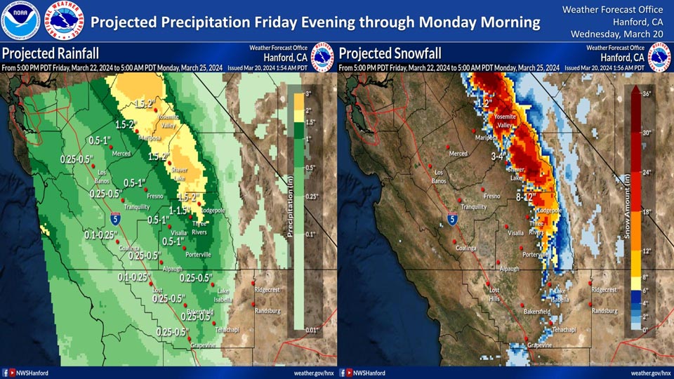
Projected rainfall for Mariposa and Yosemite Valley: 1.50" to 2.00"
March 20, 2024 - National Weather Service Hanford Office officials report light to moderate rain and mountain snow are expected in central California Friday evening through Monday morning.
Here are the current projected rainfall and snowfall amounts.
Area Forecast Discussion
National Weather Service Hanford CA
213 AM PDT Wed Mar 20 2024
.KEY MESSAGES...
1. There is a better than 50 percent chance of high
temperatures reaching at least 75 degrees at several locations
this afternoon.
2. A gradual cooling trend begins today with below normal
temperatures Saturday through Monday.
3. A 10-20 percent probability of thunderstorms in the San
Joaquin Valley Friday afternoon and evenings.
4. The next storm system will impact Central California by this
weekend, resulting in periods of precipitation.
&&
.DISCUSSION...
The stubborn upper low that has impacted the region over the
past several days will make its way to the east today. This will
leave a very short lived, very weak, induced ridge over
California as an upper low over the northeast Pacific digs a
trough south towards the region. This trough begins to impact
the region on Friday as the flow turns southwest and upper level
heights begin to drop quickly. This trough transverses the
region through the weekend leaving northwest flow aloft by
Monday that continues into the middle of next week.
The exiting upper low will allow upper heights to begin to rise
keeping mountain showers fairly suppressed. Temperatures in the
San Joaquin Valley PoE of 80 is only 2-16% for today, and PoE of
75 ranges as follows. Now in the Kern county desert high
temperatures today have a PoE of 80 that ranges from 11% at
Edwards AFB to 86% at China Lake NAF.
PoE of 75 degrees for selected locations for today:
Merced 46% Madera 71%
Fresno 91% Reedley 76%
Lemoore NAS 81% Hanford 81%
Visalia 81% Porterville 51%
Bakersfield 56% Mojave 11%
Edwards AFB 96% China Lake >99%
On Thursday the weak ridge continues aloft for another mild day
across the region. The PoE of 75 degrees lowers around 10%
across the board with the exception of China Lake that is most
certain at greater than 99% probability of exceeding 75 and
even 76% probability of exceeding the 80 mark.
Friday brings the change in the pattern for the region. The
upper trough digs into California and upper heights lower for
the area. The other feature is a fairly strong jet stream max
where at 250 MB it is expected at top out give or take at 180
kts that is fairly stout. This puts the region in the left exit
region of the jet max. This area has the best enhancement for
the development of thunderstorms. Digging deeper lapse rates in
the mid level average right around 7 degrees per km that support
thunderstorms activity with the most favorable areas being the
San Joaquin Valley mainly the north end of the valley. The
mitigating factor is limited convective potential energy that
is focused on the northern valley. The probability of
thunderstorms from the NBM ensembles at the follow stations for
Friday afternoon and evening are as follows:
Merced 25% Madera 24%
Fresno 24% Lemoore NAS 18%
Hanford 19% Visalia 20%
Delano 12% Bakersfield 12%
On Saturday the focus switches to precipitation with rainfall
in the lower levels and snow at higher elevations. The snow
level falls to around 5,000 feet at the peak of the event. The
PoE of 12 inches of snow on Saturday into Sunday increases to
around 10% at 7,000 feet and up to 60% at 10,000 feet. On the
warmer side with rainfall PoE of 1/4 inch is less than 10% for
the central San Joaquin Valley and increases towards the
foothills and approaches 100% in the Sierra Nevada. A table of
PoE of 1/4 inch is as follows:
Merced 57% Madera 40%
Fresno 45% Lemoore NAS 9%
Hanford 25% Visalia 23%
Porterville 20% Bakersfield 7%
On Sunday the storm beings to weaken as probabilities lower for
precipitation and snowfall for lower impacts to the region.
Monday and Tuesday the flow turns northwest limiting any
precipitation to the northern Sierra.
Wednesday temperatures will range near normal as the flow goes
westerly with an upper wave moving across the Pacific Northwest.
&&
.AVIATION...
Ground fog is a possibility for the San Joaquin Valley mainly
from Highway 198 and north during the 13-16Z period however
should not be deep enough to cause a reduction in flight
category. Otherwise sunglasses and VFR for the region for the
next 24 hours.
&&
.AIR QUALITY ISSUES...
ISSUED: 03/19/2024 14:09
EXPIRES: 03/20/2024 23:59
None.
&&
.CERTAINTY...
The level of certainty for days 1 and 2 is high.
The level of certainty for days 3 through 7 is medium.
Certainty levels include low...medium...and high. Please visit
www.weather.gov/hnx/certainty.html for additional information
and/or to provide feedback.
&&
.HNX WATCHES/WARNINGS/ADVISORIES...
None.
Source: NWS
