


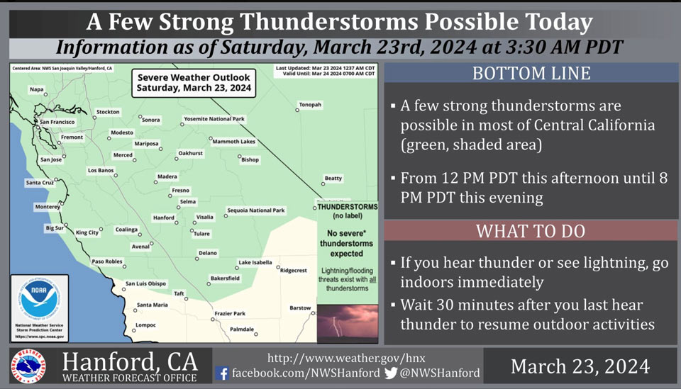
Possible Thunderstorms in Mariposa, Madera, Fresno and Tuolumne Counties
March 23, 2024 - National Weather Service Hanford Office officials report a few strong thunderstorms are possible in most of Central California from 12 PM PDT this afternoon until 8 PM PDT this evening.
Wind gusts near 45 miles per hour and small hail are a couple of hazards associated with strong thunderstorms.
In addition to dangerous cloud to ground lightning strikes, any thunderstorm can produce intense rainfall rates, leading to localized flooding.
Area Forecast Discussion
National Weather Service Hanford CA
256 AM PDT Sat Mar 23 2024
&&
.KEY MESSAGES...
1. A storm system will impact Central California this weekend
bringing periods of moderate rainfall to the San Joaquin Valley
and moderate to heavy snowfall in the Sierra Nevada.
2. Stronger winds are expected in the Kern County Desert later
today. Sustained west winds of 30 to 40 mph with gusts up to 60
mph are anticipated.
3. There is a 10-30 percent chance for thunderstorms in the San
Joaquin Valley this afternoon.
4.Another storm system will impact the area by the middle of
next week, beginning on Wednesday.
&&
.DISCUSSION...
An upper level low pressure system is currently located off the
coast of the Pacific Northwest region. The cyclonic flow around
the system is resulting in synoptic-scale forcing from the south
to southwest over Central California. This large-scale motion is
increasing moisture over the region, contributing to rain
showers in the San Joaquin Valley and snow showers in the Sierra
Nevada. These conditions are expected to continue through the
weekend as the aforementioned system moves on shore, with much
of the San Joaquin Valley having a moderate to likely
probability (40-80%) for 0.25 inches of rainfall through 11 PM
PDT this evening. A few thunderstorms are possible this
afternoon among periods of stratiform rainfall in the Central
Valley as instability increases over the region. Temperatures
will continue to fall today and Sunday as the surface flow turns
towards the northwest. Afternoon highs in the San Joaquin Valley
and Kern County Desert are anticipated in the low to mid 60s
today and Sunday, around five to ten degrees cooler than
seasonal averages and up to fifteen degrees cooler than Friday.
The following are probabilities from NBM ensemble guidance for
select areas of the San Joaquin Valley to meet or exceed 65
degrees this afternoon.
Bakersfield 26%Delano 26%Hanford 26%
Lemoore 26%Fresno 21%Visalia 16%
Madeira 6%Reedley 2%Porterville 2%
Merced 0%
In addition to the conditions mentioned above, the shift in
flow over the region is expected to bring an increase in winds
at the peaks of the Sierra Nevada and in the Kern County Desert;
maximum gusts are anticipated this evening into Sunday morning.
Ensemble guidance from the HREF expresses a 50-80% probability
of wind gusts of 55 miles per hour or greater in the Mojave
Slopes, with a greater than 80% probability at the conjuncture
of California Highway 14 and US Highway 395. As such, a Wind
Advisory remains in effect for this area until 11 PM PDT Sunday.
A Winter Storm Warning remains in effect for the Sierra Nevada
from Yosemite National Park south to Tulare County due to
Moderate to Major winter storm impacts associated with this
system. There is a 40-70% chance for greater than eight inches
of snowfall between 6,000 and 7,000 feet in association with
this system, with totals of two to three feet possible at the
highest elevations of the Sierra Nevada.
Early next week will bring a slight reprieve in these cool, wet
conditions as the aforementioned upper level system continues to
move eastward towards the central contiguous US. Temperatures
will be slow to recover as the flow through the atmosphere
continues from the northwest. Afternoon highs on Monday will
struggle to exit the mid 60s, according to probabilistic
guidance, which gives the San Joaquin Valley a 15-40% chance of
exceeding 65 degrees. A weak upper level ridge will build in
Tuesday, resulting in stable conditions and a return to seasonal
temperatures. Mid-term cluster analysis indicates the potential
for another upper level system bringing similar impacts as those
occurring this weekend to Central California mid to late next
week.
&&
.AVIATION...
MVFR in showers in the San Joaquin Valley and adjacent
foothills, with IFR and mountain obscurations due to RA/SN in
Sierra Nevada. There is a slight chance for thunderstorms again
this afternoon to evening from 21Z Sat until 03Z Sun, mainly
north of KBFL. Otherwise, VFR conditions will prevail across the
central CA interior for the next 24 hours.
&&
.AIR QUALITY ISSUES...
ISSUED: 03/22/2024 14:08
EXPIRES: 03/23/2024 23:59
None.
&&
.CERTAINTY...
The level of certainty for days 1 and 2 is medium.
The level of certainty for days 3 through 7 is medium.
Certainty levels include low...medium...and high. Please visit
www.weather.gov/hnx/certainty.html for additional information
and/or to provide feedback.
&&
.HNX WATCHES/WARNINGS/ADVISORIES...
Wind Advisory from 8 AM this morning to 11 PM PDT Sunday for
CAZ337>339.
Winter Storm Warning until 5 PM PDT Sunday for CAZ323-326>331.
&&
Source: NWS
