


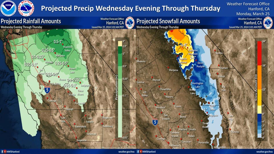
Projected rainfall for Mariposa: 0.25" to 0.50"
Projected rainfall for Yosemite Valley: 0.50" to 1.00"
March 25, 2024 - National Weather Service Hanford Office officials report a weak storm system will impact Central California Wednesday evening through Thursday, resulting in periods of precipitation north of Kern County.
The majority of this precipitation will fall Wednesday night and Thursday morning. The snow level will be around 6,000 feet.
Area Forecast Discussion
National Weather Service Hanford CA
309 AM PDT Mon Mar 25 2024
&&
.KEY MESSAGES...
1. Strong west winds 30 to 40 miles per hour with gusts up to 60
miles per hour are expected this afternoon into Tuesday morning
in the Mojave Slopes. A Wind Advisory has been issued for this
area.
2. A warming trend will set up through midweek. Afternoon
temperatures have a 60 to 90 percent chance to exceed 70
degrees Wednesday.
3. Another system arrives later this week, bringing rainfall to
the San Joaquin Valley along with rain and snowfall to the
Sierra Nevada and adjacent foothills.
&&
.DISCUSSION...
The upper level system impacting Central California over the
weekend has continued its march eastward through the contiguous
US, placing our forecast area in the upstream region of the
trough. As such, atmospheric flow is expected from the northwest
today and Tuesday, bringing a slight warming trend to our CWA;
maximum temperatures will return to seasonal averages Tuesday
afternoon. Stronger wind gusts are expected in the Mojave Slopes
again this afternoon into Tuesday morning due to the uniform
wind direction from the northwest. HREF ensemble guidance gives
greater than a 70% probability for wind gusts over 55 miles per
hour (48 knots) at the conjuncture of California Highways 14 and
58 near Mojave. As such, a Wind Advisory has been issued for
this area from 3 PM PDT this afternoon until 6 AM PDT Tuesday
morning. Lingering amounts of moisture from the north Pacific
will bring partly to mostly cloudy conditions to the region on
Monday, with slight chances for light rain and snowfall in the
Sierra Nevada. Probabilistic guidance from the HREF shows a
30 to 70 percent chance for measurable snowfall, however
probabilities fall below 20 percent for greater than one inch
except at the highest elevations.
The warming trend over Central California will continue as
another upper level system approaches the Pacific Northwest on
Wednesday, shifting the flow over our forecast area to the
southwest. Probabilistic guidance from the NBM points towards
much of the San Joaquin Valley having a 60 to 90 percent chance
of afternoon temperatures 70 degrees or greater. A band of
moisture associated with this upper level system is expected to
move over Central California beginning Wednesday afternoon,
bringing the next chance for precipitation to the region. The
NBM isnt too keen on large amounts of precipitation with this
initial push of moisture and suggests a low to moderate (10 to
40 percent) probability for rainfall accumulations 0.1 inches
or greater in the San Joaquin Valley between Wednesday afternoon
and Thursday afternoon.
However, cluster analysis has a strong agreement that the
aforementioned upper level system will gradually deepen
southward late this week, allowing for a multi-day stream of
moisture to set up over Central California through the weekend.
Early indications from the NBM gives a 20-50% chance for half an
inch of precipitation in the San Joaquin Valley between Friday
morning and Sunday morning. Snowfall is projected to once again
have an impact on the Sierra Nevada, with probabilistic guidance
suggesting a 30 to 60 percent chance for at least eight inches
of snowfall above 6,000 feet during the same time frame.
&&
.AVIATION...
Mountain obscuring MVFR or lower conditions are possible in the Kern
County mountains until 18Z this morning and in the majority of
the Sierra Nevada after 00Z this afternoon. Otherwise VFR
conditions will prevail across Central California for the next
24 hours.
&&
.AIR QUALITY ISSUES...
ISSUED: 03/24/2024 13:17
EXPIRES: 03/25/2024 23:59
None.
&&
.CERTAINTY...
The level of certainty for days 1 and 2 is high.
The level of certainty for days 3 through 7 is medium.
Certainty levels include low...medium...and high. Please visit
www.weather.gov/hnx/certainty.html for additional information
and/or to provide feedback.
&&
.HNX WATCHES/WARNINGS/ADVISORIES...
Wind Advisory from 3 PM this afternoon to 6 AM PDT Tuesday for
CAZ338.
Winter Weather Advisory until 5 AM PDT early this morning for
CAZ333>336.
Source: NWS
