


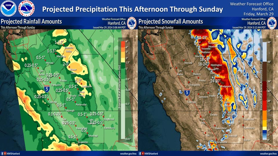
Projected rainfall for Mariposa: 1.00" to 1.50"
Projected rainfall for Yosemite Valley: 1.00" to 1.50"
March 29, 2024 - National Weather Service Hanford Office officials report a significant storm system will impact Central California this afternoon through Sunday, resulting in periods of precipitation.The majority of this precipitation will fall Friday night and Saturday. The snow level will be around 5,000 feet.
Area Forecast Discussion
National Weather Service Hanford CA
303 AM PDT Fri Mar 29 2024
.KEY MESSAGES...
1. A Wind Advisory will be in effect from 2 PM this afternoon
through 11 PM this evening for the Mojave Desert Slopes and the
Kern County Desert with wind gusts up to 50 mph.
2. A Wind Advisory is in effect along the higher terrain adjacent
to the west side of the San Joaquin Valley, the San Joaquin
Valley in mainly Merced and Madera Counties, and the Sierra
Nevada foothills in mainly Madera and Mariposa Counties from
this afternoon until this evening/early Saturday morning.
3. There is a 50-70% chance of major Winter Storm impacts in
the Sierra Nevada this weekend.
4. A Winter Storm Warning remains in effect for the Sierra Nevada
later this morning through Sunday afternoon. Badger Pass and
Lake Wishon have a 90% chance of at least 18 inches of new snow
with this event.
5. A Winter Storm Warning is in effect for the Kern County mountains
above 5,000 feet from this afternoon until Sunday. Pine
Mountain Club has around a 35% chance of at least 6 inches of
new snow with this event.
&&
.DISCUSSION...
Relatively quiet weather prevails for now, but the incoming low
pressure system remains on track to arrive in our forecast area
later today. Gusty winds, rain, and mountain snow begin by this
afternoon in our northern areas. Gusty winds will redevelop in
the desert areas of eastern Kern County by this afternoon, so we
have issued another Wind Advisory to cover this next portion of
the wind event. In addition, winds will pick up this afternoon
in the hills/mountains adjacent to the west side of the San
Joaquin Valley and in the Madera County and Merced County
portions, as well as the Sierra Nevada foothills in Madera and
Mariposa Counties. So, we have a Wind Advisory in effect for
these areas from this afternoon until late this evening/early
Saturday morning. Otherwise, precipitation will spread
southward, including as far as Kern County beginning later this
afternoon.
Overall, expect moderate impacts with this weekends system, except
there is a good chance (up to 70 percent chance) for major
impacts due to heavy snow in the higher elevations of the Sierra
Nevada. Also, were still seeing around a 70 to 90 percent
chance of a total 18 inches or greater of snow accumulations
for later today until Sunday in quite a few Sierra Nevada
locations. The chances for 0.25 inch of rain throughout the San
Joaquin Valley later today into Saturday will be around 50 to
75 percent. Rain amounts in the foothills into the lower Sierra
Nevada have anywhere from a 40 to around a 70 percent chance of
at least one inch of rain by Saturday morning. Snow levels will
range from about 4,000 to 5,000 feet for the duration of the
storm, although the heaviest amounts will fall mainly from 5,000
feet and above in the Sierra Nevada and Kern County mountains.
There is a slight chance for thunderstorms on Saturday afternoon
and evening as the atmosphere will be colder and more unstable.
On Saturday night into Easter Sunday, enough instability and
residual moisture will produce a continued chance of showers,
although precipitation will become more gradual. There remains a
low (up to 20 percent) chance of a dusting of snow on the
Grapevine, mainly from the Kern County line to around Lebec,
for Saturday night into Sunday morning. Otherwise, cooler than
normal temperatures will close out the month.
A relatively quiet weather pattern occurs for the first part of
next week, or on Monday through Wednesday. A weak system
arrives later next week and brings a slight chance for
precipitation to mainly the Sierra Nevada on Thursday until
Friday of next week.
&&
.AVIATION...
VFR conditions will prevail across Central California for at
least the next 24 hours.
&&
.AIR QUALITY ISSUES...
ISSUED: 03/28/2024 14:24
EXPIRES: 03/29/2024 23:59
None.
&&
.CERTAINTY...
The level of certainty for days 1 and 2 is high.
The level of certainty for days 3 through 7 is medium.
Certainty levels include low...medium...and high. Please visit
www.weather.gov/hnx/certainty.html for additional information
and/or to provide feedback.
&&
.HNX WATCHES/WARNINGS/ADVISORIES...
Wind Advisory from 2 PM this afternoon to 11 PM PDT this
evening for CAZ337>339.
Wind Advisory from 3 PM this afternoon to 6 AM PDT Saturday
for CAZ300-308-313.
Wind Advisory from 3 PM this afternoon to 11 PM PDT this
evening for CAZ301>303-317.
Winter Storm Warning from 11 AM this morning to 5 PM PDT
Sunday for CAZ323-326>331.
Winter Storm Warning above 5000 feet from 4 PM this afternoon
to 5 PM PDT Sunday for CAZ333-334.
Winter Storm Warning above 5000 feet from 4 PM this afternoon
to 11 PM PDT Sunday for CAZ336.
&&
Source: NWS
