


Possible Thunderstorms in Mariposa, Madera, Merced, Fresno, and Tuolumne Counties
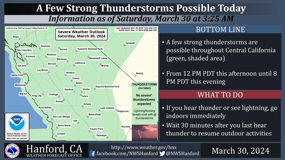
March 30, 2024 - National Weather Service Hanford Office officials report a few strong thunderstorms are possible throughout Central California from 12 PM PDT this afternoon until 8 PM PDT this evening.
Wind gusts near 45 miles per hour and small hail are a couple of hazards associated with strong thunderstorms.
In addition to dangerous cloud to ground lightning strikes, any thunderstorm can produce intense rainfall rates, leading to localized flooding.
Area Forecast Discussion
National Weather Service Hanford CA1218 AM PDT Sat Mar 30 2024
.KEY MESSAGES...
1. Major winter storm impacts in the Sierra Nevada above 5,000
feet this morning due to snow amounts up to two feet.
2. Travel will be very difficult in the Kern County mountains
above 5,000 feet today.
3. Excessive runoff from heavy rainfall in the Sierra Nevada
foothills this morning may result in rockslides in canyons and
steep hillsides.
4. Strong thunderstorms are possible across Central California
from 12 PM PDT this afternoon until 8 PM PDT this evening.
&&
.DISCUSSION...
An upper-level area of low pressure will move southward, just
off the coast of California, today and tonight. This cyclone
aloft should open up into a trough of low pressure and progress
eastward Sunday. The heaviest precipitation associated with this
atmospheric disturbance will fall this morning. Snow levels will
be around 5,000 feet today and tonight. Snow levels could drop
to about 4,000 feet Sunday morning. Winter Storm Warnings are in
effect for the Sierra Nevada and Kern County mountains above
5,000 feet. Here are probabilities of a foot or snow or more
for select locations in the Sierra Nevada today through Sunday:
Lake Wishon - 98%
Lodgepole - 96%
Huntington Lake - 94%
Shaver Lake - 90%
Badger Pass Ski Area - 83%
Strong thunderstorms are possible throughout Central California
this afternoon into this evening. A few strong thunderstorms are
conceivable in Kern County Sunday afternoon into Sunday
evening. The primary thunderstorm hazards will be dangerous
cloud to ground lightning strikes, small hail, wind gusts near
45 mph, and localized flooding.
A ridge of high pressure will build across the Golden State
early next week. This ridge of high pressure will progress
eastward Wednesday. A warming trend is expected Monday through
Wednesday. By Wednesday afternoon, high temperatures will be
seven to nine degrees above normal for this time of year. A
trough of low pressure will approach Central California. This
trough of low pressure may be responsible for periods of
precipitation Thursday afternoon into Friday.
&&
.AVIATION...
MVFR or lower conditions are possible in and near precipitation
this morning. IFR conditions are likely in and near
thunderstorms this afternoon into this evening. MVFR or lower
conditions are conceivable with mountain obscurations in the
Sierra Nevada and Kern County mountains tonight.
&&
.AIR QUALITY ISSUES...
None.
&&
.CERTAINTY...
The level of certainty for days 1 and 2 is medium.
The level of certainty for days 3 through 7 is medium.
Certainty levels include low, medium, and high. Please visit
www.weather.gov/hnx/certainty.html for additional information
and/or to provide feedback.
&&
.HNX WATCHES/WARNINGS/ADVISORIES...
Wind Advisory until 6 AM PDT Saturday for CAZ300-308-313.
Winter Storm Warning until 5 PM PDT Sunday for CAZ323-326>331.
Winter Storm Warning above 5000 feet until 5 PM PDT Sunday for
CAZ333-334.
Winter Storm Warning above 5000 feet until 11 PM PDT Sunday
for CAZ336.
Source: NWS
