


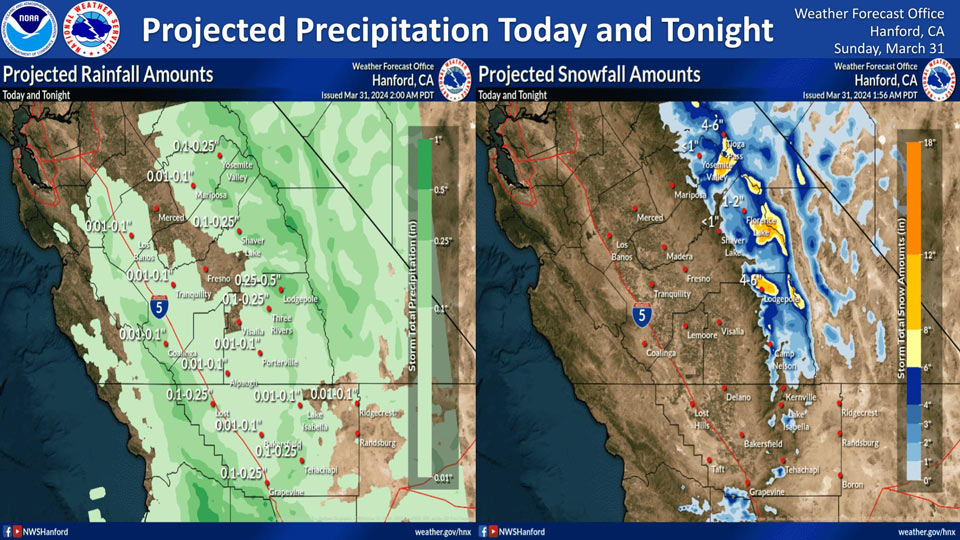
Projected rainfall for Mariposa: 0.01" to 0.10"
Projected rainfall for Yosemite Valley: 0.10" to 0.25"
March 31, 2024 - National Weather Service Hanford Office officials report precipitation associated with an exiting storm system will linger in Central California today and tonight. The majority of this precipitation will fall this afternoon and this evening.The snow level will start at around 4,000 feet this morning, before rising to around 5,000 feet this afternoon.
Area Forecast Discussion
National Weather Service Hanford CA
122 AM PDT Sun Mar 31 2024
.KEY MESSAGES...
1. Major winter storm impacts in the Sierra Nevada above 5,000
feet through this afternoon due to total snow amounts up to two
feet.
2. Travel will be very difficult in the Kern County mountains
above 5,000 feet through this evening.
3. Strong thunderstorms are possible across Central California
from 12 PM PDT this afternoon until 8 PM PDT this evening.
4. Temperatures will rise to above normal levels on Tuesday and
Wednesday.
5. Much cooler temperatures are expected later this week.
&&
.DISCUSSION...A large upper low off the Socal coast near
33N/123W continues to push moisture northward into central CA
and providing for scattered showers mainly south of Fresno
County. The proximity of the low to our area will provide for
enough instability today for isolated thunderstorms this
afternoon and evening across the West Side Hills and the Kern
County Mountains and Deserts with chances of showers continuing
through this evening across much of our area. With the snow
level expected between 5000 and 5500 feet today, the higher
elevations of the Sierra Nevada and Tehachapi Mountains will
have additional snow accumulations and Winter Storm Warnings will
continue through this afternoon.
The low is progged to continue moving southward to off the Baja
coast by tonight and move inland into northwestern Mexico by
Monday morning as high pressure builds inland into CA which will
result in daytime maximum temperatures rising to near normal
levels on Monday then above normal on Tuesday and Wednesday as
the high builds further inland and strengthens over central CA.
Here are the probabilities for Tuesday and Wednesday of PoE of
80 degrees.
TUE WED
Merced 2% 6%
Madera 2% 11%
Fresno 6% 51%
Lemoore 2% 26%
Hanford 2% 36%
Visalia 0% 26%
Bakersfield 2% 21%
Edwards AFB 0% 2%
China Lake NWTC 0% 71%
Ensemble means are showing another trough will deepen off the
CA on Thursday and then push inland on Friday which will result
in much cooler temperatures along with chances of precipitation.
NBM guidance is indicating that daytime temperatures will cool
down by around 20 DEG F between Wednesday and Friday. Shortwave
ridging will follow next Saturday and allow for some recovery in
temperatures.
&&
.AVIATION...In the San Joaquin Valley and Sierra Nevada
foothills, local MVFR in showers until 06Z Mon. In the West Side
Hills and Kern County Deserts, isolated thunderstorms until 03Z
Mon. Areas of MVFR in showers until 06Z Mon. In the Sierra
Nevada areas on MVFR in showers with local mountain obscuring
IFR. In the Tehachapi Mountains, isolated thunderstorms until
03Z Mon. Otherwise areas on MVFR in showers with local mountain
obscuring IFR.
&&
.AIR QUALITY ISSUES...None.
&&
.CERTAINTY...
The level of certainty for days 1 and 2 is medium.
The level of certainty for days 3 through 7 is medium.
Certainty levels include low...medium...and high. Please visit
www.weather.gov/hnx/certainty.html for additional information
and/or to provide feedback.
&&
.HNX WATCHES/WARNINGS/ADVISORIES...
Winter Storm Warning until 5 PM PDT this afternoon for CAZ323-
326>331.
Winter Storm Warning above 5000 feet until 5 PM PDT this
afternoon for CAZ333-334.
Winter Storm Warning above 5000 feet until 11 PM PDT this
evening for CAZ336.
Source: NWS
