


Includes Foothills of Fresno, Mariposa, Madera and Tuolumne Counties Including Yosemite
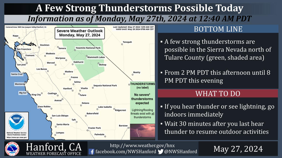
May 27, 2024 - National Weather Service Hanford Office officials report a few strong thunderstorms are possible in the Sierra Nevada north of Tulare County from 2 PM PDT this afternoon until 8 PM PDT this evening.
The primary thunderstorm hazards will be dangerous cloud to ground lightning strikes, small hail, and wind gusts near 45 mph.
Area Forecast Discussion
National Weather Service Hanford CA
329 AM PDT Mon May 27 2024
&&
.KEY MESSAGES...
1. There is a 15 to 25 percent chance for thunderstorms in the
Sierra Nevada Monday afternoon and evening.
2. A warming trend will result in afternoon maximums 3 to 7
degrees above normal beginning Monday and lasting through the
week.
3. There is a moderate (40 to 60 percent) probability for
temperatures to reach or exceed 95 degrees Friday and Saturday
in the San Joaquin Valley.
4. Gusty west winds are expected Tuesday through Friday for the
Mojave Desert Slopes and Kern County Desert.
&&
.DISCUSSION...
A relatively weak upper level ridging pattern is building over
central California this morning which will result in a warming
trend across the region today and Tuesday. Maximum afternoon
temperatures will be three to seven degrees warmer than average
for this time of year in the San Joaquin Valley and Kern County
Desert. The following are probabilities for select locations to
reach 90 degrees or higher this afternoon and tomorrow.
Monday
Fresno 71%
Visalia 61%
Bakersfield 56%
Delano 56%
Hanford 56%
Lemoore 56%
Porterville 46%
Madera 41%
Merced 31%
Reedley 26%
Tuesday
Delano 76%
Bakersfield 71%
Fresno 71%
Hanford 71%
Lemoore 71%
Visalia 71%
Porterville 66%
Madera 41%
Reedley 41%
Merced 26%
While the ridge propagates aloft, winds in the lower levels of
the atmosphere are projected to be from the west to southwest
this afternoon. Upsloping winds along the Sierra Nevada will
result in moisture convergence along the crests and the
opportunity for convective potential. National Blended Model
guidance expresses a 15 to 25 percent chance for thunder in
this area. Some stronger thunderstorms are possible, with the
greatest threat being dangerous cloud to ground lightning, small
hail, and wind gusts up to 45 miles per hour.
The aforementioned upper level ridge is projected to break down
late Tuesday into Wednesday as a trough begins to influence
central California while it passes through the Pacific Northwest
region. A slight cooldown will occur across our CWA as a
result, however maximum temperatures Wednesday afternoon are
projected to be one to three degrees above normal for this time
of year. The trough will also bring around stronger wind gusts
in the Kern County Desert and Mojave Desert Slopes on Wednesday
as NBM ensemble guidance suggests a moderate (50 to 60 percent)
probability for wind gusts 40 miles per hour or greater. Gusty
conditions are projected to continue each afternoon in this area
through the remainder of the week.
As the weekend approaches, cluster analysis continues to point
towards the development of another upper level ridge over the
Pacific coast. As a result, temperatures over central California
will warm above seasonal averages once again. Ensemble guidance
from the National Blended Model expresses a 40 to 70 percent
probability for temperatures to reach or exceed 95 degrees in
the San Joaquin Valley on both Friday and Saturday afternoon.
&&
.AVIATION...
VFR conditions will prevail across central California over the
next 24 hours.
&&
.AIR QUALITY ISSUES...
ISSUED: 05/26/2024 13:01
EXPIRES: 05/27/2024 23:59
None.
&&
.CERTAINTY...
The level of certainty for days 1 and 2 is medium.
The level of certainty for days 3 through 7 is medium.
Certainty levels include low...medium...and high. Please visit
www.weather.gov/hnx/certainty.html for additional information
and/or to provide feedback.
&&
.HNX WATCHES/WARNINGS/ADVISORIES...
None.
Source: NWS

