


California and National Drought Summary for June 4, 2024
Summary
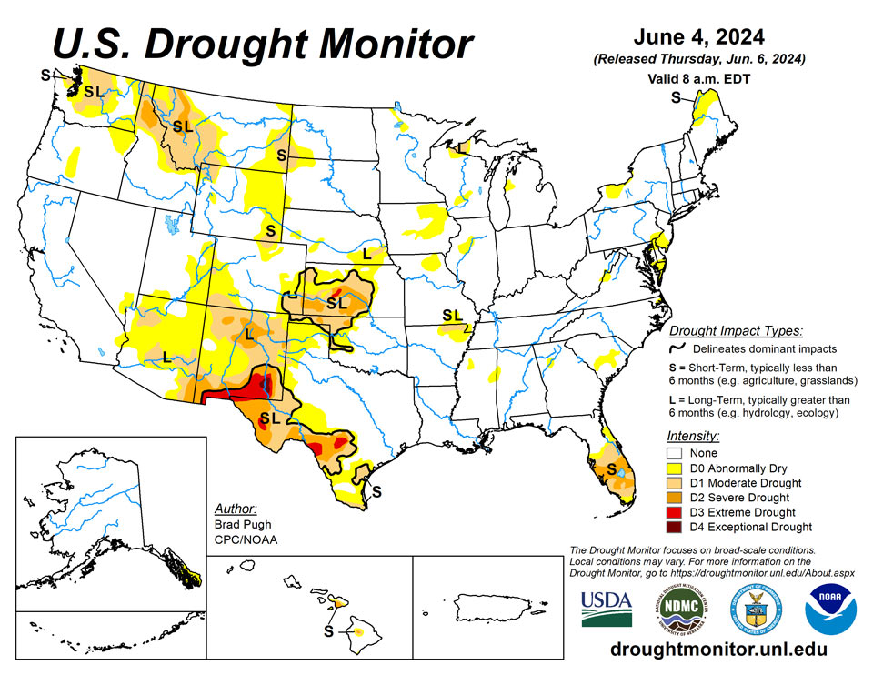
June 6, 2024 - Following a stormy pattern with frequent periods of heavy precipitation and severe weather outbreaks, major drought improvement occurred this spring across the Great Plains and Mississippi Valley. Recent heavy precipitation from May 28 to June 3 resulted in additional improvements to parts of the central and southern Great Plains. A dry start to the thunderstorm season and above-normal temperatures continued to result in drought expansion and intensification across the southern half of the Florida Peninsula. Anomalously heavy precipitation for late May into the beginning of June led to drought improvement across parts of Washington, northern Idaho, and western Montana. Alaska and Puerto Rico remain drought-free, while drought of varying intensity persists for parts of Maui and the Big Island of Hawaii.
Northeast
Abnormal dryness (D0) was expanded in Maine based on 30 to 60-day SPI, soil moisture, and 28-day streamflows. Groundwater at Lake Clayton along with the NDMC short-term blend supported the addition of moderate drought (D1) to northern Maine. 60-day precipitation deficits are 3 to 5 inches across northern Delaware, northeastern Maryland, and southeastern Pennsylvania where D0 was added this past week. The D0 coverage is also consistent with 30 to 60-day SPI and declining soil moisture indicators.
Southeast
Much of the Southeast remains drought-free after the wet winter and early spring related to El Nino. However, short-term drought continues to affect the southern half of the Florida Peninsula and excessive heat during May was a contributing factor to the worsening drought conditions. Based on 30-day SPEI and soil moisture, moderate (D1) to severe (D2) drought was expanded north across the Tampa Bay area. D2 was expanded eastward as well to the Atlantic coast side of south-central Florida where 90-day precipitation deficits exceed 6 inches, streamflows are low, and there is a recent increase in reported wildfires. A 1-category degradation was warranted for far southern areas of the Florida Peninsula. 60-day SPI from the Southern Regional Climate Center and declining soil moisture supported an expansion of D0 across the Coastal Plain of South Carolina. A small D0 area was added to the Atlanta area where 60-day precipitation deficits exceed 3 inches.
South
Widespread heavy precipitation (2 to 5 inches, locally more) this past week generally occurred outside of existing Dx areas of the South region. However, the heavy precipitation did overspread a few of the Dx areas. Heavy precipitation along with considerations of NDMC drought blends supported a 1-category improvement to parts of northwestern Oklahoma, Texas Panhandle, and south-central Texas. Also, a slight reduction in abnormal dryness (D0) was warranted for northeastern Arkansas and western Tennessee. 30 to 60-day SPEI and soil moisture indicators led to a 1-category degradation to parts of southern Texas and the middle Rio Grande Valley. Maximum temperatures have averaged 4 to 8 degrees F above normal during the past two weeks across the middle to lower Rio Grande Valley which is likely drying out topsoil and a factor in worsening drought conditions.
Midwest
A very wet spring has resulted in nearly all of the Midwest becoming drought-free. Much of Iowa, southern Minnesota, and southern Wisconsin have received more than 15 inches of precipitation during the past 90 days. Additional precipitation this past week led to a continued decrease in the coverage of abnormal dryness (DO) and moderate drought (D1) across Minnesota and Wisconsin. Only a small area of long-term D1 is now designated for portions of northern Wisconsin and the Upper Peninsula of Michigan. The one exception to the spring wetness are small areas of northwestern Illinois and northern Missouri where 30-day precipitation deficits are increasing and soil moisture is beginning to decline.
High Plains
Widespread heavy precipitation (1 to 3 inches, locally more) resulted in a 1-category improvement to parts of Kansas, eastern Colorado, and southeastern Nebraska. A small area of long-term D1 was maintained for southeastern Nebraska that received less than 1 inch of precipitation this past week and a long-term drought signal continues. Based on neutral or wet soil moisture percentiles and NDMC drought blends, a 1-category improvement was made to northwestern North Dakota where more than 1 inch of precipitation occurred this past week. 30 to 60-day SPI and soil moisture indicators supported an expansion of abnormal dryness (D0) and moderate drought (D1) for northern Colorado and southeastern Wyoming
West
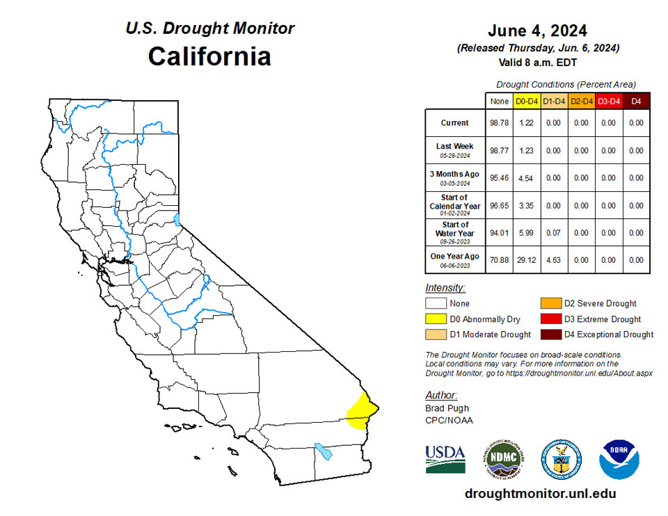
The climatology becomes much drier during May through the beginning of June across California, the Great Basin, and Southwest. There was little to no change in Dx coverage throughout these areas. Heavy precipitation (1.5 inches or more) this past week supported a 1-category improvement to parts of northeastern New Mexico. Recent precipitation with a relatively cool late spring and SPIs at multiple time scales resulted in a 1-category improvement to western Montana and adjacent areas of northern Idaho. Unusually heavy precipitation (locally more than 3 inches) for the late spring led to a decrease in abnormal dryness (D0) and moderate drought (D1) coverage across parts of Washington. However, much of the existing moderate drought area of north-central Washington remained unchanged with precipitation averaging less than 50 percent of normal since October 1, 2023.
Caribbean
Much of Puerto Rico received more than 2 inches of rainfall this past week and it remains drought-free.
The U.S. Virgin Islands remained free of drought or abnormal dryness this week. Drier weather prevailed on St. John this week, with measured rain amounts of 0.29 and 0.44 inches, but short- and long-term rainfall anomalies are in the normal-to-wet range. St. Thomas CoCoRaHs observers measured rain amounts of 0.94 and 1.45 inches. Groundwater depth dropped about a foot this week, though it is still high compared to mid-April and last summer’s lows. Rainfall amounts on St. Croix varied widely, ranging from 0.85 to 2.44 inches. Short- and long-term rainfall anomalies are near or above normal at East Hill, while groundwater depth values remained near 23 feet—much higher than early spring and before.
Pacific
Despite an increasingly wet pattern for southern Southeastern Alaska during May and into the beginning of June, no changes were made to the abnormal dryness (D0) area due to continued precipitation deficits dating back to January.
Although southern Maui and central portions of the Big Island remain quite dry, May rainfall and condition reports supported improvements to the southwest corner of Maui and northern areas of the Big Island.
Very wet weather prevailed this week in American Samoa, and they remained free of any dryness. Measured weekly rainfall totals ranged from 5.13 inches at Pago Pago to 10.4 and 11.61 inches at Toa and Siufaga Ridges, respectively.
Rain this week totaled 0.48 inches at Koror and 0.86 at Palau airport. Despite 4.75 inches at Koror last week, short-term abnormal dryness continued due to this week’s drier weather combined with May finishing below 8 inches of rainfall (which is also well below normal for May).
After rain amounts ranged from 2.1 to 3.55 inches last week on Guam, lighter rainfall amounts this week ranged from 0.24 to 0.51 inches. Given mostly very dry weeks over the last several months, severe short-term drought continued this week. Extreme short-term drought continued on Rota and Saipan, where 0.18 and 0.7 inches of rainfall were recorded this week.
Extreme short- and long-term drought continued this week on Yap and Ulithi, where 0.38 and 1.49 inches of rain were recorded, respectively. Woleai improved to moderate short- and long-term drought after 2.71 inches of rain this week followed 5.43 inches last week. No data were reported for Fananu so no Drought Monitor depiction was made there. Chuuk and Lukunor remained free of any dryness after 1.68 and 4.85 inches of rain were reported. Nukuoro and Kapingamarangi were also free of dryness; rainfall totaled 1.44 and 1.07 on these islands. Wet weather continued on Pohnpei this week where 2.38 inches of rain followed last week’s deluge of 9.62 inches. Pingelap received 4 inches of rain this week after 2.98 inches fell last week. Despite recent missing data before that, the wet couple of weeks resulted in a drought- and dryness-free Drought Monitor depiction for this week. Kosrae reported limited data this week, though wet weather stretching back to January kept their Drought Monitor depiction dryness-free for this week.
Long-term abnormal dryness continued this week on Kwajalein, where 3.74 inches of rain fell this week. Ailinglapalap and Jaluit remained free of dryness this week, where 3.5 and 3.33 inches of rain fell. Wotje had a dry week and remained in short- and long-term moderate drought. Majuro remained free of dryness with 1.25 inches of rain this week. While this was the second consecutive week with less than 2 inches of rainfall, May rainfall totaled over 1.5 times their normal amount for the month with 15.39 inches. No data were reported for Utirik or Mili this week, so no Drought Monitor depictions were made there.
Looking Ahead
During the next five days (June 6-10, 2024), multiple cold fronts are forecast to progress across the eastern and central contiguous U.S. The heaviest precipitation (more than 1 inch) is forecast for the Northeast, Tennessee Valley, and Ozarks region. Locally heavy rainfall may accompany thunderstorms across the central to southern Great Plains. Dry weather, typical for this time of year, is forecast for the Southwest, California, and the Pacific Northwest. A heat wave will affect the Southwest and Central Valley of California during early June.
The Climate Prediction Center’s 6-10 day outlook (valid June 11-15, 2024) favors above-normal temperatures across most of the West, Great Plains, New England, and Florida. Below-normal temperatures are most likely for the Ohio and Tennessee Valleys and central to southern Appalachians. Below-normal precipitation probabilities are slightly elevated for much of the Corn Belt, Mississippi Valley, and Pacific Northwest. Above-normal precipitation is favored for the central to southern Rockies and high Plains along with the coastal Southeast and Florida
Author(s):
Brad Pugh, NOAA/CPC
Curtis Riganti, National Drought Mitigation Center
Dryness Categories
D0 Abnormally Dry—used for areas showing dryness but not yet in drought, or for areas recovering from drought.
Drought Intensity Categories
D1 Moderate Drought
D2 Severe Drought
D3 Extreme Drought
D4 Exceptional Drought
Drought or Dryness Types
S Short-term, typically less than 6 months (agriculture, grasslands)
L Long-term, typically more than 6 months (hydrology, ecology)
SL Area contains both short- and long-term impacts
Source: National Drought Mitigation Center

