


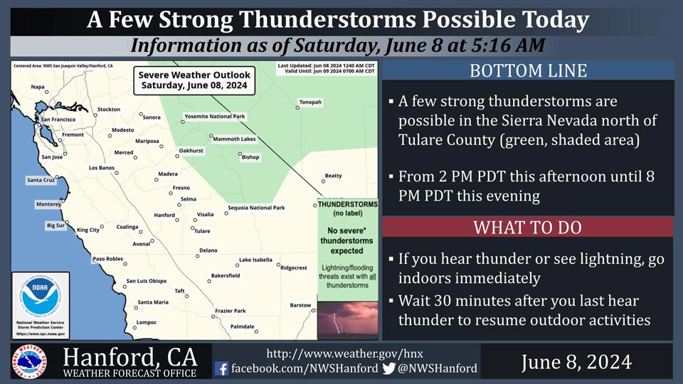
Includes Eastern Fresno, Madera, Mariposa and Tulare Counties, also Yosemite National Park
June 8, 2024 - National Weather Service Hanford Office officials report a few strong thunderstorms are possible today along the Sierra Nevada crest north of Tulare County this afternoon.
The greatest probabilities for thunderstorms today (10-20%) are in Tulare and Fresno Counties.
Area Forecast Discussion
National Weather Service Hanford CA
125 AM PDT Sat Jun 8 2024
.KEY MESSAGES...
1. Temperatures will lower this weekend, but are forecast to
still be around 3 to 6 degrees above normal by Sunday.
2. Another round of triple digit heat is forecast by the middle
of next week, with probabilities of afternoon highs exceeding
100 degrees in the San Joaquin Valley between 50 and 75 percent
on Tuesday and Wednesday.
3. The warm temperatures will allow increased snowmelt to
continue over the Sierra Nevada, resulting in colder and higher
flows along rivers and waterways.
&&
.DISCUSSION...
For today, most areas will get a brief break from the triple
digit heat, at least in the San Joaquin Valley. However, some
valley locations still have about a 20 to 40 percent chance to
reach 98 degrees today. The desert locations have a similar
chance for highs at least 100 degrees, except triple digit heat
remains nearly certain (90-100 percent chance) in the Indian
Wells Valley this afternoon. Due to the flow of marine air
through the passes, some locally gusty winds are occurring
overnight towards the coastal ranges, such as Pacheco Pass, with
gusts around 30 to 40 mph. High resolution guidance suggests a
recurrence of breezy conditions this afternoon and evening,
though with gusts around 30 mph. A slight (10 to 20 percent)
chance continues for isolated thunderstorms this afternoon for
locations along the Sierra Nevada crest, mainly in Fresno and
Tulare Counties.
The trend of lowering temperatures continues into Sunday. Lower
probabilities are shown for Sunday regarding highs in the upper
90's in the Central Valley and triple digits in the Kern County
desert, except the Indian Wells Valley still has about a 70
percent chance. Monday will be similar to Sunday in terms of
high temperatures, although the chances of a high at least 95
degrees (roughly 5 degrees above seasonal averages) are around
20 to 40 percent on Sunday and 35 to 55 percent on Monday. In
short, it will be a noticeable change in temperatures, although
slightly above average highs will prevail.
The upper-level ridge rebuilds by midweek. The potential for
widespread triple digit heat begins Tuesday and will last into
Wednesday. For both days, the probabilities have increased to
about 50-75 percent chance throughout the San Joaquin Valley.
Also, the chances for another 105 degree reading are 20-40
percent in the SJ Valley for Wednesday and up to 20 percent on
Tuesday. Highs at or above 105 degrees have a much greater
chance (60-80 percent) of occurrence in Ridgecrest/China Lake
for both days. So, while it may not be as hot as Thursday's
observed temperatures, it will be close. At this time,
moderating temperatures are generally projected for Friday and
next weekend, or similar temperatures to this coming Sunday and
Monday. With this scenario, we will have to monitor for another
increase in winds in the typical prone areas.
Snowmelt will continue in the Sierra Nevada into next week with
an increase during midweek due to the anticipated heat. Unfortunately,
the threat of dangerously cold, fast moving water in rivers and
waterways will remain for the period.
&&
.AVIATION...
VFR conditions will prevail across the Central CA
interior for the next 24 hours.
&&
.AIR QUALITY ISSUES...
None.
&&
.CERTAINTY...
The level of certainty for days 1 and 2 is high.
The level of certainty for days 3 through 7 is medium.
Certainty levels include low...medium...and high. Please visit
www.weather.gov/hnx/certainty.html for additional information
and/or to provide feedback.
&&
.HNX WATCHES/WARNINGS/ADVISORIES...
None.
Source: NWS

