


California and National Drought Summary for June 11, 2024
Summary
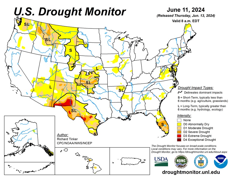
June 13, 2024 - A highly variable precipitation pattern was noted across the contiguous 48 states this past week, resulting in a significant number of changes in the Drought Monitor depiction. Another week of heavy rain June 4-11 continued to ease drought and abnormal dryness in parts of the central and southern Plains, with excessive amounts resulting in 2-category improvements in portions of central Kansas. Moderate to heavy rainfall also brought improvements to portions of the middle and upper Mississippi Valley, the Northeast, the Washington Cascades, and southernmost Florida. Meanwhile, deficient rainfall caused abnormal dryness and drought to expand or intensify in parts of southern New England, the mid-Atlantic region, the interior Southeast, the central and northern Florida Peninsula, a few scattered areas across Texas, part of the central Rockies, the northern High Plains, some sections of interior Washington and Oregon, and a small region in northeastern Alaska. Other areas were unchanged, including Hawaii and Puerto Rico
Northeast
Moderate to locally heavy rainfall reduced the coverage of abnormal dryness (D0) in western New York and across northern and western Maine. Residual areas of abnormal dryness remain where 30- to 60-day rainfall shortages persisted in western New York, and where similar shortages or deficient groundwater was observed in Maine. Farther south, locally heavy thunderstorms in southeastern Pennsylvania and adjacent southwestern New Jersey ended abnormal dryness in those areas. In contrast, subnormal rainfall over the past few weeks led to the introduction of D0 conditions in northwestern Massachusetts, and in a swath across much of Delaware and central Maryland. D0 conditions were unchanged in other parts of southeastern Pennsylvania, southern New Jersey, and eastern West Virginia while the vast majority of the region remained out of dryness and drought, although some developing pockets of dryness will need to be monitored over the next few weeks.
Southeast
Dryness and drought (D0 to D2) continued to affect the Florida Peninsula, spreading northward this past week. Light rainfall and increased short-term moisture deficits engendered worsening conditions over much of the central and northern Florida Peninsula, along with a few patches near the southeast and southwest Florida coasts. Farther inland across southern Florida, rainfall totals of 3 to locally 5 inches doused a few areas, prompting a few swaths of improvement, generally from D2 to D1, to the southwest and southeast of Lake Okeechobee. Farther north, drought is absent from the Southeast Region from the northern tier of Florida northward through Alabama and the South Atlantic States through Virginia, but several areas of D0 expanded this week. The largest new area of abnormal dryness was identified across a large portion of northern and western Virginia. The northern tier of this area has recorded 25 to 66 percent of normal precipitation during the past 30 days, or 1-2 inches below normal. 30-day totals are slightly larger in southwestern Virginia, but 60-day amounts of 3-6 inches below normal are widespread. D0 conditions, based primarily on 30- to 90-day precipitation deficits and reflections of surface moisture shortages, also persisted or expanded through southeastern Virginia, parts of the Outer Banks, southeastern North Carolina, interior east-central South Carolina, part of northwestern Georgia (including much of the Atlanta metro area) and adjacent Alabama, and a small part of northwest Alabama. .
South
Widespread dryness and drought continued to cover western Oklahoma, the western Texas Panhandle, and most other areas across southern and western Texas. Rainfall totals were generally unremarkable across western Oklahoma, keeping D0 to D2 conditions generally unchanged, save for a couple of small patches near the central part of the state. In contrast, rainfall was highly variable in the areas of Texas that have been affected by dryness and drought (D0 to D3) recently, leading to sizeable areas that felt both deterioration and improvement. Most of the dry areas in the Texas Panhandle received at least moderate rain last week (1.5 inches or more), with several patches soaked by 3 to 5 inches of rain. As a result, improvement was introduced in many locations across this region. Farther south, moderate to locally heavy rains were observed in portions of the southern Edwards Plateau and southward through parts of Bandera, Medina, and Bexar Counties. Totals of 1-2 inches were fairly common in this region, although a few swaths received more, up to 4 inches at a few isolated locations. Improvement was also introduced in significant parts of this region, although less broadly than farther north since heavier totals were not as widespread. In sharp contrast, dry and hot weather across Deep South Texas and western parts of the Edwards Plateau led to broad-scale deterioration in these regions. Agricultural interests in the western Edwards Plateau report slowed planting due to quickly depleting surface moisture, resulting in blowing sand and dirt with little or no soil moisture. Over the past 90 days, a broad area from the southern Big Bend southward along the Rio Grande Valley into Maverick County recorded only 10 to 50 percent of normal rainfall, with similar amounts reported across portions of the western Edwards Plateau. The remainder of the South region is nearly free of notable dryness. Moderate drought is restricted to a couple of patches in northeastern Arkansas, with abnormal dryness covering the remainder of northeastern Arkansas and a large part of northern Mississippi. Moderate rains brought limited improvement to portions of northeastern Arkansas this past week, but only light rains fell across northern Mississippi, increasing short-term moisture deficits and prompting an increase in D0 coverage. Northwestern Mississippi has recorded near or just over one-half of normal rainfall since mid-April.
Midwest
A warm and wet spring eliminated much of the drought that had plagued western parts of this region, and with moderate to heavy rains in northern and southwestern parts of the Midwest last week, the last area of drought (D1 in the northwestern Upper Peninsula of Michigan) was removed from the map. The wet weather also removed D0 from northern Minnesota, northern Wisconsin, western Michigan, part of central and northeastern Iowa, and southern Mississippi. Meanwhile, rainfall has not been so generous the past few weeks over west-central parts of the Region, prompting some expansion of D0 conditions across northeastern Missouri, northwestern Illinois, and part of east-central Illinois. Short-term moisture deficits are increasing in other nearby locations as well, most notably portions of Indiana and southeastern Iowa, and these areas will need to be monitored for the development of abnormal dryness in the next few weeks.
High Plains
Parts of the southern High Plains Region were hit by heavy to excessive rains, bringing widespread improvement to the entrenched dryness and drought affecting much of Kansas and eastern Colorado. The heaviest amounts soaked a swath across central Kansas, with more scattered heavy rains observed farther north in Kansas and across eastern Colorado. Between 5 and 8 inches fell on central Rice, eastern McPherson, central Marion, and much of Chase Counties in central Kansas, prompting some 2-category improvements there. D3 conditions were eliminated from the High Plains Region, and severe drought (D2) is now limited to a few several-county south and west of the band where the heaviest rains fell last week. Moderate rains (over 1.5 inch) reached into southern Nebraska as well, improving conditions in southeastern Nebraska. Farther north and west, conditions were considerably drier, and most sites recorded several tenths of an inch of rain at best. This kept conditions essentially unchanged in most areas, although some D0 expansion was introduced in north-central Colorado, western Nebraska and adjacent South Dakota, and north-central South Dakota. A dry week also allowed conditions to deteriorate in part of southwestern Colorado, with moderate drought (D1) expanding northward into west-central Colorado. There was an additional, small area of improvement in part of Laramie County in southeastern Wyoming, where a mesoscale heavy rain event (2.0 to 4.5 inches) eased D0 to D1 conditions.
West
Similar to western Texas, moderate to heavy precipitation also doused much of eastern New Mexico last week, inducing widespread 1-category improvement. The heaviest amounts (4.5 to locally 8.0 inches) fell on southern and west-central Guadalupe County, but most of the eastern half of the state reported at least 0.5 inch. Another area that experienced some drought relief was the higher elevations of the Cascades in Washington. During the past 30 days, 8 to 15 inches of precipitation has fallen on the peaks, with the largest totals observed in Snohomish County. Another 0.5 to 2.0 inches fell along and just east of the highest elevations last week. As a result, moderate drought was reduced to abnormal dryness there. However, across the northern tier of the region to the south and east of the Washington Cascades, persistently below-normal precipitation in many areas led to the expansion of abnormal dryness (D0) and moderate drought (D1) in a few areas, in particular the north-central Oregon Cascades, part of interior southeastern Oregon, part of the central and eastern Washington plains, and a broad area of northern and central Montana from east of the Rockies to near North Dakota. Soil moisture and some streamflows have begun to reflect the past few weeks of subnormal rainfall across portions of central and eastern Montana.
Caribbean
Moderate to heavy rain fell on portions of northern and eastern Puerto Rico, with isolated locations observing 3 to 5 inches, but most sites across the island reported a several tenths of an inch or less, with generally dry conditions during the last few days of the period. Due to the wet pattern of the last few months, however, no dryness or drought is affecting the Coimmonwealth.
The U.S. Virgin Islands remained free of drought or abnormal dryness this week. On St. Thomas, a CoCoRaHs observation site on the west end of the island reported 1.35 inches of rain between June 5 and 10. Well water height from St. Thomas was relatively high on June 11, sitting at about 2.7 feet below ground level. On St. John, the observer at Windswept Beach reported 3.8 inches of rain this week, and substantial rainfall surpluses currently exist on most time scales out to a year. On St. Croix, rainfall amounts ranged from 1.24 to 2.14 inches.
Pacific
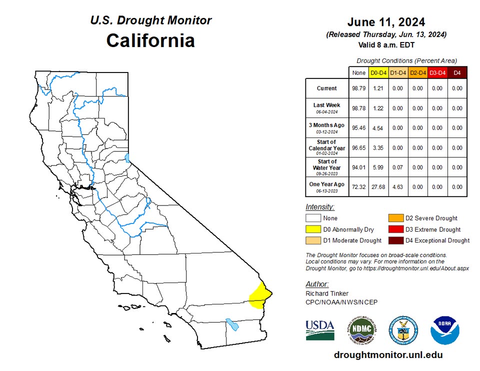
Precipitation was unremarkable during the past week, and while near to above normal precipitation was observed during the prior few weeks, no changes were made to the abnormally dry (D0) area due to precipitation deficits dating back to January. Farther north, surface moisture has been declining in portions of the Yukon Flats, bringing a notable increase in surface dryness and fire danger indicators, so abnormal dryness has been introduced in this region.
Dryness and drought categorizations were unchanged following a week of near to below normal precipitation.
Drier weather occurred this week at Pago Pago with only 0.57 inches of rain, but wet weather continued at Toa and Siufaga Ridges, with 6.39 and 4.54 inches of rain, respectively. American Samoa remained free of drought or abnormal dryness for the week.
Short-term abnormal dryness was removed this week from Palau, where 5.31 inches of rain were measured at Airai and 5.97 inches were measured at Koror.
Short- and long-term extreme drought continued on Yap and Ulithi this week, though 2.16 and 2.74 inches of rain fell on the islands, respectively. This has likely helped short-term conditions to improve a bit and further analysis will be done next week. Woleai received 0.86 inches of rain this week, a bit drier than the preceding few weeks, and moderate short- and long-term drought continued there. No Drought Monitor depiction was made for Fananu or Kosrae, as the data are fully missing from Fananu and insufficient from Kosrae to make a depiction. The rest of the Federated States of Micronesia remained free of drought or abnormal dryness this week. Rainfall totaled 1.81 inches at Chuuk, continuing a recent drier stretch that has not yet developed into abnormal dryness. Lukunor only recorded 0.66 inches of rain, though 3 days were not accounted for this week. Nukuoro recorded 0.99 inches of rain this week, marking the second consecutive week with less than 2 inches of rain. Kapingamarangi also continued a recent drier trend, recording only 1.55 inches of rain this week. Pohnpei recorded 2.19 inches of rain, while Pingelap was a little drier, receiving 1.37 inches this week after last week’s 4 inches.
Conditions on Saipan improved to short-term severe drought, after rain totaled 1.83 inches at the international airport weather station and 3.02 inches at the National Park Service site. Rota remained in short-term extreme drought after 0.98 inches of rain this week. Guam improved to short-term moderate drought after this week’s rainfall measurements ranged from 1.83 to 2.25 inches.
Kwajalein remained in long-term abnormal dryness after 0.34 inches of rain were reported this week. Ailinglapalap and Jaluit remained free of drought or abnormal dryness after 2.47 and 0.8 inches of rain fell, respectively. Short- and long-term moderate drought continued on Wotje after 0.33 inches of rain were reported this week. A recent dry stretch continued on Majuro with 1.04 inches of rain falling this week. However, given May’s 15.39 inch rainfall total, which sits in the 83rd percentile for the month, short-term abnormal dryness has not yet developed on Majuro. No Drought Monitor depictions were made for Mili or Utirik, as data were unavailable in both locations.
Looking Ahead
During the next five days (June 13-17, 2024), tropical moisture is expected to interact with mid-level low pressure across southern Florida, resulting in heavy rain. Flood watches are currently in effect, and 3 to 5 inches of rain are expected before precipitation tapers off later in the period. Tropical moisture from the Gulf of Mexico may also push into the central Gulf Coast region, bringing 1.5 to 2.5 inches of rain to the Louisiana Bayou and southern Mississippi. Farther north, thunderstorms along a frontal boundary are expected to drop 1.5 to 3.5 inches of rain on parts of the northeastern Great Plains and Upper Mississippi Valley. Moderate precipitation is expected in other parts of the northern Great Plains, upper and middle Mississippi Valley, western Great Lakes region, eastern New England, northern Florida Peninsula, southern lower Mississippi Valley, and higher elevations of the northern Rockies and Cascades. Meanwhile, the summer’s first extended period of excessive heat is forecast to develop toward the end of the period in the central Great Plains, expanding eastward across the middle and upper Mississippi Valley, the Ohio Valley, the mid-Atlantic region, and the Northeast by the end of the period. Highs well into the 90s should be widespread by the end of the period, and warm nighttime lows are expected, providing little relief. Subnormal temperatures are forecast to be limited to the Pacific Northwest.
The Climate Prediction Center’s 6-10 day outlook (valid June 18-22, 2024) favors above-normal temperatures from the southern Rockies and most of the Plains eastward to the Atlantic Ocean, with the most prohibitive odds (over 80 percent) across the Northeast and New England away from the immediate Atlantic Coast. There is a good chance that excessive heat will continue through at least part of the period across central and northern parts of the U.S. from the Mississippi Valley eastward. Farther west, subnormal temperatures are favored in many areas, but only slightly, with odds remaining below 40 percent (climatological odds are 33 percent). Below-normal precipitation is favored across the mid-Atlantic region, the Carolinas, the upper Southeast, and the Ohio Valley, as well as southeastern Alaska. However, odds tilt toward above-normal precipitation over a larger area encompassing the Gulf Coast region, the northern and southern Great Plains, the High Plains, the Great Lakes Region, the southern Rockies, the northern tier of the contiguous U.S. from the northern Rockies to the Pacific Coast, northeastern Alaska, and Hawaii. The best chances for surplus rainfall (50 to 70 percent) cover southern Texas.
Author(s):
Richard Tinker, NOAA/NWS/NCEP/CPC
Curtis Riganti, National Drought Mitigation Center
Dryness Categories
D0 Abnormally Dry—used for areas showing dryness but not yet in drought, or for areas recovering from drought.
Drought Intensity Categories
D1 Moderate Drought
D2 Severe Drought
D3 Extreme Drought
D4 Exceptional Drought
Drought or Dryness Types
S Short-term, typically less than 6 months (agriculture, grasslands)
L Long-term, typically more than 6 months (hydrology, ecology)
SL Area contains both short- and long-term impacts
Source: National Drought Mitigation Center
