Monday, July 1, 2024 Update:
Sierra National Forest Basin Fire Update for Monday, July 1, 2024: 0% Containment at 12,631 Acres – Includes Public Information Map
June 30, 2024 - A lightning Storm passed through the High Sierra Ranger District on June 24th on the Sierra National Forest and 18 wildfires resulted. Fire crews have successfully contained 17 out of the 18 from the lightning storm.
The only fire remaining is the Basin Fire, which is currently 9,549 acres, 0% contained. It is burning in a mix of grass, light brush, and oak hardwoods.
| Current as of | Sun, 06/30/2024 - 09:44 |
|---|---|
| Incident Time Zone | America/Los_Angeles |
| Incident Type | Wildfire |
| Cause | Under Investigation. |
| Date of Origin | Wed, 06/26/2024 - 22:29 |
| Location | East of Pine Flat Reservoir, 46 miles East of Sanger |
| Incident Commander | California Incident Management Team 11 assumed command of the Basin Fire at 7:00 on June 28th. |
| Incident Description | The Basin Wildfire is burning in grass, chapparal and oak timber. It is also burning in steep terrain. |
| Coordinates | 36° 51' 52'' Latitude -119° 6' 9
'' Longitude |
| Total Personnel: | 697 |
|---|---|
| Size | 9,549 Acres |
| Percent of Perimeter Contained | 0% |
| Fuels Involved |
Tall Grass, Brush, and Hardwood (Oak) Litter. |
| Significant Events |
Active |
| Planned Actions |
Evacuation of any additional public in the area of the fire, suppression activities continuing, taking advantage of existing roads, rivers, barriers. Limit fire growth by using direct and indirect attack methods utilizing nearby ridge's, roads, and rivers with crews and aerial operations or other containment line locations which provide the highest likelihood of success while minimizing hazard exposure to firefighters |
|---|
| Weather Concerns |
Warm and dry conditions over the weekend will transitions to hot and dry condition's next week under building high pressure that will result in temperatures 10-15 degrees above average by midweek. RH minimums in the upper teens will trend drier next week as well and lead to an extended period of hot and dry weather over the 4th of July holiday period. |
|---|
Current Situation:
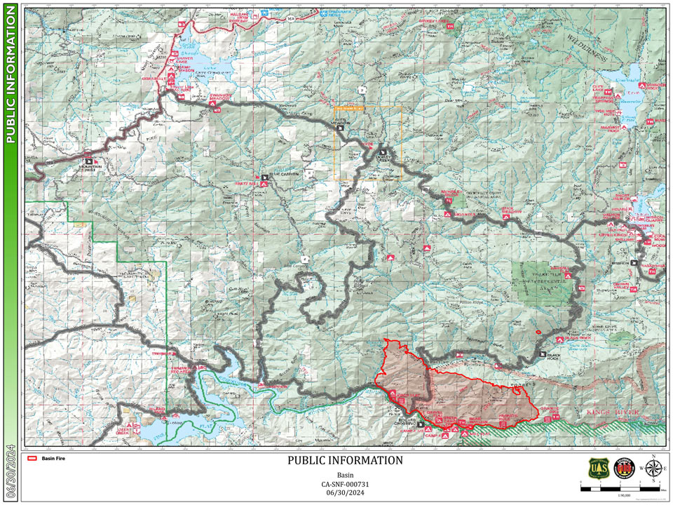
The Basin Fire is 9,549 acres with 0% containment. The fire started on Wednesday, June 26th. The cause is currently under investigation. It is on the High Sierra Ranger District of the Sierra National Forest. It is northeast of Pine Flat Lake, west of Spanish Mountain, south of Black Rock Rd (11S012) and north of the South Fork of Kings River.
The main fuels are grass and brush. The grass is dead, dried and very dense after two years of significant rainfall across California. This fuel type has been surprisingly resistant to control on this fire, as a result of its very thick and dense base.
Fire crews are working diligently to hold the fire north of the South Fork of the Kings River; this is the current southern fire perimeter. The northern fire perimeter is holding along Rodger’s Ridge and crews are building and improving fire-line to hold the fire along this ridge. Structure protection crews have been deployed to protect energy infrastructure at Balch Camp, at the confluence of Dinky Creek and the North Fork of the Kings River. Bulldozers are building a fire break to the west/northwest of the fire, a remote area with potential for moderate fire growth. It is this northwestern fire perimeter area that has the greatest potential for growth. Crews have been able to build some direct line on the eastern fire perimeter but are also looking for opportunities to build indirect line as well. Additional personnel and equipment have been ordered to the Basin Fire and are arriving daily.
Winds should remain light today, with temperatures at the fire of 85-90 and minimum relative humidity of 15-18%. A heat wave forecast for July 2-6 will bring challenging temperatures of near 100 at the fire with low humidity.
NEW Temporary Partial Forest Closure Order for the Basin Fire: To ensure the safety of the public and our firefighters, The Sierra National Forest has issued a Forest Closure for the Basin Fire area. Effective June 30, 2024, the closure will remain in effect until July 30, 2024. We urge the public to respect all closure signs and barriers and to avoid the area to prevent any potential accidents or interference with firefighting efforts. Please visit https://www.fs.usda.gov/sierra for the forest order and area map.
Forest Visitors: this may impact your Fourth of July holiday plans! You will not be able to visit the campgrounds and trails within the closure area. Please support our firefighters and stay out of this area.
There is a mandatory evacuation order for the following Fresno County zones: KK30, K29, K73 north and K75 south of Elwood.
There is an evacuation warning for these Fresno County zones: K72, K73 south, K75 north of Elwood, K 93 and K 134..
Please check the Fresno County Evacuation map: https://www.arcgis.com/apps/webappviewer/index.html?id=e7d6006a016a444db8b210ac4d2eb5cf
Closures:
Road closure signs have been placed on the perimeter of the fire. The public should review which roads are closed before traveling into the area because no one will be allowed to enter zones under evacuation warnings. To access websites showing both evacuation orders, road closures and many other emergency resources, visit: http://www.fresnocountyemergency.com
Smoke - Visit AirNow to find out the Air Quality Index in your area. As smoke gets worse, the amount of particles in the air changes - and so do the steps you should take to protect yourself. AirNow recommends precautions you can take to protect your health when air pollution gets bad
Click here for full size map
Public Information Map for Sunday