


Tuesday, July 2, 2024 Update:
Sierra National Forest Basin Fire Update for Tuesday, July 2, 2024: 17% Containment at 13,166 Acres – Includes Public Information Map
July 1, 2024 - The Basin Fire northeast of Fresno is currently at 12,631 acres and 0% containment. The fire is burning primarily in dry, dense grass within the Rough Fire scar from 2015.
| Current as of | Mon, 07/01/2024 - 09:32 |
|---|---|
| Incident Time Zone | America/Los_Angeles |
| Incident Type | Wildfire |
| Cause | Under Investigation. |
| Date of Origin | Wed, 06/26/2024 - 22:29 |
| Location | East of Pine Flat Reservoir, 46 miles East of Sanger |
| Incident Commander | California Incident Management Team 11 assumed command of the Basin Fire at 7:00 on June 28th. |
| Incident Description | The Basin Wildfire is burning in grass, chapparal and oak timber. It is also burning in steep terrain. |
| Coordinates | 36° 51' 52'' Latitude -119° 6' 9
'' Longitude |
| Total Personnel: | 879 |
|---|---|
| Size | 12,631 Acres |
| Percent of Perimeter Contained | 0% |
| Fuels Involved |
Tall Grass, Brush, and Hardwood (Oak) Litter. Tall grass is predominant, with some hardwood. Live fuel moisture is near average. 1000 hour fuels (larger trees) are above average and Energy Release Component (ERC's) are below average for the time of year. |
| Significant Events |
Active with Uphill Runs and Short-range Spotting. Continued growth to the western and northwest portion of the fire. Moderate to large areas of intense |
| Planned Actions |
This fire is a full suppression fire. The current strategy of using tactical ridges and indirect line reduces |
|---|---|
| Projected Incident Activity |
12 Hours: Diurnal winds will push the fire to the west and east of the Kings River. These winds will also have the potential to influence fire movement in the North Fork of the Kings River toward Dinky Creek near Balch Camp. |
| Weather Concerns |
Warm and dry conditions will continue today before a long duration heat wave begins early next week. Expect temperatures today 5-7 degrees above average with RH minimums near 20%. Temperatures will gradually rise thru next week and bring triple digit heat to the lower elevations of the fire by mid-week. Diurnal winds will prevail over the fire for the next several days. Excessive Heat Warning in effect from Tuesday 7/2 Mon 7/8. |
|---|
Current Situation: The Basin Fire northeast of Fresno is currently at 12,631 acres and 0% containment. The fire is burning primarily in dry, dense grass within the Rough Fire scar from 2015. While there was some growth along the northwest and eastern edges of the fire yesterday, the rate of growth is slowing. Additional personnel and equipment are continuing to arrive daily to support firefighting operations on the Basin Fire. Crews are improving roads east of Sacate Ridge to gain access to the northwest corner of the fire, which will be the highest priority for aircraft support today. Structure protection crews are working in the Balch Camp area to protect energy infrastructure, and bulldozers are continuing their work constructing a fuel break to the west and northwest of the fire. Hot shot crews will be inserted on the northern edge of the fire near Rodger’s Ridge and will be supported by aircraft. The southern perimeter of the fire is holding north of the South Fork of the Kings River.
The weather today should be similar to yesterday with light winds and temperatures at the fire of 86-92 and minimum relative humidity of 12-15%. A heat wave forecast for July 2-6 will bring challenging temperatures of near 100 at the fire with low humidity.
A lightning storm passed through the High Sierra Ranger District on June 24th on the Sierra National Forest and 18 wildfires resulted. Fire crews have successfully contained 17 out of the 18 from the lightning storm.
Sierra National Forest has implemented new temporary fire restrictions prohibiting campfires, welding, and smoking in non-developed campsites. Visit https://www.fs.usda.gov/alerts/sierra/alerts-notices for full details of the fire restrictions and Forest Order.
NEW Temporary Partial Forest Closure Order for the Basin Fire: To ensure the safety of the public and our firefighters, The Sierra National Forest has issued a Forest Closure for the Basin Fire area. Effective June 30, 2024, the closure will remain in effect until July 30, 2024. We urge the public to respect all closure signs and barriers and to avoid the area to prevent any potential accidents or interference with firefighting efforts. Please visit https://www.fs.usda.gov/sierra for the forest order and area map.
Forest Visitors: this may impact your Fourth of July holiday plans! You will not be able to visit the campgrounds and trails within the closure area. Please support our firefighters and stay out of this area.
There is a mandatory evacuation order for the following Fresno County zones: KK30, K29, K73 north and K75 south of Elwood.
There is an evacuation warning for these Fresno County zones: Zones K41, K61, K76 and K166 are now in evacuation warning status as the #BasinFire moves in a westerly direction.
Please check the Fresno County Evacuation map: https://www.arcgis.com/apps/webappviewer/index.html?id=e7d6006a016a444db8b210ac4d2eb5cf
Closures:
Road closure signs have been placed on the perimeter of the fire. The public should review which roads are closed before traveling into the area because no one will be allowed to enter zones under evacuation warnings. To access websites showing both evacuation orders, road closures and many other emergency resources, visit: http://www.fresnocountyemergency.com
Smoke - Visit AirNow to find out the Air Quality Index in your area. As smoke gets worse, the amount of particles in the air changes - and so do the steps you should take to protect yourself. AirNow recommends precautions you can take to protect your health when air pollution gets bad
Click here for full size map
Public Information Map for Monday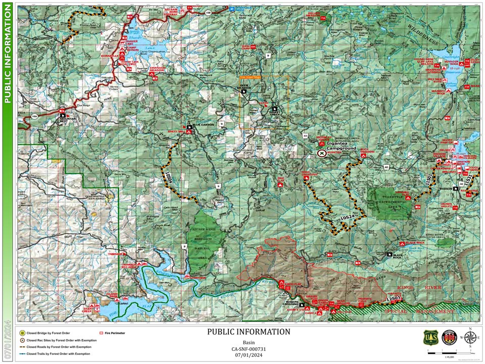
Previous Information:
Sierra National Forest Basin Fire Update for Sunday, June 30, 2024: 0% Containment at 9,549 Acres – Includes Public Information Map
