


Thursday, July 4, 2024 Update:
Sierra National Forest Basin Fire Update for Thursday, July 4, 2024: 46% Containment at 13,979 Acres – Includes Public Information Map
Facebook Live Event TODAY - Fire Updates: Speakers from California Interagency Incident Management Team 11, the US Forest Service and Fresno County Sheriff's Office will provide an update on the Basin Fire. (20+) Basin Fire Update | Facebook
July 3, 2024 - The Basin Fire northeast of Fresno is currently at 13,926 acres and 26% containment. The fire is burning primarily in dry, dense grass within the Rough Fire scar from 2015.
PEOPLE AND EQUIPMENT: 1,118 personnel, 22 crews, 65 engines & 9 helicopters.
| Current as of | Wed, 07/03/2024 - 11:09 |
|---|---|
| Incident Time Zone | America/Los_Angeles |
| Incident Type | Wildfire |
| Cause | Under Investigation. |
| Date of Origin | Wed, 06/26/2024 - 22:29 |
| Location | East of Pine Flat Reservoir, 46 miles East of Sanger |
| Incident Commander | California Incident Management Team 11 assumed command of the Basin Fire at 7:00 on June 28th. |
| Incident Description | The Basin Wildfire is burning in grass, chapparal and oak timber. It is also burning in steep terrain. |
| Coordinates | 36° 51' 52'' Latitude -119° 6' 9
'' Longitude |
| Total Personnel: | 1118 |
|---|---|
| Size | 13,926 Acres |
| Percent of Perimeter Contained | 26% |
| Fuels Involved |
Tall Grass, Brush, and Hardwood (Oak) Litter. The fire perimeter falls with in the regional Fuels and Fire Advisory for California Grass and Herbaceous-Dominated Ecosystems. Heavy grass fuel loading is predominate in the surrounding area with a FDFM at 3%. Live fuel moisture is near average with 1,000 hour fuels at average. ERC's are average for this time of year as well |
| Significant Events |
Active with Uphill Runs and Short-range Spotting. Continued growth to the western and northwest portion of the fire. Moderate to large areas of intense |
| Planned Actions |
This fire is a full suppression fire. The current strategy of using tactical ridges and indirect line reduces |
|---|---|
| Projected Incident Activity |
12 hours: Diurnal winds will push the fire to the west along the Kings River. These winds will also influence fire movement in Dinky Creek north Balch Camp. |
| Weather Concerns |
A dangerous, long duration heat wave has started today. Temperatures around the fire are running 3-5 degrees warmer than yesterday with RH 2-4% lower than yesterday. High pressure will build over the region and bring 7-10 days of high heat and lowering RH and lead to extended period of elevated fire danger and excessive heat exposure. Triple digit temperatures are expected across the lower eleva1ons of the fire later in the week and extending thru the holiday weekend. |
|---|
CURRENT SITUATION: The Basin Fire northeast of Fresno is currently at 13,926 acres and 26% containment. The fire is burning primarily in dry, dense grass within the Rough Fire scar from 2015.
One week after it started, the Basin Fire northeast of Fresno is at 13,926 acres. Firefighters have worked hard to safely earn 26% fire containment along the Kings River corridor, a positive trend. The fire is burning primarily in dry, dense grass within the Rough Fire scar from 2015.
Fire growth slowed under higher humidity for the second day in a row Monday, with some fire movement north toward Dinkey Creek, and also to the west/northwest. Priority firefighting efforts continued to effectively protect structures and energy infrastructure at Balch Camp. The southwest front of the fire burned up to the contingency bulldozer line on Sacate Ridge. Today, crews will keep improving this contingency line. The objective is to tie this line in with existing roads and to complete fuel breaks around the west and north of the fire. Three spike camps have been set up closer to the fire perimeter, allowing crews to overnight near the fire, reducing travel time so crews can work more on the fire line.
A heat wave will continue today, bringing hotter temperatures and lower relative humidities throughout the week. The National Weather Service has issued an EXCESSIVE HEAT warning from July 2nd to July 8th: this is a long duration, high impact and dangerous heat wave.
The Basin Fire started on June 26th and the cause is currently under investigation. Currently, the fire is burning at 2000-4500 elevation, northeast of Pine Flat Lake, west of the Spanish Mountain, south of Black Rock Rd (11S012) and north of the South Fork of the Kings River.
EVACUATIONS: There are mandatory evacuation orders for Fresno County zones K29, K30, K31, K40, K41, K166. Evacuation warnings are in effect for zones K61, and K76. Please check the Fresno County Evacuation map: https://www.arcgis.com/apps/webappviewer/index.html?id=e7d6006a016a444db8b210ac4d2eb5cf
The Sierra National Forest has implemented new temporary fire restrictions prohibiting campfires, welding, and smoking in non-developed campsites. Visit https://www.fs.usda.gov/alerts/sierra/alerts-notices for full details of the fire restrictions and Forest Order.
NEW Temporary Partial Forest Closure Order for the Basin Fire: To ensure the safety of the public and our firefighters, The Sierra National Forest has issued a Temporary Forest Closure for the Basin Fire area. Effective June 30, 2024, the closure will remain in effect until July 30, 2024. We urge the public to respect all closure signs and barriers and to avoid the area to prevent any potential accidents or interference with firefighting efforts. Please visit https://www.fs.usda.gov/sierra for the forest order and area map.
Forest Visitors: This may impact your Fourth of July holiday plans! The following campgrounds are CLOSED due to this fire: Bear Wallow Campground, Black Rock Campground, Gravel Flat Group Campground, Kirch Flat Campground, Kirch Flat Group Campground, Oak Flat Campground, Ross Crossing Campground, Sawmill Flat Campground. Please support our firefighters and stay out of this area.
Closures: Road closure signs have been placed on the perimeter of the fire. The public should review which roads are closed before traveling into the area because no one will be allowed to enter zones under evacuation warnings. To access websites showing both evacuation orders, road closures and many other emergency resources, visit: http://www.fresnocountyemergency.com
Smoke - Visit AirNow to find out the Air Quality Index in your area. As smoke gets worse, the amount of particles in the air changes - and so do the steps you should take to protect yourself. AirNow recommends precautions you can take to protect your health when air pollution gets bad
Click here for full size map
Public Information Map for Wednesday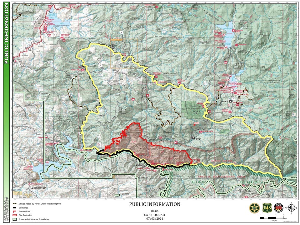
Previous Information:
