


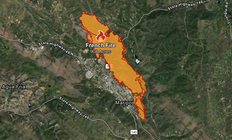
CAL FIRE Perimeter map of the French Fire on Friday evening.
Sunday, July 7, 2024 Updates:
Mariposa County French Fire Updates for Sunday, July 7, 2024
July 6, 2024 – The Mariposa County French Fire was first reported at around 6:04 P.M. on the CHP website on Thursday, July 4, 2024. The French Fire reported by CAL FIRE is at 908 acres, with 25% containment.
7:20 P.M. Update Per CAL FIRE: French Fire in Mariposa County is 908 acres, with 35% containment.
Resources Assigned: 1,179
Personnel: 4
Helicopters: 107
Engines: 17
Dozers: 20
Water Tenders: 32
Crews: 90
Other Assigned
Numerous firefighting air tankers from throughout the State are flying fire suppression missions as conditions allow.
Status Update
Situation Summary
Minimal fire activity and growth was observed throughout the day as the fire remains within containment lines. Crews continue to reinforce containment lines around the fire, mop up and patrol.
Damage Assessment is ongoing.
Evacuation Information
Evacuation Orders and Warnings
Evacuation Orders
- Stockton Creek Reservoir
- TrailRoad to MCHS
Evacuation Warnings
- Old Hwy North from 140 to 10th street
- Hospital Road past John C Fremont hospital
- Grosjean Road
- Alta Vista Road
- Avoca Vale
- Stockton Creek Area
- Slaughterhouse from Hwy 140 to Allred
- Allred Road from Slaughterhouse to Hwy 49 South
Damages and Destruction
Confirmed: Damage to Property, Injuries, and Fatalities - 0
Structures: Damaged Residential, Commercial and Other - 4
Fatality: Confirmed Fire Personnel and Civilian Fatalities - 0
Injuries: Confirmed Fire Personnel and Civilian Injuries - 4
3:33 P.M. Update: Mariposa County Sheriff’s Office Releases Helicopter Footage of the French Fire Burn Scar
11:11 A.M. Update per CAL FIRE MMU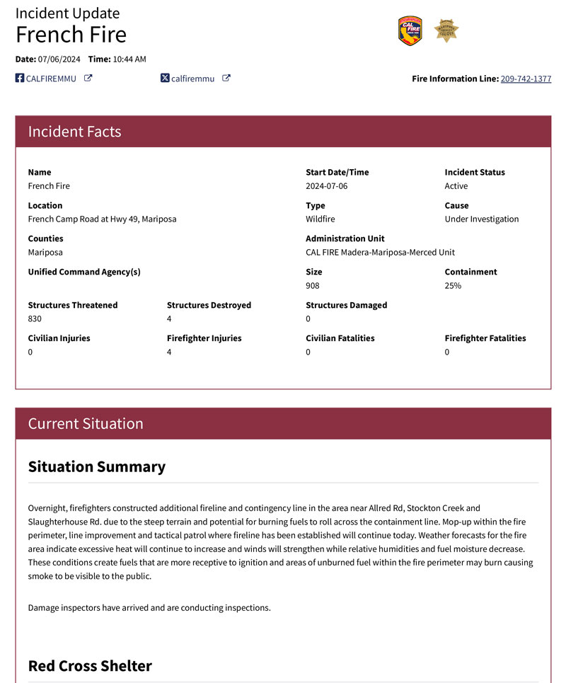
10:35 A.M. Update: FRENCH FIRE - MANDATORY EVACUATION ORDERS REDUCED TO EVACUATION WARNING RESIDENTS ONLY
French Fire: Update: 10am 7/6/2024
Fire Information Line: 209-742-1377
MAP OF THE AREA: MAP: https://arcg.is/TnzL0
CAL FIRE INCIDENT INFORMATION: https://www.fire.ca.gov/incidents/2024/7/4/french-fire/
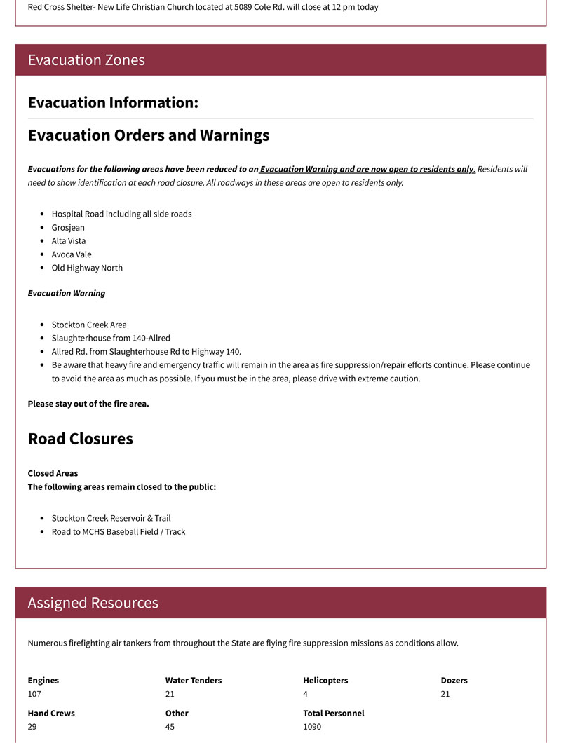
EVACUATION AREAS REDUCED:
Evacuations for the following areas have been reduced to an Evacuation Warning and are now open to residents only. Residents will need to show identification at each road closure.
- Hospital Road including all side roads
- Grosjean
- Alta Vista
- Avoca Vale
- Old Highway North
Be aware that heavy fire and emergency traffic will remain in the area as fire suppression/repair efforts continue. Please continue to avoid the area as much as possible. If you must be in the area, please drive with extreme caution.
ROADWAY INFORMATION:
All roadways in those areas will be open to residents only.
GENERAL INFORMATION FOR RETURNING HOME AFTER A FIRE
- Safety Information: Residents are asked not to wander around their property if possible. Please stay inside or near your homes while fire personnel remain working in the area. Fire personnel will continue to work in the above areas all hours of the day and night.
- Inspect surroundings with caution: Be extremely cautious around trees, power poles, and other structures that may have been weakened by the fire. High winds can easily topple such compromised structures.
- Maintain a fire watch: Regularly check your property for any signs of residual fires, like smoke or hidden embers, especially in concealed areas like roof gutters. Please call 911 if you need to report any fire danger or dangerous situations to your home or property.
Returning Home after a fire: Returning Home Checklist | CAL FIRE (readyforwildfire.org)
CLOSED AREAS:
The following areas remain closed to the public:
- Stockton Creek Reservoir & Trail
- Road to MCHS Baseball Field / Track
Overnight, firefighters constructed additional fireline and contingency line in the area near Allred Rd, Stockton Creek and Slaughterhouse Rd. due to the steep terrain and potential for burning fuels to roll across the containment line.
Mop-up within the fire perimeter, line improvement and tactical patrol where fireline has been established will continue today.
Weather forecasts for the fire area indicate excessive heat will continue to increase and winds will strengthen while relative humidities and fuel moisture decrease.
These conditions create fuels that are more receptive to ignition and areas of unburned fuel within the fire perimeter may burn causing smoke to be visible to the public.
Damage inspectors have arrived and are conducting inspections.
Incident Facts as of 7:30 A.M.
Current Situation
Situation Summary
Firefighters continue to gain containment and cool hot spots throughout the fire. Utility crews are working diligently to repair and replace damaged infrastructure. Many areas previously under an evacuation order have been repopulated, for detailed information review the section below.
Damage inspectors have arrived and are conducting inspections.
To see photos or videos from the incident visit us on Flickr at: https://www.flickr.com/photos/calfire/albums/72177720318519449/External Link
INCIDENT PHOTOS:
Red Cross Shelter
Evacuation Zones
Evacuation Information:
Evacuation Orders and Warnings
- Grosjean Rd
- Alta Vista Rd
- Avoca Vale
- Old Hwy North from 140 to 10th street
- Slaughterhouse Rd
- Hospital Road past John C. Fremont
- Road to MCHS Baseball Field / Track
- Stockton Creek Area
- Slaughterhouse from Hwy 140 to Allred
- Allred Road from Slaughterhouse to Hwy 49 South
Road Closures
Alta Vista
Avoca Vale
Hospital Road past John C. Fremont
Old Hwy North from Hwy 140 to 10th Street
Repopulation
Evacuations for the following areas have been reduced to FULLY OPEN.
- Jones Rd including all side roads- Excluding the Roadway to the MCHS Baseball Fields/Track
- Campbell Way
- Dexter View
- Pine Street
- Smith Rd from Hwy 140 to Hospital Rd
- Hospital Rd from Smith to just past John C. Fremont, Including St. Andrews Rd.
- Williams Road
Shelter In Place Lifted
- John C. Fremont Hospital
- Yosemite Inn
- Quality Inn
ROAD OPEN- Updated
Highway 140 is open through to Yosemite National Park without restriction.
Be aware that heavy fire and emergency traffic will remain in the area as fire suppression efforts continue. Please continue to avoid the area as much as possible. If you must be in the area, please drive with extreme caution.
Assigned Resources
Numerous firefighting air tankers from throughout the State are flying fire suppression missions as conditions allow.
Cooperating Agencies
| NAME | PHONE | ADDRESS | URL |
|---|---|---|---|
| Mariposa County Sheriff's Office, Mariposa County Fire Department, CAL OES, California Highway Patrol, CALTRANS, Mariposa County Public Works, PG&E, Red Cross, Central CA. Animal Disaster Team. |
Information Per Mariposa County Sheriff's Office.
French Fire: Last update from July 5, 2024
French Fire - Evacuation Orders Reduced to Fully Open
French Fire Information Line: 209-742-1377
View the most current evacuation map at: https://arcg.is/1XyXvD.
Evacuations for the following areas have been reduced to FULLY OPEN.
- Jones Road including all side roads - Excluding the Roadway to the MCHS Baseball Fields/Track
- Campbell Way
- Dexter View
- Pine Street
- Smith Road from Hwy 140 to Hospital Road
- Hospital Road from Smith Road to just past John C. Fremont, Including St. Andrews Road
- Williams Road
Shelter In Place Lifted
- John C. Fremont Hospital
- Yosemite Inn
- Quality Inn
Be aware that heavy fire and emergency traffic will remain in the area as fire suppression efforts continue. Please continue to avoid the area as much as possible. If you must be in the area, please drive with extreme caution.
ROAD OPEN - Updated
Highway 140 is open through to Yosemite National Park with no restrictions.
Be aware that fire and emergency traffic may remain in the area as fire suppression & repair efforts continue. Please drive slowly.
Related: Mariposa County French Fire Updates for Friday, July 5, 2024
French Fire has Started in Mariposa County Near Grosjean and Alta Vista Road - Updates
Mariposa County French Fire Photo Updates for Thursday, July 4, 2024
