


California and National Drought Summary for March 15, 2016
Summary
A westerly flow of Pacific weather systems pummeled the west coast this U.S. Drought Monitor (USDM) week, bringing much-needed rain and snow to northern California and the Pacific Northwest and improving the drought situation. An upper-level low cut off over Mexico early in the period, funneling tropical moisture into the Lower Mississippi Valley and causing widespread heavy rains and flooding. Meanwhile, upper-level ridging brought above-normal temperatures to much of the country. Precipitation largely missed the Southwest, central to northern Plains, and Southeast. Windy conditions coupled with temperatures well above normal were drying out soils across the Plains. Light to moderate showers fell across Puerto Rico, while Alaska and Hawaii saw another warmer- and drier-than-normal week.Northeast
It was another week of generally light precipitation (less than an inch) across much of New England and the mid-Atlantic, with amounts ranging from 1-2 inches in spots near the Great Lakes to less than 0.20 inch along the coast. A few areas of D0 lingered in New England and along the Maryland-West Virginia border where streamflow was low, soil moisture models indicated dryness, and streamflow was low. The week was too dry for improvement and too wet for D0 expansion, so no changes were made to the depiction in the Northeast.Southeast
There were a few reports of 0.5-1.0 inch of rain for the week in the D0 area of northeast Florida, but this was not enough to show improvement. Most stations from Florida to Virginia reported half an inch or less of rain. The western parts of the region (to central Kentucky, central Tennessee, and Alabama) received up to 3 inches of rain, with the Mobile, Alabama area reporting over 4 inches. Rainfall amounts steeply increased from there toward the Mississippi Valley. D0 expanded along the Georgia coast to Savannah, and a spot of D0 was introduced to Georgia and South Carolina in the vicinity of Augusta where soils are drying out. It's been dry and warm for the last several weeks in the Southeast. Precipitation deficits for the last 30 to 60 days are mounting from the Augusta area into Upstate and central South Carolina and the North Carolina Piedmont, and streamflow levels are dropping. This area could see expansion of D0 in the weeks ahead if significant rain doesn’t fall.Lower Mississippi Valley (Delta)
With a low cut off over Mexico, the upper-level circulation and synoptic pattern was set up perfectly for heavy rain, flooding, and severe weather along the Lower Mississippi Valley. Over 20 inches of rain fell during the week in parts of northeast Louisiana, with 10 inches or more spreading westward into eastern Texas and reaching as far north as western Tennessee. Two inches or more stretched as far west as the Rio Grande Valley, as far north as the Ohio Valley, and as far east as western Alabama. The D0 that was expanded in the Delta last week was mostly washed away this week. A small remnant spot of D0 remained over southwest Louisiana where less than 2 inches of rain fell this week and 14-day to 6-month precipitation deficits were still evident.Southern and Central Plains
The upper-level low pressure system funneled saturating rains into the eastern sections of the Southern Plains, but the rains mostly missed the western sections. As noted earlier, extreme eastern Texas received over 10 inches of rain this week, with 2+ inches stretching from southeastern Oklahoma to the lower and mid Rio Grande Valley. D0 and D1 in eastern, central, and southern Texas were eliminated. But rainfall amounts dropped off the further west you went in the region, with virtually no rain measured in the Texas and Oklahoma panhandles into southeast Colorado and southwest Kansas and across most of Nebraska. D0 expanded from the Texas and Oklahoma panhandles into these parts of Colorado and Kansas and also adjacent parts of New Mexico, and D1 was added to the Oklahoma panhandle. USDA NASS reports from March 13 had 45% of the topsoil and 37% of the subsoil in Kansas short or very short of moisture, statewide, with conditions worse in the southwest to central sections, and USGS streamflow was quite low in central Kansas. This was early in the growing season, so only 7% of the winter wheat crop was rated in poor to very poor condition. Even though an inch or more of rain fell locally in western Oklahoma, the D0-D1 was left unchanged there to reflect continued low lake levels. In southeast Colorado, hot temperatures & strong winds were drying out soils and sending crops downhill fast, and numerous range fires were also occurring.Northern Plains
Where it rained, less than half an inch fell but most locations had little to no rain this week. With dryness for the last 7 days to 6 months, and temperatures 16-20 degrees above normal the past 7 days accompanied by strong winds, soils are drying quickly. Local reports from McIntosh County in North Dakota indicate ponds and dugouts were very low and many small wetlands completely dry, and winter grain planted last fall was developing slowly. D1 expanded in North Dakota to extend from McIntosh/Dickey counties in the south to Eddy County in the north, and D0 expanded further into northeast North Dakota. D0 expanded in northwest and southwest South Dakota, with some expansion into adjacent Wyoming, to reflect dryness at the 7-day to 6-month time scales.The Far West
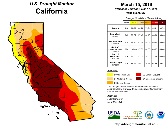
A steady stream of Pacific fronts brought precipitation to parts of the Far West every day this USDM week. The precipitation fell as rain at the lower elevations, with 1 to 2 feet of new snow measured at the higher-elevation SNOTEL sites in the Cascades and parts of the Sierra Nevada. Mountain snowpack was near to above average at most of the high elevation SNOTEL sites across the Far West. Ten inches or more of precipitation occurred in favored upslope areas of northern California to Washington, with 2 inches or more from central California to Washington. Precipitation amounts dropped off to the lee of the mountains and in Southern California, with essentially no precipitation falling along the California-Arizona border. This week’s precipitation, coupled with last week’s, totaled over 20 inches in the favored upslope locations. While it improved mountain snowpack and reservoir levels, significant precipitation deficits remained across California from the state’s 4 to 5 year drought.D1-D4 were pulled back in northern to central California and along the coast based on several criteria. Improvements were made where 6-month precipitation deficits were erased and reservoir levels were restored to average for this date. As of March 14, near-average reservoirs included Shasta Reservoir (106% of average), Folsom Lake (120%), and Lake Oroville (101%). Napa County reservoirs are all full, apart from Berryessa. But most of the other California Department of Water Resources (DWR) reservoirs were still below-average, including Trinity Lake in the north (at 60% of average). The surface soils were saturated due to the recent rains, but the deeper groundwater levels had not recovered. Wells were still going dry in Tuolumne County and deficits continued in groundwater and reservoir levels supplying areas such as San Joaquin County. DWR March 14 statistics showed mountain snowpack snow water content (SWE) at 100% of the April 1 average in the Northern region, 90% in the Central region, and 77% in the Southern region. With a near to below-normal mountain snowpack, streamflow is expected to be near to below normal during this summer at current projections.
D4 was removed from western Nevada east of Lake Tahoe in Washoe, Storey, Carson City, Lyon, and Douglas Counties. Even though this area was in a rain shadow and didn't benefit much from the systems of the last 2 weeks as did California, the area shows up as wet at 6-24 months, is benefiting from the above-normal SWE in the Sierra Nevada to the west, and has improved water supply along the Truckee and Carson rivers. D3 should be adequate to reflect the ongoing drought status.
In the Pacific Northwest, D0 was pulled back in eastern Washington-northern Idaho-northwest Montana to reflect above-normal precipitation for the water year-to-date (WYTD) and near to above-average reservoirs and SNOTEL SWE. The D1 in southeast Idaho was removed due to above-normal precipitation for the last 7 days to 12 months, and near to above-average reservoirs. In southwest Oregon, soils were saturated and producing sustained flow of water in draws where there is rarely water, higher elevation snowpack was above normal, and reservoirs have responded well. Crater Lake reported 120 inches of snow on the ground March 13, which compares to an annual peak daily value of 149 inches. D2 was pulled back in southwest Oregon to reflect these improved conditions. In eastern Oregon, the large Owyhee, Warm Springs, and Phillips Reservoirs were still below average, but the smaller reservoirs were near to above average (Bully Creek, Thief Valley, Beulah, Unity). In northeast Oregon, McKay Rerservoir was near normal but Cold Springs was still below normal. In central Oregon (Deschutes Basin), Wickiup was still below average but Prineville, Crescent Lake, Crane Prairie, and Ochoco were above average. SNOTEL SWE percentiles were a mixed bag in central to eastern Oregon (some above average and some below), but SNOTEL WYTD precipitation was mostly above average. D2 shrank in northeast Oregon to reflect improved reservoir and SWE conditions, but D1-D2 in southeast Oregon were left alone to reflect precipitation deficits which show up at many time scales.
Rockies, Intermountain West, and Southwest
Two inches or more of precipitation fell in the northern Rockies, improving SWE to near to above normal. Details are discussed in the Pacific Northwest section of The Far West section. Precipitation amounts dropped off considerably to the south, with little to no precipitation falling across much of the Southwest. Mountain snowpack was effectively melted out already in Arizona and New Mexico, having dry implications for spring and summer streamflow. SWE was near to above normal at many SNOTEL sites in Utah and Colorado and further north. WYTD precipitation was below normal across western New Mexico and much of Arizona. New Mexico was seriously drying out now with back-to-back days of red flag fire warnings and wind advisories. Some of the wildfires were large in southwest New Mexico. D0 and D1 expanded in western New Mexico, with a bit of D1 enlargement in adjacent eastern Arizona.Alaska, Hawaii, and Puerto Rico
The week saw continued dryness due to El Niño across Hawaii with spotty rainfall. Windy and cool/dry conditions worsened the drought situation overall with impacts coming in just about every week. D2 was introduced and D1 expanded in Kauai County, and the northwest corner of Kauai improved to D-nothing due to localized wet conditions in February. The FSA reported that non-irrigated pastures were failing, especially along the south side of the island. D1 expanded further east on Oahu, based on low rainfall and VHI data. Lanai was worsened by one category across the whole island. D2 expanded across the Big Island where vegetation continued to dry out and a rancher reported that 28 cows have died as a result of the drought. Freshwater aquaculture losses have also occurred near Hilo due to low stream levels.In Alaska, it was another drier- and warmer-than-normal week. An inch or more of precipitation was recorded in the southern coastal stations, but little to no precipitation fell inland. Streamflow was up, even though precipitation is below-normal, due to melting of mountain snow pack. The northern D0 expanded to the south (into Kuparuk and Kotukuk basins) and the southeastern D0 expanded to the northwest (into Upper Tanana basin) where SNOTEL SWE and WYTD precipitation were below normal.
Rainfall varied across Puerto Rico this week, with amounts ranging from a few tenths of an inch in the northwest and coastal southwest to over 2 inches in the western interior and northeast. Current to 28-day streamflow levels were represented by the current depiction, and enough rain has fallen this week and in the last month to prevent deterioration but not enough to justify further improvement, so no change was made to the depiction.
Looking Ahead
During the next 5 days (March 17-21), a ridge will develop over the western U.S., bringing warmer-than-normal temperatures, and a trough over the east with colder-than-normal air masses. Up to 2 inches of precipitation may fall along the northern California to Washington coast, with a tenth of an inch to an inch further inland over the interior Northwest and central to northern Rockies. But most of the West to Great Plains will see little to no precipitation. Coastal lows will spread up to an inch to 2 inches from central Texas, along the Gulf of Mexico Coast, and up the Atlantic coast, and an inch to 2 inches may fall over the western Great Lakes. But precipitation is expected to be less towards the Ohio Valley with less than a quarter inch falling from the Ohio and Tennessee Valleys to the Mississippi Valley.For days 6-10 (March 22-26), the odds favor below-normal precipitation in northern Alaska, in the Southwest to southern Plains of the CONUS, and along the Southeast coast, and above-normal precipitation across the northern tier states and along the Mississippi to Ohio Valleys. Above-normal temperatures are expected everywhere except northern Alaska, the Pacific Northwest, and southern Florida.
Author(s):
Richard Heim, NOAA/NCEI
Dryness Categories
D0 ... Abnormally Dry ... used for areas showing dryness but not yet in drought, or for areas recovering from drought.Drought Intensity Categories
D1 ... Moderate DroughtD2 ... Severe Drought
D3 ... Extreme Drought
D4 ... Exceptional Drought
Drought or Dryness Types
S ... Short-Term, typically <6 months (e.g. agricultural, grasslands)L ... Long-Term, typically >6 months (e.g. hydrology, ecology)
Source: National Drought Mitigation Center
