


Meadow Fire in Yosemite National Park Information for Thursday, September 11, 2014
Update: 7:40 P.M.
4,906 acres, 50% contained.
Type 2 Central Sierra IMT 2 (Cooper) in command.
The most southern portion of the fire still holds significant heat, with isolated heat sources scattered through the fire.
These heat sources continue to appear with todays continued high temperatures and decreased relative humidity.
Commitment of Forest Service air and ground resources.
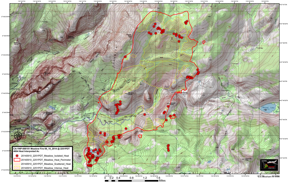
Update: 12:00 P.M. - Meadow Fire Heat Perimeter Map
Click here for a Large Map
Thursday Morning Update
Acres Burned: 4,906
Containment: 23%
Fire Start Date: July 19, 2014
Fire Discovered: August 15, 2014
Fire Cause: Lightning
Estimated Containment: September 21, 2014
Structures Threatened: 0
Structures Damaged: 0
Injuries: 0
Total Personnel: 556
Cost To Date: $1.8 million
Summary
The Fire is located within the designated wilderness of the Yosemite National Park in Mariposa County and is currently within Little Yosemite Valley between Half Dome and Mount Starr King on both sides of the Merced River.
The fire spread significantly due to a wind event which occurred on September 7, 2014.
Approximately 100 hikers and backpackers were evacuated from the fire area and an additional 85 hikers and climbers were evacuated by helicopter from the Summit of Half Dome on September 7 due to the rapid spread of the fire. Helicopters from the California Highway Patrol, U.S. Forest Service, Sequoia/Kings Canyon National Park and Cal Fire were utilized to affect the evacuations.
Recreation and businesses remain open in the Yosemite National Park except trail areas listed below.
Fire Update
Firefighter and public safety remains the highest priority. Fire crews are being sensitive to environmental and cultural resources in and around the fire area.
Last night’s infrared flight showed intense heat and hot areas around the north and southeast areas of the fire. Overall, infrared indicates there are still pockets of intense heat scattered through the fire. Due todays increased temperatures and low relative humidity, spots outside the current fires perimeter are expected to flare.
Due to the extremely steep, rugged and inaccessible terrain, some fire crews are being flown into the area by helicopter. Air resources, including nine helicopters are being utilized along the fire-line to slow the forward progress of the fire and to cool down hot spots. Due to the potential fire growth and extensive amount of work which remains, a high commitment of resources will be required.
Fire crews are using Minimum Impact Suppression Tactics (M.I.S.T). Fire crews are confining and containing the naturally caused fire by utilizing natural barriers such as, rock to rock, rock to domes, decomposed granite (DG) to sparse fuels. Crews are working hard to maintain natural habitat in the wilderness.
The fire continues to burn through popular hiking areas in Yosemite National Park and trail closures still remain in effect.
Smoke from the Meadows Fire will continue to impact visitors, campers and employees overnight and in the early morning hours in Yosemite Valley.
Fires of this magnitude can produce heavy smoke that blows down into Yosemite Valley. Be prepared for smoke in the unhealthy AQI range normally worse in the mornings with some clearing in the afternoon hours.
Information for schools can be found on this site and links to current air quality updates for this incident will be posted on the California Smoke Information blog.
Trail Closures:
By order of the Superintendent of Yosemite National Park and under authority of Title 36, Code of Federal Regulations, Section 1.5(a) and Section (a)(1):
-Echo Creek Drainage to Little Yosemite Valley
-Sunrise Creek Drainage to Little Yosemite Valley
-Merced River Corridor to Merced Lake Ranger Station
-Nevada Falls east through Little Yosemite Valley along the Merced River
-Sunrise Trail to Clouds Rest from Tenaya Lake
Cooperating agencies include
U.S. Forest Service, National Weather Service and California Conservation Corp.
For More Information:
-Fire information: gary_wuchner@nps.gov,
-Fire Information call center: (209) 372-0327; 372-0328; and, 372-0329.
-For Yosemite air quality data and webcams: www.nps.gov/yose/naturescience/aqmonitoring.htm
-For smoke updates: www.californiasmokeinfo.blogspot.com
Wednesday Evening Update
4,906 Acres with 23% Containment
The fire most likely started on July 19th 2014, near Starr King Lake after a lightning storm passed through the area. Due to the remoteness of the location and fire behavior, the fire was first reported August 15th 2014. The fire is in an area designated as wilderness in Yosemite National Park, within the Little Yosemite Valley, Mariposa County. The original fire was impacted by a wind event that caused the fire to spread significantly on September 7th 2014. The Meadow Fire will be fought using Minimum Impact Suppression Tactics (M.I.S.T) to help preserve the natural ecology of the Yosemite Wilderness. The Wilderness Act 1964, expects Federal Agencies to allow natural processes to maintain the natural ecosystem.
Basic Information
| Current as of | 9/10/2014 8:03:49 PM |
|---|---|
| Incident Type | Wildfire |
| Cause | Lightning |
| Date of Origin | Saturday July 19th, 2014 approx. 08:00 AM |
| Location | East of Half Dome in the Merced River Drainage at Little Yosemite Valley |
| Incident Commander | David Cooper SCSIIMT2 |
| Incident Description | Wildfire In The Wilderness |
Current Situation
| Total Personnel | 556 |
|---|---|
| Size | 4,906 Acres |
| Percent of Perimeter Contained | 23% |
| Fuels Involved | Timber(litter and understory), timber brush and ground litter. |
| Significant Events | Heavy helicopters have worked hot areas near the fire line in Divisions S,G and E, most of the day. Other areas of heat include the southeast portion of the fire in Div. A and W. Overall, there are still pockets of intense heat scattered through the fire. Today's increased temperatures and decreased relative humidities, spots outside the fires perimeter continue to show up. These spots will continue to the advancement of the fire. |
Outlook
| Planned Actions | Construct and improve direct fire line where possible. Div.G and K are the highest priorities due to unburned pockets of fuel and access issues. Hold and improve existing constructed perimeter, point protection. Spot fires have been surfacing which are being addressed by personnel and equipment. Fire activity within control lines is mainly in the downed dead fuels and roots. Continued direct and in-direct fire line construction. |
|---|---|
| Projected Incident Activity | Fire continues to move to the north and east. Fire continues to burn between granite domes. Many natural barriers are being utilized during line construction. The fire is not as active on the east flank, facing the Yosemite Valley floor. Perimeter is expected to grow to the west in Divisions S and K, interior fire activity within control lines is also expected to continue as daytime temperatures increase. Also, numerous heat sources were showing in the southeast, east and northwest portions of the fire. RE-burn potential remains, requiring a high commitment of resources. |
| Remarks | The fire is located in a very popular area within the Yosemite National Park Wilderness. A strategy is being implemented using MIST tactics. Crews are being spiked out in the wilderness at several locations to reduce helicopter flights into the wilderness. Helicopters are being used to support crews with water drops. The highest priority is to secure the west flank Divisions A and D which will allow for the opening of the trail to Half Dome. The second priority is protection for the three High Sierra Camps, operated by the park concessionaire, located at Vogelsang, Sunrise Meadow and Merced Lake. Bears continue to be a major issue with fire crew safety in spike camps and along the fire line. Extensive measures are being taken not to attract bears to the food and other supplies. Trash is being backhauled daily. |
Current Weather
| Weather Concerns | A ridge of high pressure will remain anchored along the west coast bringing dry weather, clear skies and above normal temperatures to the district through early next week. Low daytime humidities and moderate nighttime humidity will remain. Generally light terrain driven winds will prevail through the period. |
|---|
