


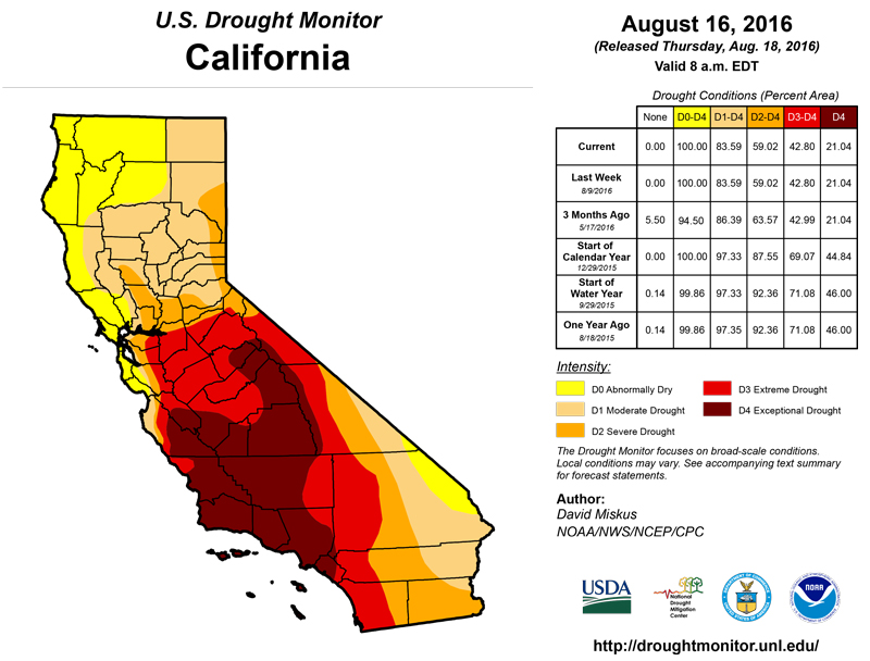
California and National Drought Summary for August 16, 2016
Summary
August 18, 2016 - A series of slow-moving or stationary cold fronts plus a westward wandering upper-air low along the Gulf Coast produced widespread moderate to heavy (more than 2 inches) rains in portions of the north-central Plains and upper Midwest, much of the Corn Belt, southern Great Plains, Ohio and lower Mississippi Valley, along the Gulf Coast, and the Northeast. Record flooding occurred in Louisiana where up to 2 feet of rain inundated the southern half of the state, requiring thousands of water rescues and drowning several people. Weekly amounts exceeding 8 inches also fell on southeastern Missouri, southern Illinois, north-central Indiana, and southwestern Lower Michigan. The southwest monsoon was also active, especially in New Mexico and southeastern Arizona where 1-2 inches of rain fell on several locations. Oppressive heat and humidity enveloped the northeastern quarter of the Nation, with weekly temperatures averaging more than 6 deg F above normal. Highs in the nineties were common, with some locations nearing triple-digits, but when combined with dew points in the seventies, apparent temperatures were unbearable to dangerous. In contrast, near to subnormal readings occurred across most of the western half of the U.S. and along the Gulf Coast. Most of Puerto Rico, Alaska, and Hawaii measured light to moderate rainfall, but not enough fell on the drought areas for any improvement.The Northeast and the eastern Great Lakes Region
Beneficial rains (2 to 4 inches, locally to 6 inches in northwestern Pennsylvania and 8-10 inches in northern Indiana and southwestern Lower Michigan) fell across much of the northeastern quarter of the Nation, preventing additional deterioration, and in several areas, improving conditions. In general, enough rain (more than 2 inches) fell for a one-category improvement in the southern half of Lower Michigan, most of Indiana, the western half of and northeastern Ohio, northern Pennsylvania, extreme southwestern and south-central New York, northwestern New Jersey, northeastern Connecticut, and southwestern New Hampshire. The rains were especially welcome as temperatures averaged well above normal (6 to 10 deg F) and felt even more oppressive with the high humidity. USGS stream flows showed short-term (instant, 1- and 7-day averages) recovery in these areas (above to much-above normal), although longer-term (14- and 28-day averages) values were in the normal to subnormal class. While the rains may have aided the soybean crop, the precipitation may have been too late to help earlier planted corn.However, some portions missed out on the heavy rains (e.g. western New York and coastal New England) where less than 0.5 inches fell). Accordingly, conditions deteriorated there, including an expansion of D3 into northeastern Massachusetts and southeastern New Hampshire, and two new D3 areas in western New York, one along the I-90 corridor, and another in the southern Finger Lakes region. 90-day deficits of 4-8 inches were common across coastal New England and western New York, with 8-12 inch accumulated deficiencies at 6-months. In eastern Massachusetts, USGS stream flows failed to rise substantially after this week’s rains, remaining in near- to record low levels at all time periods. The Massachusetts Drought Management Task Force met on Aug. 11 and recommended that all of the state be included in the drought declaration, and that the drought watch for central and northeast Massachusetts be upgraded to drought warning. In western New York, wells in Genesee County had gone dry or had reduced pressure, while officials in Ithaca, NY, stated on July 27 that if significant rains did not fall soon, the town and Cornell University could be out of water in the next 30 days as their municipal water sources at Falls and Six Mile Creeks were at record low levels. According to NASS/USDA, Aug. 14 statewide topsoil moisture rated short to very short was at 100, 92, 80, 67, 62, 59, and 55 percent in RI, MA, CT, NH, VT, OH, and ME, respectively, and those values represented a weekly improvement or no change. Statewide subsoil moisture rated short to very short was similar, with values ranging from 89% in Connecticut to 26% in New Jersey, with most other Northeastern states above 50%. Statewide pastures conditions (%) with over half rated very poor or poor included CT (87), RI (80), NH (78), MA (58), and ME (52). Farther west, short-term abnormal dryness (60-days) has expanded in southeastern Wisconsin as accumulated shortages have reached 3-5 inches.
The Southeast and lower Mississippi Valley
A slow-moving upper-air low tracked westward along the Gulf Coast and eventually stalled over Louisiana, drawing tropical Gulf moisture northward and producing copious amounts of rain, especially in the lower Mississippi Valley. With up to 2 feet of rain measured, historical flooding occurred along the Amite, Comite, Tickfaw, and Tangipahoa Rivers in southern Louisiana. Also during the period, a stalled cold front over the southern Plains tapped moisture from both the southwestern monsoon and the upper-air low, triggering showers and thunderstorms in most of Texas and the lower and middle Mississippi Valleys. Light to moderate showers (1-3 inches) also fell on central South Carolina, northeastern Georgia, and western North Carolina. With such widespread and heavy rainfall in southern and western areas, a general 1-category improvement was made. This included D0 improvement in northern Florida, D0 erasure in southwestern Alabama (near Mobile), a 1- and occasionally 2-category improvement in southern and central Mississippi (which included a reassessment of rains the past 30-days with both short and long-term blends trending near normal and USGS stream flows at near normal levels at all time periods), and more D0 removal in Louisiana and Arkansas except for a few small patches where the rains were less than an inch. In the western Carolinas and northeastern Georgia, rainfall was enough for a 1-category improvement in a few counties.Unfortunately, little or no rain was measured across the main Southeast drought area in northern Alabama, Georgia, southeastern Tennessee, and western South Carolina, and also southward into southeastern Alabama, central Georgia, and along coastal Georgia. The past 60-days have been quite dry across most of Georgia, southeastern Tennessee, and coastal sections of southern South Carolina southward into central Florida, producing deficits of 2-6 inches inland and 4-8 inches along the coast. Fortunately temperatures were near or slightly above normal, but evaporative demands are still high during mid-August. Accordingly, a conservative degradation was made in northern Alabama (D2), southeastern Tennessee (D3), and central (D1 and D3) and coastal (D0) Georgia. Surprisingly, the Aug. 14 USDA/NASS crop conditions for peanut and cotton in Georgia and Alabama were fairly good, although pasture and range conditions rated very poor or poor stood at 32 and 23 percent, respectively. Not surprisingly, the USGS streams with the lowest percentiles (much below normal flows) were located near the D3 areas in Alabama, Georgia, and Tennessee.
Southern Plains
Abundant moisture from the southwest monsoon and the upper-air low interacted with a stationary cold front over the southern Plains, triggering numerous scattered showers and thunderstorms across southern and eastern sections of Texas and extreme southeastern Oklahoma. The rains, however, mostly missed the Texas Panhandle and the remainder of Oklahoma. With the scattered nature of the storms, totals varied widely, resulting in a spotted look to the remaining drought areas, although most changes were 1-category improvements (using 2-3 month tools). In contrast, subnormal rainfall resulted in some small degradation in the Texas Panhandle, extreme southern Texas, and in southern and northeastern Oklahoma. Field reports out of central and eastern Wagoner County (northeast OK) indicated worsening agricultural impacts due to less rainfall than surrounding counties, resulting in a D1 expansion and new D2 area.North-Central Plains and western Corn Belt
With July and August normally the two driest months of the year, not too many changes are typically expected during the late summer in the Pacific Northwest. This was the case this week as little or no precipitation occurred, and temperatures averaged slightly above normal. Farther east, unsettled weather (cool and showery) was observed in the northern Rockies and northern Montana, which was enough to prevent any deterioration but not enough for improvement. Except for the impact lines redrawn for better clarity of the impact types, no other changes were made.California and western Great Basin
Since this is the normally dry and warm time of the year when no real changes are expected to occur, and since both temperature and precipitation was near normal this week, there were no changes made on the map.The Southwest (4-Corner States)
Since the onset of the southwest monsoon in late July, scattered showers continued this week, with the greatest totals (1-3 inches) occurring in southeastern Arizona, southern and northeastern New Mexico, and southwestern Texas. With this week’s totals adding onto accumulated surpluses out to 3-, 6-, and even 12-months, some small improvements were made in southeastern Arizona (D2 to D1), southwestern Texas and southern New Mexico (D1 to D0), and D0 to nothing in southwestern and northeastern New Mexico and southwestern Texas (near El Paso). Enough rain has fallen over other areas since mid-July to keep conditions status-quo. An exception was in south-central Colorado where D0 was added as seasonal precipitation expectations have been below normal. In northern Colorado, a small area of D1 was added as short-term dryness was putting a strain on unirrigated vegetation, with some tree leaves becoming crispy. The impact lines were redrawn to reflect recent short-term wetness (SL changed to L in southern Arizona), and a SL buffer in eastern New Mexico (between the L to the west and S to the east).Alaska, Hawaii, and Puerto Rico
In Alaska, moderate to heavy (2-6 inches) rains fell on southern and southeastern coastal sections while light to moderate totals (0.5-2 inches) was observed across the southern half of the state. Less than 0.5 inches was reported across northern portions of Alaska, keeping the D0 intact. In Hawaii, after a rather wet period due to rain from several tropical systems, a quieter pattern emerged this week, albeit still active. The showers, however, were not enough to warrant any improvements from last week (e.g. status-quo). In Puerto Rico, moderate to heavy (4-10 inches) showers were recorded in western and eastern sections of the island, with lower amounts near the D0-D1 area (south-central sections). Since deficits at 60- and 90-days still remained, the area was left as is.Looking Ahead
During the next 5 days (August 18-22), the Far West should stay seasonably dry. Meanwhile, the heaviest rains (1-4 inches) should fall on the southern Great Plains and upper Delta (TX-OK-AR), from southern Montana and northern Wyoming eastward to northern sections of Wisconsin and Michigan, on the southern Appalachians, and along the Carolinas coast. 5-day temperatures will be above-normal in the Far West and the Atlantic Coast States while subnormal readings are expected in the middle third of the Nation.During August 23-27, the odds favor above-median precipitation in the southern three-quarters of the Plains and most of Alaska, while sub-median rainfall is favored in Arizona, Pacific Northwest, and mid-Atlantic southward to the central Gulf Coast. Subnormal temperatures are likely in the southern two-thirds of the Rockies and Plains, the Tennessee and lower Ohio Valleys, and central Appalachians, while above-normal readings are favored in southern Alaska, the Pacific Northwest, and along the East Coast.
Author(s):
David Miskus, NOAA/NWS/NCEP/CPC
Dryness Categories
D0 ... Abnormally Dry ... used for areas showing dryness but not yet in drought, or for areas recovering from drought.Drought Intensity Categories
D1 ... Moderate DroughtD2 ... Severe Drought
D3 ... Extreme Drought
D4 ... Exceptional Drought
Drought or Dryness Types
S ... Short-Term, typically <6 months (e.g. agricultural, grasslands)L ... Long-Term, typically >6 months (e.g. hydrology, ecology)
Source: National Drought Mitigation Center
