


Click here for Monday Information
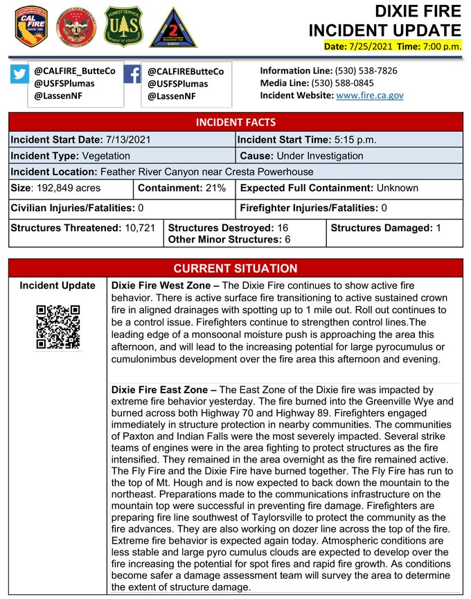
Evening Update: CAL FIRE reports the Dixie Fire in Butte and Plumas Counties is at 192,849 Acres with 21% Containment.
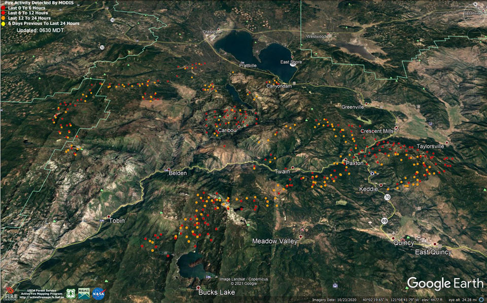
MODIS map of the Dixie Fire in Butte and Plumas Counties on Sunday at 5:30 A.M PST
Note: 960 Pixels Wide
MODIS Active Fire Mapping Program Frequently Asked Questions
Update 4:20 P.M. Lassen County Evacuation Warning (pdf 161 kb)
Update 3:00 P.M. Plumas County Sheriff;
Due to additional fire activity, a Mandatory Evacuation Order has been issued for:
Update 12:50 P.M. Plumas County Sheriff;
Due to additional fire activity, a Mandatory Evacuation Order has been issued for:
Genesee Valley: ALL OF GENESEE VALLEY, southeast of Taylorsville up the Genesee Rd to just south of Babcock Crossing, Walker Mine Road, north portion of Beckwouth Genesee Road.
North and Eastern parts of Indian Valley: From upper Williams Valley and upper Pecks Valley east to include all portions of North Valley Rd, Diamond Mtn Rd, and North Arm.
Grizzly Mountain: South of Genesee Valley to 24N16 Road and east to the 25N42 intersection with Beckwourth Genesee Rd.
Evacuate to the north. Take Hwy 89 to Hwy 147. The shelter is established at Lassen Community College 478-200 CA-139, Susanville, CA 96130
You should take your family, pets, and necessary items including medications and important papers and evacuate now.
Check in with your local shelter (even if you don’t intend to stay there). Check in with them and let them know where you will be in case your family is looking for you.
Drive with your lights on, safely and SLOWLY remaining aware of your surroundings as you leave.
Additional warnings will follow shortly.
Update 12:15 P.M.
Yesterday the Dixie Fire experienced significant growth and very challenging fire conditions. Extreme fire behavior is expected again today. Atmospheric conditions are less stable and therefore large pyrocumulus clouds are expected to develop over the fire increasing the potential for spot fires and rapid fire growth. The Dixie Fire remains in Unified Command, with two teams overseeing the fire: CAL FIRE Incident Management Team 1 on the West Zone and California Interagency Incident Command Team 2 on the East Zone.
The Dixie Fire is over 190,000 acres with 21% containment and the Fly Fire is 4,300 acres with 5% containment. There are over 5,000 fire personnel combined fighting the two fires.
The East Zone of the Dixie Fire was impacted by extreme fire behavior yesterday. The fire burned into the Greenville Wye and burned across both Highway 70 and Highway 89. Firefighters engaged immediately in structure protection in nearby communities. The communities of Paxton and Indian Falls were the most severely impacted. Several strike teams of engines were in the area fighting to protect structures as the fire intensified. They remained in the area overnight as the fire remained active.
The Fly Fire and the Dixie Fire have burned together. The Fly Fire has run to the top of Mt. Hough and is now expected to back down the mountain to the northeast. Preparations made around the communications infrastructure on the mountain top were successful in preventing fire damage. Firefighters are preparing fireline southwest of Taylorsville to protect the community as the fire advances. They are also working on dozer line across the top of the fire and burning operations may be necessary to protect the communities in this area. Firefighters will also be working at establishing fireline from Bucks Lake toward Twain. As conditions become safer a damage assessment team will survey the area to determine the extent of structure damage.
The West Zone of the Dixie Fire remained active overnight, with uphill runs, shortrange spotting and rollout. Critically low fuel moistures and recordsetting Energy Release Components (ERC) have caused difficulty in suppressing the fire spread. The fire continues to burn in a remote area with limited access, and extended travel times with steep terrain are hampering control efforts. A second incident base, in Westwood, has been established to support logistical needs of the fire.
Update 10:20 A.M. Plumas National Forest, Phases 1, 2, and 3 Expanded Dixie Fire Emergency Closure Order
Update: Smoke/Air Quality Outlook for the Dixie Fire in the Eastern Sierra for Sunday, July 25 and Monday, 26, 2021
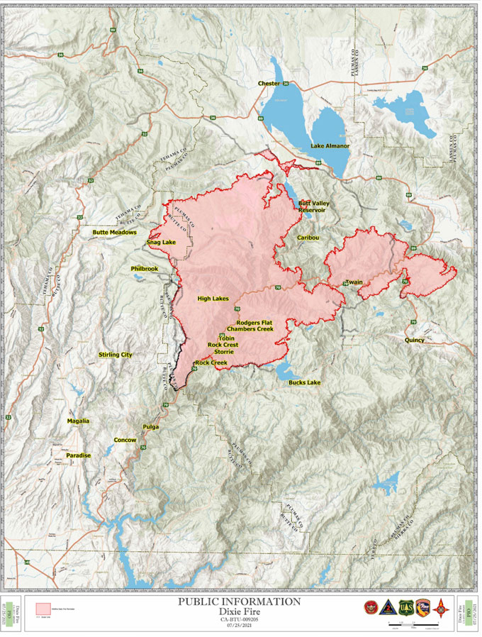
Update: Dixie Fire in Butte and Plumas Counties Briefing Map for Sunday, July 25, 2021 - Shows Divisions, Uncontrolled Fire Edge, Completed Dozer Lines
July 25, 2021 - Per CAL FIRE: Dixie Fire in Butte County and Plumas County is 190,625 acres and 21% contained for Sunday morning.
'Click' here to view full PDF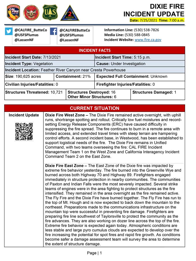
Click Here for Dixie Fire in Butte and Plumas Counties Saturday, July 24, 2021 Updates
